ENROUTE
.pdf4 MAR 11 |
ENROUTE |
EH-I |
TABLE OF CONTENTS
Limited or special coverages may not contain all items, but that material which is included should be arranged in the order outlined.
TABLE OF CONTENTS ............................................................................................................................... |
|
EH-I |
ENROUTE DATA |
|
|
Stockholm Radio - Long Distance Operational Control............................................................................... |
|
9 |
Oceanic Long-Range Navigation Information ........................................................................................... |
|
11 |
Designators of ATS Routes and its use in Voice Communications............................................................ |
|
15 |
Company Operational Control................................................................................................................. |
|
101 |
ENROUTE DATA - AFRICA |
|
|
Enroute Africa Chart Index...................................................................................................................... |
|
A-1 |
Secondary Surveillance Radar - SSR ................................................................................................... |
|
A-17 |
HF Communications Africa and Indian Ocean Region.......................................................................... |
|
A-21 |
IATA In-flight Broadcast Procedures - Africa/Indian Ocean ................................................................... |
|
A-31 |
Airway Restrictions - Africa (Lower and Upper Airspace).................................................................... |
|
A-101 |
ENROUTE DATA - ATLANTIC |
|
|
HF Communications North and South Atlantic Region ........................................................................ |
|
AT-21 |
VHF Air/Ground Communication Coverage at FL 300 ......................................................................... |
|
AT-22 |
North Atlantic European Routeing Scheme (NERS) Westbound Common Portion ............................. |
AT-47 |
|
North Atlantic European Routeing Scheme (NERS) General .............................................................. |
|
AT-49 |
North Atlantic European Route System (NERS) Eastbound Common Portion.................................... |
AT-55 |
|
North Atlantic European Route System (NERS) Eastbound Non-Common Portion + MIL .................. |
AT-91 |
|
North American Route Program (NRP).............................................................................................. |
|
AT-101 |
North American Routes (NARS) for North Atlantic Traffic .................................................................. |
|
AT-103 |
ENROUTE DATA - CHINA |
|
|
Preferential Route System - China..................................................................................................... |
|
CH-41 |
Flight Level Transition Procedures ................................................................................................... |
|
CH-201 |
ENROUTE DATA - EUROPE |
|
|
Enroute Europe Chart Index.................................................................................................................... |
|
E-1 |
Procedures for Finland ADIZ Flight ......................................................................................................... |
|
E-5 |
Alps Drift Down Orientation Chart ......................................................................................................... |
|
E-11 |
Secondary Surveillance Radar - SSR ................................................................................................... |
|
E-17 |
Danger Area Crossing Service and Activity Information Service - U.K. |
............................................... |
E-23 |
Altimeter Setting Regions...................................................................................................................... |
|
E-27 |
Domestic ATS Routes within Switzerland.............................................................................................. |
|
E-29 |
Coverage Lower Airspace Radar Service (LARS) - U.K. ...................................................................... |
|
E-33 |
Middle Airspace Radar Service - U.K. .................................................................................................. |
|
E-35 |
Airway Restrictions - Europe (Upper Airspace)................................................................................... |
|
E-101 |
Route Availability Document (RAD) - Europe...................................................................................... |
|
E-201 |
Route Availability Document (RAD) - Area Definitions ........................................................................ |
|
E-211 |
Route Availability Document (RAD) - City-Pair Level Capping ............................................................ |
|
E-221 |
Route Availability Document (RAD) - Routing Suggestions ................................................................ |
|
E-251 |
Route Availability Document (RAD) - DCT Direct Flight Plan filing limitations .................................... |
E-301 |
|
Route Availability Document (RAD) Route Restrictions |
|
|
Albania ............................................................................................................................... |
|
ALBANIA-401 |
Austria................................................................................................................................ |
|
AUSTRIA-401 |
Belgium ............................................................................................ |
BELGIUM and LUXEMBOURG-401 |
|
Bulgaria........................................................................................................................... |
|
BULGARIA-401 |
Croatia ............................................................................................................................... |
|
CROATIA-401 |
Cyprus................................................................................................................................ |
|
CYPRUS-401 |
Czech.................................................................................................................................... |
|
CZECH-401 |
Denmark ......................................................................................................................... |
|
DENMARK-401 |
Estonia ............................................................................................................................... |
|
ESTONIA-401 |
Finland ............................................................................................................................... |
|
FINLAND-401 |
France ................................................................................................................................. |
|
FRANCE-401 |
Germany .......................................................................................................................... |
|
GERMANY-401 |
Greece ............................................................................................................................... |
|
GREECE-401 |
Hungary ........................................................................................................................... |
|
HUNGARY-401 |
Ireland ................................................................................................................................ |
|
IRELAND-401 |
Italy ........................................................................................................................................... |
|
ITALY-401 |
Latvia .................................................................................................................................... |
|
LATVIA-401 |
© JEPPESEN, 1989, 2011. ALL RIGHTS RESERVED.

EH-II |
ENROUTE |
4 MAR 11 |
TABLE OF CONTENTS
Luxembourg ..................................................................................... |
BELGIUM and LUXEMBOURG-401 |
Macedonia, the former Yugoslav Republic of................................................ |
MACEDONIA, FYROM-401 |
Malta ...................................................................................................................................... |
MALTA-401 |
Netherlands............................................................................................................. |
NETHERLANDS-401 |
Norway ............................................................................................................................... |
NORWAY-401 |
Poland ................................................................................................................................. |
POLAND-401 |
Portugal.......................................................................................................................... |
PORTUGAL-401 |
Romania............................................................................................................................ |
ROMANIA-401 |
Serbia-Montenegro ................................................................................... |
SERBIA-MONTENEGRO-401 |
Slovakia............................................................................................................................ |
SLOVAKIA-401 |
Slovenia ........................................................................................................................... |
SLOVENIA-401 |
Spain....................................................................................................................................... |
SPAIN-401 |
Sweden .............................................................................................................................. |
SWEDEN-401 |
Switzerland .............................................................................................................. |
SWITZERLAND-401 |
Turkey.................................................................................................................................. |
TURKEY-401 |
United Kingdom ................................................................................................. |
UNITED KINGDOM-401 |
Flexible use of Airspace Conditional Routes - Europe ........................................................................ |
E-501 |
ENROUTE DATA - EASTERN EUROPE/EURASIA |
|
Enroute Europe Chart Index.................................................................................................................. |
EA-1 |
Enroute Eastern Europe Chart Index .................................................................................................... |
EA-3 |
Secondary Surveillance Radar - SSR ................................................................................................. |
EE-17 |
Airway Restrictions - Eastern Europe (Lower and Upper Airspace).................................................. |
EE-101 |
Flight Level Transition Procedures .................................................................................................... |
EE-201 |
ENROUTE DATA - MIDDLE EAST/SOUTH ASIA |
|
Enroute Chart Index ............................................................................................................................. |
ME-1 |
ADIZ Flight Procedures ........................................................................................................................ |
ME-5 |
Secondary Surveillance Radar - SSR ................................................................................................ |
ME-17 |
HF Communications Middle East and South East - Asia Region....................................................... |
ME-21 |
IATA In-flight Broadcast Procedures - Middle East/South Asia .......................................................... |
ME-31 |
Preferential Route System - Middle East/South Asia ......................................................................... |
ME-49 |
Airway Restrictions - Middle East (Lower and Upper Airspace) ....................................................... |
ME-101 |
© JEPPESEN, 1989, 2011. ALL RIGHTS RESERVED.
25 FEB 11 |
ENROUTE |
9 |
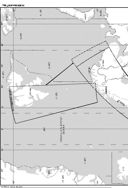
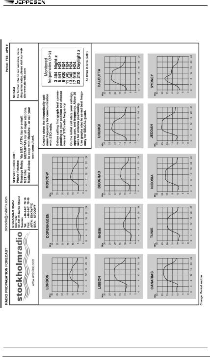
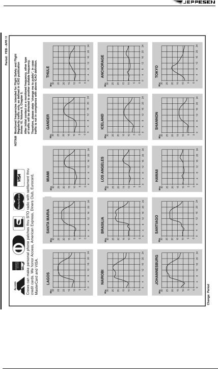
STOCKHOLM RADIO
LONG DISTANCE OPERATIONAL
CONTROL
 Period: FEB 11 - APR 11
Imaged by Jeppesen
10 |
ENROUTE |
25 FEB 11 |
|
STOCKHOLM RADIO |
|
 storadio@aviolinx.com
Imaged by Jeppesen

25 FEB 05 |
ENROUTE |
11 |
OCEANIC LONG-RANGE NAVIGATION INFORMATION
BASIC OCEANIC LONG-RANGE NAVIGATION AND COMMUNICATION REQUIREMENTS
Any operation which is conducted in international oceanic airspace on an IFR flight plan, a VFR controlled flight plan, or at night, and is continued beyond the published range of normal airways navigation facilities (NDB, VOR/DME), is considered to be a long-range navigation operation. Accurate navigational performance is required to support the separation minima which air traffic control units apply. These separation minima can be found in the International Civil Aviation Organization (ICAO) Regional Supplementary Procedures Document 7030 and the Oceanic Air Traffic Control Handbook (FAA Order 7110.83).
Federal Aviation Regulation (FAR) 91.703 requires that civil aircraft must comply with ICAO, Annex 2 when operating over the high seas. In addition, ICAO, Annex 6, Part II stipulates that an airplane operated in international airspace be provided with navigation equipment which will enable it to proceed in accordance with the flight plan and with the requirements of air traffic services.
Annex 2 further requires that an aircraft shall adhere to the “current flight plan unless a request for a change has been made and clearance obtained from the appropriate air traffic control facility.” Annex 2 also requires that “unless otherwise authorized or directed by the appropriate air traffic control unit, controlled flights shall, insofar as practicable: (a) when on an established ATS route, operate along the centerline of that route; or (b) when on another route, operate directly between the navigation facilities and/or points defining that route.” In the event that a controlled flight inadvertently deviates from its current flight plan, the following action shall be taken:
a.Deviation from track: if the aircraft is off track, action shall be taken forthwith to adjust the heading of the aircraft to regain track as soon as practicable.
b.Variation in true airspeed: if the average true airspeed at cruising level between reporting points varies or is expected to vary by plus or minus 5 percent of the true airspeed, from that given in the flight plan, the appropriate air traffic services unit shall be so informed.
c.Change in time estimate: if the time estimate for the next applicable report point, flight information region boundary or destination aerodrome, whichever comes first, is found to be in error in excess of three minutes from that notified to air traffic services, or such other period of time as is prescribed by the appropriate ATS authority or on the basis of air navigation regional agreements, a revised estimated time shall be notified as soon as possible to the appropriate air traffic services unit.
ICAO, Annex 6, Part II contains standards and recommended practices adopted as the minimum standards for all airplanes engaged in general aviation international air navigation. It requires that those airplanes operated in accordance with Instrument Flight Rules (IFRs), at night, or on a VFR controlled
flight have installed and approved radio communication equipment capable of conducting two-way communication at any time during the flight with such aeronautical stations and on such frequencies as may be prescribed by the appropriate authority.
All of the aforementioned requirements contained in Annex 2 are incorporated in Section 91.1 of the FARs for those aircraft operating under United States civil certification in international oceanic airspace.
USE OF VERY HIGH FREQUENCY (VHF) AND HIGH FREQUENCY (HF) FOR COMMUNICATION
Due to the inherent line of sight limitations of VHF radio equipment when used for communications in international oceanic airspace, those aircraft operating on an IFR or controlled VFR flight plan beyond the communications capability of VHF are required, as per ICAO, Annex 2, to maintain a continuous listening watch and communications capability on the assigned HF frequencies. Although these frequencies will be designated by Air Traffic Control, actual communication will be with general purpose communication facilities such as international flight service stations or Aeronautical Radio, Inc. (ARINC). These facilities are responsible for the relay of position reports and other pertinent information between the aircraft and Air Traffic Control.
SPECIAL NORTH ATLANTIC, CARIBBEAN AND PACIFIC AREA COMMUNICATIONS
VHF air-to-air frequencies enable aircraft engaged on flights over remote and oceanic areas out of range of VHF ground stations to exchange necessary operational information and to facilitate the resolution of operational problems. Air-to-air frequencies are charted on appropriate Jeppesen Enroute charts.
GUARD OF VHF EMERGENCY FREQUENCY
Pilots should remember that there is a need to continuously guard the VHF emergency frequency 121.5 MHz when on long over-water flights, except when communications on other VHF channels, equipment limitations, or cockpit duties prevent simultaneous guarding of two channels. Guarding of 121.5 MHz is particularly critical when operating in proximity to flight information region (FIR) boundaries.
© JEPPESEN SANDERSON, INC., 1987, 2005. ALL RIGHTS RESERVED.

12 |
ENROUTE |
25 FEB 05 |
OCEANIC LONG-RANGE NAVIGATION INFORMATION
USE OF NON-DIRECTIONAL BEACON (NDB) FOR NAVIGATION
The use of an NDB as the primary source of navigation for long-range oceanic flight presents the operator with numerous limitations and restrictions that are inherent in low frequency radio equipment and the low frequency signals they receive. These include:
NDB navigation aids of the highest power (2000 or more watts) which are maintained and flight-checked as suitable for air navigation, but are limited in their usable service and/or reception range to no more than 75 nautical miles from the facility, at any altitude.
Although the operator may be able to receive standard (AM/amplitude modulation) broadcast stations with NDB equipment, primary dependence on these facilities for air navigation is a questionable operating practice. The following are some of the inherent problems associated with reception of these stations:
a.Infrequent identification of the station.
b.Identification of foreign language stations may be impossible without some knowledge of the language.
c.Transmitter sites are not always collocated with studio facilities.
d.Termination of service without notice.
e.Weather systems causing erratic and unreliable reception of signal.
f.Atmospheric disturbances causing erratic and unreliable reception of signal.
g.No flight checks conducted to verify the suitability and reliability of the facility and its signal for use in air navigation.
h.Fluctuation (bending) of signal due to shoreline/mountain effect.
i.Standard broadcast stations are not dedicated for air navigation purposes.
Considering the aforementioned limitations, the operator should be able to navigate the aircraft so as to maintain the track/course and the tolerances specified in the Air Traffic Control Clearance (as per ICAO, Annex 2 and the Regional Supplementary Procedures Document 7030). Realizing that an error of 10 degrees, at a distance of 2000 miles, equates to approximately 350 miles of course deviation, the inadequacies of the non-directional beacon as the sole source of navigation for oceanic flight must be evaluated carefully.
SPECIAL EMERGENCY (AIR PIRACY)
a.A special emergency is a condition of air piracy, or other hostile act by a person(s) aboard an aircraft, which threatens the safety of the aircraft or its passengers.
b.The pilot of an aircraft reporting a special emergency condition should:
1.If circumstances permit apply distress or urgency radio-telephony procedures. Include the details of the special emergency.
2.If circumstances do not permit the use of prescribed distress or urgency procedures, transmit:
(a)On the air/ground frequency in use at the time.
(b)As many as possible of the following elements spoken distinctly and in the following order:
(1)Name of the station addressed (time and circumstances permitting).
(2)The identification of the aircraft and present position.
(3)The nature of the special emergency condition and pilot intentions (circumstances permitting).
(4)If unable to provide this information, use code words and/or transponder as follows: state “TRANSPONDER SEVEN FIVE ZERO ZERO.” Meaning: “I am being hijacked/forced to a new destination;” and/or use Transponder Setting MODE 3/A, Code 7500.
NOTE: Code 7500 will never be assigned by ATC without prior notification from the pilot that his aircraft is being subjected to unlawful interference. The pilot should refuse the assignment of Code 7500 in any other situation and inform the controller accordingly. Code 7500 will trigger the special emergency indicator in all radar ATC facilities.
c.Air traffic controllers will acknowledge and confirm receipt of transponder Code 7500 by asking the pilot to verify it. If the aircraft is not being subjected to unlawful interference, the pilot should respond to the query by broadcasting in the clear that he is not being subjected to unlawful interference. Upon receipt of this information, the controller will request the pilot to verify the code selection depicted in the code selector windows in the transponder control panel and change the code to the appropriate setting. If the pilot replies in the affirmative or does not reply, the controller will not ask further questions but will flight follow, respond to pilot requests and notify appropriate authorities.
d.If it is possible to do so without jeopardizing the safety of the flight, the pilot of a hijacked passenger aircraft, after departing from the cleared routing over which the aircraft was operating, will attempt to do one or more of the following things, insofar as circumstances may permit:
1.Maintain a true airspeed of no more than 400 knots, and preferably an altitude of between 10,000 and 25,000 feet.
2.Fly a course toward the destination which the hijacker has announced.
e.If these procedures result in either radio contact or air intercept, the pilot will attempt to comply with any instructions received which may direct him to an appropriate landing field.
© JEPPESEN SANDERSON, INC., 1987, 2005. ALL RIGHTS RESERVED.

25 FEB 05 |
ENROUTE |
15 |
DESIGNATORS OF ATS ROUTES AND ITS USE IN VOICE COMMUNICATIONS
According to ICAO Annex 11 basic designators for ATS routes shall consist of a maximum of five, in no case exceed six, alpha/numeric characters in order to be usable by both ground and airborne automation systems. The designator shall indicate the type of the route, that means: high/low altitude, specific airborne navigation equipment requirements (RNAV), aircraft type using the route primarily or exclusively.
COMPOSITION OF DESIGNATORS
a.The basic designator consists of one letter of the alphabet followed by a number from 1 to 999. The letters may be:
1. |
A, B, G, R |
— |
for routes which form part of the regional networks of ATS routes and |
|
|
|
are not area navigation routes; |
2. |
L, M, N, P |
— |
for area navigation routes which form part of the regional networks of |
|
|
|
ATS routes; |
3. |
H, J, V, W |
— |
for routes which do not form part of the regional networks of ATS |
|
|
|
routes and are not area navigation routes; |
4. |
Q, T, Y, Z |
— |
for area navigation routes which do not form part of the regional |
|
|
|
networks of ATS routes. |
b. Where applicable, one supplementary letter shall be added as a prefix to the basic designator as follows:
1. |
K |
— |
to indicate a low level route established for use primarily by |
|
|
|
helicopters; |
2. |
U |
— |
to indicate that the route or portion thereof is established in the upper |
|
|
|
airspace; |
3. |
S |
— |
to indicate a route established exclusively for use by supersonic |
|
|
|
aircraft during acceleration/deceleration and while in supersonic |
|
|
|
flight. |
c.Where applicable, a supplementary letter may be added after the basic designator of the ATS route as a suffix as follows:
1. |
F |
— |
to indicate that on the route or portion thereof advisory service only is |
|
|
|
provided; |
2. |
G |
— |
to indicate that on the route or portion thereof flight information service |
|
|
|
only is provided; |
3. |
Y |
— |
for RNP1 routes at and above FL200 to indicate that all turns on the |
|
|
|
route between 30 and 90 degrees shall be made within the tolerance |
|
|
|
of a tangential arc between the straight leg segments defined with a |
|
|
|
radius of 22.5 NM; |
4. |
Z |
— |
for RNP1 routes at and below FL190 to indicate that all turns on the |
|
|
|
route between 30 and 90 degrees shall be made within the tolerance |
|
|
|
of a tangential arc between the straight leg segments defined with a |
|
|
|
radius of 15 NM. |
USE OF DESIGNATORS IN COMMUNICATIONS
In voice communications, the basic letter of a designator should be spoken in accordance with the ICAO spelling alphabet.
Where the prefixes K, U or S, specified above, are used in voice communications, they should be pronounced as:
K = “Kopter” |
U = “Upper” and |
S = “Supersonic” |
as in the English language.
Where suffixes “F”, “G”, “Y” or “Z” specified above are used, the flight crew should not be required to use them in voice communications.
© JEPPESEN SANDERSON, INC., 1990, 2005. ALL RIGHTS RESERVED.

16 |
ENROUTE |
25 FEB 05 |
DESIGNATORS OF ATS ROUTES AND ITS USE IN VOICE COMMUNICATIONS
Example: |
A11 |
will be spoken Alfa 11 |
|
UR5 |
will be spoken Upper Romeo 5 |
|
KB34 |
will be spoken Kopter Bravo 34 |
|
UW456 F |
will be spoken Upper Whiskey 456 |
© JEPPESEN SANDERSON, INC., 1990, 2005. ALL RIGHTS RESERVED.