

Special_Notice
.pdf
|
|
SECTION I |
NM 1/15 |
|
(32) ENDANGERED SPECIES (WHALES AND SEA TURTLES) EASTERN SEABOARD. (Continued). |
|
|||
|
|
|
|
|
Location |
Season |
|
Comments |
|
|
|
|
|
|
New York to North |
November-April |
|
The migration corridor between right whale habitats is within 30 |
|
Carolina |
|
|
miles of the Atlantic coast |
|
|
|
|
|
|
South Carolina, |
November-April |
|
Calving right whales have been sighted as far north as Cape |
|
Georgia and Flor- |
|
|
Fear, NC and as far south as Miami, FL with rare sightings in the |
|
ida Calving Area |
|
|
Gulf of Mexico |
|
|
|
|
|
|
To address the problem of vessel strikes with right whales the following recommendations and regulations have been established:
Vessels greater than or equal to 65 ft in overall length are subject to mandatory speed restrictions of 10 knots or less in seasonal management areas (SMA) along the U.S. East Coast during times when right whales are likely to be present. The Northeastern SMA speed restrictions are in place from January 1 through May 15 in Cape Cod Bay, from March 1 through April 30 off Race Point, and from April 1 through July 31 in the Great South Channel. Speed restrictions in the U.S. MidAtlantic SMAs are in place from November 1 to April 30, and include Block Island Sound, entry into the Ports of New York/ New Jersey, Delaware Bay, Entrance to Chesapeake Bay, and the Ports of Morehead City and Beaufort, NC, and within a continuous area approximately 20 nautical miles from shore around the major ports of Wilmington, NC, Charleston, SC and Savannah, GA. Speed restrictions are in place in the Southeastern U.S. SMA from November 15 to April 15, this area extends from shore approximately 30 nautical miles eastward and contains the major ports of Brunswick, GA, Fernandina Beach, FL and Jacksonville, FL. NOAA Fisheries may also establish voluntary Dynamic Management Areas (DMAs) when right whales are present in areas and times not covered by the SMAs. Information about established DMAs will be announced via Coast Guard Broadcast Notice to Mariners, Coast Guard Local Notice to Mariners, and NAVTEX. Mariners are encouraged to avoid DMAs or reduce speeds to 10 knots or less while transiting through DMAs. Additional information on SMA locations and exemptions to this law in addition to printed compliance guides and information on how to obtain an interactive CD for mariners that identifies ways to reduce the probability of collisions with whales can be found at the following websites: http://nmfs.noaa.gov/pr/shipstrike, http://nero.noaa.gov/shipstrike and http://rightwhalessouth.nmfs.noaa.gov.
As weather and conditions permit, a dedicated seasonal program of aerial and vessel surveys are conducted in various locations along the U.S. East Coast to provide whale sighting information to mariners. Surveys typically occur in the following locations at the specified times: a) Cape Cod Bay from December through May and year-round in the Gulf of Maine (including the Great South Channel); b) Georgia south to Crescent Beach, FL from December through March. Survey planes occasionally use VHF-FM channel 16 to contact ships directly if whales have been spotted in close proximity to that vessel. However, many right whales go undetected by surveys. Right whale advisories are broadcast periodically for these and surrounding areas by Coast Guard Broadcast Notice to Mariners, NAVTEX, NOAA Weather Radio, Cape Cod Canal Vessel Traffic Control, the Bay of Fundy Vessel Traffic Control, and are included in the return message from the Right Whale Mandatory Ship Reporting (MSR) systems. Sighting information may be obtained by sending an email to ne.rw.sightings@noaa.gov (Northeast) or se.rw.sightings@noaa.gov (Southeast). Recent right whale sighting information can also be found at http:// www.nefsc.noaa.gov/psb/surveys/.
In addition to the requirements identified above, NOAA National Marine Fisheries Service recommends the following precautionary measures be taken to avoid adverse interactions with North Atlantic right whales:
1.Before entering right whale habitat, check sources for recent right whale sighting reports. Local ship pilots also have information on whale sightings and safe local operating procedures.
2.Review right whale identification materials and maintain a sharp watch with lookouts familiar with spotting whales. Even though right whales are very large, they can be difficult to spot because of their dark color and lack of a dorsal fin.
3.Avoid transiting through the right whale critical habitats and areas where right whales have recently been sighted. If transiting between ports within critical habitats, minimize transit distance. Route around observed or recently reported right whales and anticipate delays due to whale sightings. Vessels should avoid transits at night or during periods of low visibility.
4.If a right whale is sighted from the ship or reported along the intended track of the ship, mariners should exercise caution, post a lookout and continue to operate at 10 knots when consistent with safe navigation. If a right whale is sighted, a vessel must steer a course away from the right whale and immediately leave the area at slow safe speed. Do not assume right whales will move out of the way of an approaching vessel.
I-1.31
NM 1/15 |
SECTION I |
(32) ENDANGERED SPECIES (WHALES AND SEA TURTLES) EASTERN SEABOARD. (Continued).
Any whale accidentally struck, any dead whale carcass, and any sighting of an injured or entangled whale should be reported immediately to the Coast Guard or NOAA National Marine Fisheries Service noting the precise location, date, and time of the accident or sighting. In the case of an accidental strike other information such as the speed and course of the vessel, vessel specifications such as size and propulsion, water depth, environmental conditions such as visibility, wind speed and direction, description of the impact, fate of the animal, and species and size, if known should be provided. Reports to NOAA for dead, ship struck or injured whales can be made to +1-866-755-6622 in the Northeast U.S. and +1-877-942-5343 in the Southeast U.S.
Recommended Two-Way Routes were developed for vessels entering and transiting through Cape Cod Bay and arriving and departing the ports of Brunswick, GA, Fernandina Beach, FL and Jacksonville, FL. To reduce the risk of ship strikes to the North Atlantic right whale, an Area To Be Avoided was established in the Great South Channel, east of the Boston Harbor
traffic lanes. Ships of 300 gross tons and above should avoid the area between the period of April 1st through July 31st. The area is bounded by 41°44′05″N, 69°34′58″W; 42°10′00″N, 68°31′00″W; 41°24′53″N, 68°31′00″W; and 40°50′28″N, 68°58′40″W, and then back to the starting point. Information on these can be found at http://www.nmfs.noaa.gov/pr/shipstrike/.
Mandatory Ship Reporting (MSR) Systems areas have also been established for two areas off the east coast of the United States. The system in the northeastern U.S. operates year round and the system in the southeast U.S. operates from November 15 to April 16. The systems require all commercial ships 300 gross tons or greater to report to a shore-based station when entering the areas. In return, ships will receive an automated message indicating precautionary measures mariners can take to reduce the possibility of striking right whales and recent sighting locations. The reporting system requires reporting only and will affect no other aspect of vessel operation. Reports to the Mandatory Ship Reporting Systems can be sent by email: RightWhale.MSR@noaa.gov or Telex: 48156090. Additional information on MSR locations and reporting procedures may be obtained in the U.S. Coast Pilots or at the following Web site: http://www.nmfs.noaa.gov/pr/shipstrike/msr/.
Example Report to MSR North:
WHALESNORTH// (Reporting system area, WHALESSOUTH is the other area) M/487654321// (Vessel INMARSAT number)
A/CALYPSO/NRUS// (Vessel name and call sign) B/031401Z APR// (Day, time and month of report) E/345// (True course)
F/10.0// (Speed in knots and tenths)
H/031410Z APR/4104N/06918W// (Date, time and point of entry into system) I/BOSTON/032345Z APR// (Destination and ETA) L/WP/4104N/06918W/10.0//
L/WP/4210N/06952W/10.0//
L/WP/4230N/07006W/10.0//
Route information can be reported as a set of waypoints (WP) and intended speed shown above or a rhumb line to port and intended speed shown below:
L/RL/10.0
(Compliance Guide for Right Whale Ship Strike Reduction Rule (50 CFR 224.105)
ATTENTION: All vessels greater than or equal to 65 ft (19.8 m) in overall length and subject to the jurisdiction of the United States and all vessels greater than or equal to 65 ft in overall length entering or departing a port or place subject to the jurisdiction of the United States.
YOU MUST SLOW TO SPEEDS OF 10 KNOTS OR LESS IN ACTIVE SEASONAL MANAGEMENT AREAS
I-1.32

SECTION I |
NM 1/15 |
(32) ENDANGERED SPECIES (WHALES AND SEA TURTLES) EASTERN SEABOARD. (Continued).
Feeding Areas
Cape Cod Bay |
Off Race Point |
Great South Channel |
|
|
|
January 1 - May 15 |
March 1 - April 30 |
April 1 - July 31 |
|
|
|
Includes all waters of Cape |
Waters bounded by: |
Waters bounded by: |
Cod Bay with Northern |
42°04′56.5″N 070°12′W |
42°30′N, 069°45′W |
Boundary of 42°04′56.5″N, |
42°12′N, 070°12′W |
42°30′N, 067°27′W |
070°12′W to 42°12′N, |
42°12′N, 070°30′W |
42°09′N, 067°08′24″W |
070°12′W then due west back |
42°30′N, 070°30′W |
41°00′N, 069°05′W |
to shore. |
42°30′N, 069°45′W |
41°40′N, 069°45′W |
|
41°40′N, 069°45′W |
then back to starting point. |
|
then due west back to shore. |
|
|
|
|
The rule does not apply to waters inshore of COLREGS lines.
I-1.33

NM 1/15 SECTION I
(32) ENDANGERED SPECIES (WHALES AND SEA TURTLES) EASTERN SEABOARD. (Continued).
Migratory Route
November 1 through April 30
Vessel speed is restricted in the following areas:
-Block Island Sound waters bounded by: 40°51′53.7″N 070°36′44.9″W, 41°20′14.1″N 070°49′44.1″W, 41°04′16.7″N 071°51′21.0″W, 40°35′56.5″N 071°38′25.1″W, then back to starting point.
-Within a 20 nm (37 km) radius of the following (as measured seaward from the COLREGS lines):
-Ports of New York/New Jersey: 40°29′42.2″N 073°55′57.6″W
-Entrance to the Delaware Bay (Ports of Philadelphia and Wilmington): 38°52′27.4″N 075°01′32.1″W
-Entrance to the Chesapeake Bay (Ports of Hampton Roads and Baltimore): 37°00′36.9″N 075°57′50.5″W
-Ports of Morehead City and Beaufort, NC: 34°41′32.0″N 076°40′08.3″W
I-1.34
SECTION I |
NM 1/15 |
(32)ENDANGERED SPECIES (WHALES AND SEA TURTLES) EASTERN SEABOARD. (Continued).
-Within a continuous area 20 nm from shore between Wilmington, NC, to Brunswick, GA, bounded by the following:
Point |
Latitude |
|
Longitude |
|
|
|
|
A |
34°10′30″N |
|
077°49′12″W |
B |
33°56′42″N |
|
077°31′30″W |
C |
33°36′30″N |
|
077°47′06″W |
D |
33°28′24″N |
|
078°32′30″W |
E |
32°59′06″N |
|
078°50′18″W |
F |
31°50′00″N |
|
080°33′12″W |
G |
31°27′00″N |
|
080°51′36″W |
|
and west back to the shore. |
|
|
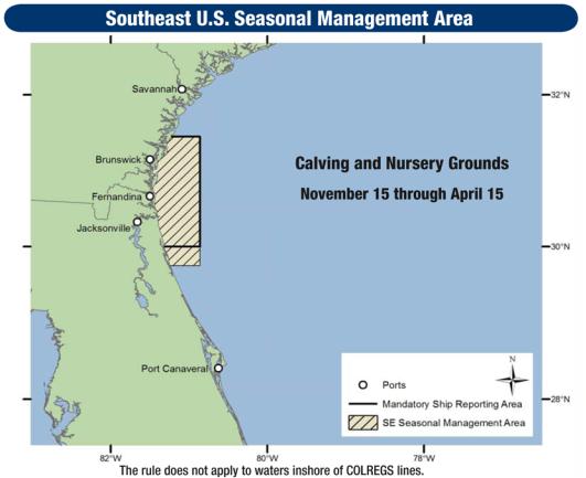
Calving and Nursery Ground
November 15 through April 15
Vessel speed is restricted in the area bounded to the north by latitude 31°27′N; to the south by latitude 29°45′N; to the east by longitude 080°51′36″W.
Temporary Dynamic Management Areas (DMAs) may also be established by NOAA Fisheries Service. Mariners are encouraged to avoid these areas or travel at 10 knots or less while transiting through these areas. NOAA Fisheries Service will announce DMAs to mariners through its customary maritime communication media.
I-1.35
NM 1/15 |
SECTION I |
(32) ENDANGERED SPECIES (WHALES AND SEA TURTLES) EASTERN SEABOARD. (Continued).
NOAA FISHERIES SERVICE
Mandatory speed restrictions of 10 knots or less are required in Seasonal Management Areas along the U.S. East Coast during times when right whales are likely to be present. The purpose of this regulation is to reduce the likelihood of deaths and serious injuries to these endangered whales that result from collisions with ships.
Vessels may operate at a speed greater than 10 knots only if necessary to maintain a safe maneuvering speed in an area where conditions severely restrict vessel maneuverability as determined by the pilot or master.
If a deviation from the 10 knot speed restriction is necessary, the following information must be entered into the vessel’s logbook:
-Reasons for deviation
-Speed at which vessel is operated
-Latitude and longitude at time of deviation
-Time and duration of deviation
-Master of the vessel shall sign and date the logbook entry
(Supersedes NTM 1(32)14) |
(NOAA) |
(33) REPORTING DEPTH INFORMATION.
The many ships presently equipped with reliable depth recorders constitute a potential wealth of sounding data desired by charting agencies for the purpose of confirming charted depths or charting heretofore unknown depths. While oceanographic survey vessels remain the primary source of bathymetric data, depth recordings submitted by navy, coast guard and merchant vessels will make an important contribution to the vital task of charting the oceans.
Mariners are encouraged to obtain and report soundings whenever bridge routine and equipment capabilities will allow. The American Practical Navigator (Bowditch) (PUB9), Sections 2911-2916 describes the bathymetric requirements and provides some guidance for observing and reporting sonic soundings. However, soundings must be correlated to positions and accompanied by supportive data such as:
(a)Detailed position/time information.
(b)Mariner’s own evaluation of positional accuracy (type of navigational system used and frequency of fixes).
(c)Ship’s course and speed with time of changes noted.
(d)Echogram scales in use and graduated scales provided, with time of scale changes.
(e)Draft of vessel and whether zero reference is corrected for draft.
(f)Regular annotations of date/time marks on echograms to enable correlation with positions.
(g)State of the tide and weather conditions.
(h)Other related information considered appropriate.
An uncharted depth of 15 fathoms/28 meters or less should be considered an urgent danger to navigation, and should be reported via radio without delay. Follow up with substantiating evidence, including the echogram, track chart and/or position log and all relevant navigational data and forward to NGA at the earliest opportunity.
Charts submitted to amplify a sounding report will be replaced, on request, with a new chart, except that foreign charts will be replaced with the equivalent U.S. chart, if available. Data reports and charts should be sent to the National GeospatialIntelligence Agency, Mail Stop N64-SH, 7500 Geoint Dr., Springfield, VA 22150-7500, either directly by mail or via any U.S.
Consulate. |
|
(Repetition NTM 1(33)14) |
(NGA/SHG) |
(34) WARNING-MINED AREAS.
Mines of various types and ages pose a threat to navigation in many parts of the world. Once mined, an area can never be certified to be completely danger free. Sweeping produces only statistical probability of protection. Mines may still remain, having failed to respond to orthodox sweeping methods. Some swept areas have not been covered by modern surveys and may contain uncharted wrecks, shoals or other dangers to navigation.
I-1.36
SECTION I |
NM 1/15 |
(34) WARNING-MINED AREAS. (Continued).
Prudent seamanship in former mine fields, swept channels and swept areas includes:
(a)Transit using only established routes or buoyed channels.
(b)Avoid shallow water. Sweeping techniques often preclude sweeping in restricted waters.
(c)Avoid fishing, trawling or any other form of submarine or seabed activity.
(d)Mariners are advised to anchor with caution only in established anchorages.
(e)Consult local authorities and regulations.
(Repetition NTM 1(34)14) |
(U.S. NAVY) |
(35) MINED AREAS REPORTED.
Minefields-Tarabulus, Libya.
In early 1973 Libya reported that the following areas had been mined. Although these areas are probably no longer a mine threat, they still represent a potential hazard to navigation. The areas reported by Libya are bounded by lines joining the
following positions: |
|
1. (a) 32°52'48''N., 13°24'30''E. |
2. (a) 32°53'42''N., 13°20'36''E. |
(b) 32°57'42''N., 13°24'30''E. |
(b) 32°55'54''N., 13°18'00''E. |
(c) 32°57'42''N., 13°18'00''E. |
(c) 32°55'54''N., 13°15'00''E. |
(d) 32°53'48''N., 13°22'18''E. |
(d) 32°54'30''N., 13°15'00''E. |
(Repetition NTM 1(35)14) |
(U.S. NAVY) |
(36) MINESWEEPING-CAUTION-ATTENTION IS CALLED TO THE FOLLOWING INSTRUCTIONS.
Minesweeping Operations:
(a)United States vessels engaged in minesweeping operations or exercises are hampered to a considerable extent in their maneuvering powers. Other Vessels Must Keep Clear of Minesweepers (COLREGS 1972).
(b)With a view to indicating the nature of the work on which they are engaged, these vessels will show the signals hereinafter mentioned. For the public safety, all other vessels, whether steamers or sailing craft, must endeavor to keep out of the way of vessels displaying these signals and not approach them inside the distances mentioned herein, especially remembering that it is dangerous to pass between the vessels of a pair or group sweeping together.
(c)All vessels towing sweeps are to show:
BY DAY.-A black ball at the fore mast and a black ball at the end of each fore yard. BY NIGHT.-All around green lights instead of the black balls, and in a similar manner.
(d)Vessels or formations showing these signals are not to be approached nearer than 1,000 meters on either beam and vessels are not to cross astern closer than 1,000 meters. Under no circumstances is a vessel to pass through a formation of minesweepers.
(e)Minesweepers should be prepared to warn merchant vessels which persist in approaching too close by means of any of the appropriate signals from the International Code of Signals.
(f)In fog, mist, falling snow, heavy rainstorms, or any other conditions similarly restricting visibility, whether by day or night, minesweepers while towing sweeps when in the vicinity of other vessels will sound signals for a vessel towing (1 prolonged blast followed by 2 short blasts).
Helicopters Conducting Minesweeping Operations:
(a)The United States is increasingly employing helicopters to conduct minesweeping operations or exercises. When so engaged, helicopters, like vessels, are considerably hampered in their ability to maneuver. Accordingly, surface craft approaching helicopters engaged in minesweeping operations should take safety precautions similar to those described in
(b) and (d) above with respect to minesweeping vessels.
(b)Helicopters towing minesweeping gear and accompanying surface escorts, if any, will use all available means to warn approaching ships of the operations or exercises being conducted. Also, measures will be taken where practicable to mark or light the gear or objects being towed.
(c)Minesweeping helicopters are equipped with a rotating beacon which has selectable red and amber modes. The amber mode is used during towing operations to notify/warn other vessels that the helicopter is towing. While towing, the helicopter’s altitude varies from 15 to 95 meters above the water and speeds vary from 0 to 30 knots.
I-1.37
NM 1/15 |
SECTION I |
(36)MINESWEEPING-CAUTION-ATTENTION IS CALLED TO THE FOLLOWING INSTRUCTIONS (Continued).
(d)General descriptions and approximate dimensions for towed minesweeping gear currently being used in conjunction with helicopters are as follows:
(1)Mechanical sweep gear consisting, in part, of large lengths of submerged cables and explosive cutters. The only items normally visible on the surface are three to five international orange floats, depending upon the quantity of gear in use, which generally define the dimensions of the tow. The maximum width is 100 meters and the maximum distance behind the helicopter is 600 meters.
(2)Acoustical sweep device weighing approximately 70 pounds. This device is towed behind the helicopter on a 250meter orange polypropylene tow cable. When dead in the water, the gear will rise to the surface, supported by a yellow float.
(3)A hydrofoil platform containing equipment used for magnetic influence sweeping. The platform is towed on the end of a 140-meter cable and trails electrodes in the water which extend 185 meters behind the platform. Very often, the aforementioned acoustical sweep device is towed in conjunction with this platform by attaching it to the end of one of the electrodes by a 30-meter polypropylene tow line. In this configuration, the total length of the tow is 215 and 350 meters, respectively, behind the hydrofoil platform and helicopter. Special care must be exercised when crossing astern of the hydrofoil platform as the towed cable is barely visible, and the attached acoustic device is submerged just beneath the surface and is not visible to surface vessels.
(4)Helicopters employed in minesweeping operations and their tows may function during the day, and in various types of weather conditions. The major danger to any surface vessel is getting the various cables wrapped in its screws.
Small craft also are subject to the risk of collision with the hydrofoil platform. |
|
(Repetition NTM 1(36)14) |
(U.S. NAVY) |
(37) UNITED STATES-EXPLOSIVE ORDNANCE-WARNING-GENERAL.
The continental shelf of the United States contains many forms of unexploded ordnance (military weapons), and while some ordnance hazard areas are designated, many unexploded ordnance locations are not known. The types most likely to be encountered are underwater ordnance (weapons) such as torpedoes, mines, depth charges, and aerial bombs, but other ordnance items may be found. In general, any metallic object having fins, vanes, propellers, horns, or possibly plates screwed or bolted to an external surface should be regarded as dangerous. This warning is published for all shipmasters, trawlers, fishermen, divers or persons conducting operations on or near the ocean bottom, and provides instructions on the action to be taken when ordnance items or suspicious objects are encountered:
(1) OBJECTS SNAGGED OR NETTED: Any object which cannot be immediately identified as a non-explosive (inert) item MUST BE TREATED AS AN EXPLOSIVE ITEM. If in any doubt about its identity, TREAT IT AS EXPLOSIVE. Nonexplosive naval ordnance items such as practice torpedoes and practice mines will normally be painted bright orange, for ready identification. Any object which is not painted orange may be dangerous and possibly can explode if brought on board or bumped in any way. If an object is brought to the surface of the water and it cannot be immediately identified as an inert item, DO NOT ATTEMPT TO BRING IT ON BOARD OR ALONGSIDE. If possible, release the object immediately and radio the nearest Navy or Coast Guard activity giving position and description of the object. If the object cannot be released, or freed by cutting net or line, the following actions are advised:
(a)stream object as far aft as possible;
(b)notify nearest Navy or Coast Guard activity and stand by for instructions or help;
(c)position crew at forward end of vessel, keeping deckhouse between them and the object astern; exposed personnel should remain under cover if possible;
(d)maintain steerageway as necessary to stay in the area until help or instructions arrive.
If unable to stand by while waiting for instructions because of deteriorating weather or sea conditions or other uncontrollable factors, keep the Navy or Coast Guard activity informed of your vessel’s position AND AVOID POPULATED AREAS, OTHER VESSELS, OR SHOREOR SEA-BASED STRUCTURES.
(2)OBJECTS BROUGHT ON BOARD: If a suspected explosive object is not detected until trawl or net contents have been discharged on board the vessel, take the following actions:
(a)avoid any bump or shock to the object;
(b)secure it in place against movement;
(c)keep it covered up and wet down;
(d)radio nearest Navy or Coast Guard activity and standby for instructions.
If unable to stand by while waiting for instructions because of deteriorating weather or sea conditions or other uncontrollable factors, keep the Navy or Coast Guard activity informed of your vessel’s position AND AVOID POPULATED AREAS, OTHER VESSELS, OR SHORE-OR SEA-BASED STRUCTURES.
I-1.38
SECTION I |
NM 1/15 |
(37) UNITED STATES-EXPLOSIVE ORDNANCE-WARNING-GENERAL. (Continued).
(3)FLOATING OBJECTS: If a floating object cannot be readily identified as non-explosive, IT MUST BE CONSIDERED TO BE EXPLOSIVE. DO NOT APPROACH, OR ATTEMPT TO RECOVER OR BRING ON BOARD. Report location immediately to the nearest Navy or Coast Guard activity and warn all other ships or craft in the vicinity. Try to keep the object in sight until instructions are received.
(4)NAVAL MINES: Naval mines constitute a risk to shipping, fishing, underwater exploration, and other maritime interests. The different types of mines, the conditions under which they are most likely to be sighted, and the recommended action are as follows:
FLOATING MINESConsider all floating mines to be live and dangerous. DO NOT TOUCH OR APPROACH. The possibility of drifting mines being camouflaged with seaweed or other innocent appearing floating objects should be borne in mind and avoiding action taken. The following procedures and precautions are recommended:
GROUND MINESON THE HIGH SEAS. Report the location of the mine by the most rapid means as soon as circumstances permit, this report is to be similar to that required for any hazard to navigation (See para 5). Mines sighted in anchorage areas or other patrolled water should, if circumstances permit, be kept under observation and reported to the nearest Navy or Coast Guard activity (See para 5). The recovery or handling of the mine should be done only by qualified explosive ordnance disposal personnel. If a mine is drifting down on a vessel at anchor and it cannot be avoided by other means, it is recommended that a stream of water from a fire hose be played near the mine to force it away from the vessel. WARNING: Mines may explode if a stream of water is played near them. Exposed personnel should remain under cover until danger is past.
MOORED MINESMoored mines may sometimes be seen several feet under the surface if the water is clear, or the mine may be floating on the surface. Often several mines or even a long row of the mines can be seen. Usually the sighting of one or more such mines indicates the presence of a minefield. Approaching the general vicinity of such mines is dangerous and should not ordinarily be undertaken by vessels. When mines are sighted, the location of the mines should be determined as accurately as possible, the area should be buoyed if this is feasible, all ships in the vicinity should be warned, and the appropriate Navy or Coast Guard activity should be notified immediately. Ground mines are normally laid in water so deep that they will not be seen unless the water is very clear. However, in very clear water with a hard white sand bottom, even a camouflaged mine can often be located because of the long, regular shadow it casts. The sighting of such a mine may indicate a minefield in the neighborhood. Approaching the general vicinity of such a mine is very dangerous. If a mine is sighted, the location should be determined as accurately as possible and buoyed, all ships in the vicinity should be warned, and the appropriate Navy or Coast Guard activity should be notified immediately.
BEACHED MINESAny of the above types of mine may be found on the beach, either thrown up by the waves or mislaid by aircraft. Any mine found beached or floating close inshore should be reported at once to the nearest Navy, Coast Guard, military, or civil authority, and the mine should be kept under guard until the arrival of responsible authorities. No person except qualified explosive ordnance disposal personnel should be allowed closer than 400 yards.
(5)REPORTING OF SUSPICIOUS OBJECTS RESEMBLING MINES: Ships frequently report objects resembling mines but give insufficient information to properly evaluate the reports. As a result, needless time and expense is incurred only to find that they are not mines but other floating objects. HOWEVER, VESSELS SHOULD NOT ATTEMPT TO RECOVER OBJECTS RESEMBLING MINES OR PASS CLOSE ABOARD FOR POSITIVE IDENTIFICATIONKEEP WELL CLEAR. Since mines are a danger to life and property at sea, masters of ships sighting unidentified or suspicious objects are requested to furnish the following information to the nearest Navy or Coast Guard radio station or activity:
(a)Position of object, and how closely it was approached.
(b)Size, shape, condition of painting, and the presence of marine growth.
(c)Whether or not horns or rings are attached.
(d)Whether or not definite identification possible.
(Repetition NTM 1(37)14) |
(U.S. NAVY) |
(38) CAUTION-OIL WELL STRUCTURES IN WATERS CONTIGUOUS TO THE U.S. AND ITS TERRITORIES.
Caution should be exercised when navigating in the waters contiguous to the U.S. and its territories particularly in the Gulf of Mexico, Santa Barbara Channel, California, and Cook Inlet, Alaska, in order to avoid collision with oil well structures and their associated mooring piles, anchor and mooring buoys, etc.
I-1.39
NM 1/15 |
SECTION I |
(38)CAUTION-OIL WELL STRUCTURES IN WATERS CONTIGUOUS TO THE U.S. AND ITS TERRITORIES. (Continued).
In general, oil well structures can be identified at night by the display of one or more quick flashing white or red lights, however, ships can expect to encounter unlighted structures as well. Structures may be equipped with a fog signal consisting of a horn sounding one 2-second blast every 20 seconds. Submerged wells may be marked by lighted or unlighted buoys.
Shipping safety fairways have been established through the concentration of oil wells in the Gulf of Mexico and Santa Barbara Channel. Mariners are encouraged to use these fairways and should avoid anchoring within a safety fairway. Certain
areas adjacent to shipping safety fairways have been charted as fairway anchorages. |
|
(Repetition NTM 1(38)14) |
(USCG) |
(39) CAUTION REGARDING APPROACH OF SINGLE VESSELS TOWARD NAVAL FORMATIONS AND |
|
CONVOYS. |
|
A formation of warships or a convoy is more difficult to maneuver than a single ship. Therefore, the attention of masters is called to the danger of all concerned which is caused by a single vessel approaching a formation of warships or convoy so closely as to involve risk of collision, or attempting to pass ahead of, or through such a formation or convoy. All ships are therefore cautioned to employ the customary manners of good seamanship and, where there is ample sea room, adopt early measures to keep out of the way of a formation of warships or convoy. The fact that in the interests of safety a single vessel should keep out of the way of a formation or convoy does not entitle vessels sailing in company to proceed without regard to the movements of the single vessel. Vessels sailing in formation or convoy should accordingly keep a careful watch on the movements of any single vessel approaching the squadron or convoy and should be ready, in the case the single vessel does not
keep out of the way, to take such action as will best aid to avert collision. |
|
(Repetition NTM 1(39)14) |
(U.S. NAVY) |
(40) NATIONAL GEOSPATIAL-INTELLIGENCE AGENCY DISTRIBUTION SYSTEM.
GENERAL INFORMATION AND CUSTOMER ORDERING GUIDANCE.
DEFENSE LOGISTICS AGENCY FOR AVIATION-MAPPING CUSTOMER OPERATIONS (DSCR-QAM).
The Defense Logistics Agency for Aviation is available to assist customers during normal duty hours, Monday through Friday, 0730 to 1730 (except holidays) Eastern Time. After hours messages are recorded for processing on the next business day. The office can respond to inquiries regarding catalog usage, ordering procedures, product availability, disposition of excess stock, subscriptions and many other GGI&S related activities and interests.
Mailing Address:
Defense Logistics Agency for Aviation
Mapping Customer Operations (DSCR-QAM)
8000 Jefferson Davis Highway
Richmond, VA 23297-5339
Message Address:
DSCR RICHMOND VA//DSCR-FAN// DSN: 695-6500; Fax: 695-6510
Tel: (804) 279-6500; Fax: (804) 279-6510 Toll Free: 1-800-826-0342
E-mail: Mapping Customer Operations Email Form: http://www.aviation.dla.mil/rmf/webmaster/hydroEmail.htm Web site: www.aviation.dla.mil/rmf/
After Normal Duty Hours and Crisis Support
Pager-DSCR-QAM Duty Officer: Tel. (804) 279-6500
DSN 695-6500
Toll Free 1-800-826-0342
NATIONAL GEOSPATIAL-INTELLIGENCE AGENCY (NGA) OFFICE OF CORPORATE COMMUNICATIONS.
The NGA Office of Corporate Communications is the point of contact for public queries. Phone: 571-557-5400. For assistance with NGA products and services, E-mail: queries1@nga.mil.
I-1.40