

NP100 Edition 9 2009
.pdfSafetyNET. METAREA I only (i.e. area outside NAVTEX coverage). For full broadcast details see
Admiralty List of Radio Signals Volumes 3 and 5.
Coastal Inshore Waters Forecast
4.21
Coastal Inshore Waters Forecasts are broadcast for the benefit of coastal shipping, fishing vessels and leisure craft, covering the coastal waters of the UK out to 12 miles. They provide a brief synopsis, 24 hour forecast and a 24 hour outlook for 17 coastal areas.
Note. The Shetland Isles inshore forecast covers a 60 mile range of Lerwick and consists of a 12 hour forecast and a 12 hour outlook.
Promulgation. Coastal Inshore Waters Forecasts are broadcast through:
VHF by HM Coastguard MRCCs in the United Kingdom;
National NAVTEX Service (490 kHz); BBC Radio 4.
For full broadcast details see Admiralty List of Radio Signals Volume 3.
Coastal Strong Wind Warnings
4.22
Coastal Strong Wind Warnings will only be issued if the wind speed in an inshore waters forecast area is forecast at Force 6 or more and was not identified in the previous inshore waters forecast. These will be broadcast on receipt and may be included in the
Contents
repetition broadcast and are valid until the next new inshore waters forecast. The legend ‘SWW’ will be included in the Inshore Forecast if winds are forecasted at Force 6 or more to indicate that a strong wind warning is in operation for the time covered by the forecast.
Promulgation. Coastal Strong Wind Warnings are broadcast on receipt through VHF by HM Coastguard MRCCs in the United Kingdom and also on the National NAVTEX Service (490 kHz). For full broadcast details see Admiralty List of Radio Signals Volume 3.
Ships’ Weather Reports
4.23
Ships’ Weather Reports are made from vessels which have been recruited by National Meteorological Services to participate in the WMO Voluntary Observing Ship Scheme. Full details are given in
Admiralty List of Radio Signals Volume 3.
They can be sent through a specified Inmarsat Land Earth Station using Special Access Code 41 of Inmarsat–B or Inmarsat–C. For full Inmarsat details see Admiralty List of Radio Signals Volumes 1 and 5.
Met Office website
4.24
Latest marine observations; shipping forecasts and gale warnings; and inshore waters forecasts and strong wind warnings can also be found on the Met Office website at www.metoffice.gov.uk
Admiralty Notices to Mariners
Promulgation
How Notices to Mariners are promulgated
4.25
Weekly Editions of Admiralty Notices to Mariners contain information which enables the mariner to keep charts and books published by the UKHO up–to–date for the latest reports received.
The Notices are published in Weekly Editions, and are also issued by the UKHO on a daily basis to certain Admiralty Distributors.
Weekly Editions can either be obtained from Admiralty Distributors, or by regularly despatched surface or air mail.
4.26
Internet Services. Admiralty Notices to Mariners are also available on the Internet, using the Admiralty Notices to Mariners On–Line (ANMO) service. The ANMO service provides the digital versions of the weekly Notices to Mariners Bulletin, Full–Colour Blocks, Cumulative List of Admiralty Notices to Mariners and Annual Summary of Notices to Mariners. This service is available by following the Maritime Safety Information link at www.ukho.gov.uk. The web service is in Adobe Acrobat/PDF format, and the latest version of the software, and guidance notes, are available from the NM section of the website. There is also a searchable service which allows mariners to search for Notices by Admiralty Chart number. This service is available at www.nmwebsearch.com
Electronic Courier Services. Further to the
Admiralty Notices to Mariners (ANMO) service on the UKHO website, the UKHO has licensed several commercial companies to electronically distribute
Admiralty Notices to Mariners via ‘L’ Band broadcast, or email communication, direct to vessels at sea. These ‘electronic courier’ or ‘value added service providers’ supply customised NM Text and Tracing update datasets related to a vessel’s portfolio of charts and publications. The NM datasets are derived directly from the Admiralty digital NM files.
Numbering conventions
4.27
Weekly Editions are consecutively numbered from the beginning of each calendar year. Notices to Mariners are also numbered consecutively starting at the beginning of the year, noting that Annual Notices to Mariners will always have the first numbers in each yearly series.
Types of Notice to Mariners
General information
4.28
The majority of information designed for use in correcting paper charts is promulgated by the UKHO in the form of permanent, chart–correcting notices. Under certain circumstances, however, alternative forms of Notice to Mariners are utilised.
61

Preliminary Notice to Mariners ((P)NM).
4.29
A (P)NM is used when early promulgation to the mariner is needed, and:
Action/work will shortly be taking place (e.g. harbour developments), or:
Information has been received, but it is too complex or extensive to be promulgated by permanent chart updating NM. A précis of the overall changes together with navigationally significant detailed information is given in the (P)NM. Full details are included in the next New Chart or New Edition, or:
Further confirmation of details is needed. A permanent chart updating NM will be promulgated or NE issued when the details have been confirmed, or:
For ongoing and changeable situations such as bridge construction across major waterways. A permanent chart updating NM will be promulgated or NE issued when the work is complete.
Temporary Notice to Mariners ((T)NM).
4.30
A (T)NM is used where the information will remain valid only for a limited period, but will not normally be initiated when the information will be valid for less than 3–6 months. In such circumstances, the information may be available as an Navigational Warning (4.8) or may be promulgated by means of a Local Notice to Mariners.
Structure of the Weekly Edition
of Notices to Mariners
Section I – Explanatory Notes and Publications List
4.31
Section I, published weekly, contains:
Notes and advice on the use, update and amendment of charts and publications.
Lists of New Charts, New Editions and Navigational Publications published, and any charts withdrawn, during the week.
Publication of New Charts or New Editions, or withdrawals, scheduled to take place in the near future.
Section IA. This section is published monthly and contains a list of (T) and (P) NMs cancelled during the previous month and a list of T&P Notices previously published and still in force.
Section IB. This section is published quarterly at the end of March, June, September and December each year. It lists the current editions of:
Admiralty Sailing Directions and their latest Supplements.
Admiralty List of Lights and Fog Signals. Admiralty List of Radio Signals.
Admiralty Tidal Publications.
Admiralty Digital Publications.
Contents
Section II – Updates to Standard Navigational Charts
4.32
Section II contains the permanent Admiralty chart updating Notices, the first of which is always a Notice containing Miscellaneous Updates to Charts. Notices based on original information, as opposed to those that republish information from another country, have their consecutive numbers suffixed by an asterisk. Any Temporary and Preliminary Notices are included at the end of the Section. They have their consecutive numbers suffixed (T) and (P) respectively. These Notices are preceded by a Geographical Index, an Index of Notices and Chart Folios and an Index of Charts Affected.
Blocks. Cautionary notes, depth tables and diagrams to accompany any of these Notices will be found at the end of the section (See also 2.75 and 3.4).
Section III – Reprints of Navigational Warnings
4.33
This section lists the serial numbers of all NAVAREA I messages in force with reprints of those issued during the week.
Section IV – Amendments to Admiralty Sailing Directions
4.34
This section contains amendments to Admiralty Sailing Directions (3.10) published during the week.
Note. The full text of all extant Section IV Notices is published annually in January in Annual Summary of Admiralty Notices to Mariners Part 2 – Amendments to Sailing Directions.
Section V – Amendments to Admiralty Lists of Lights and Fog Signals
4.35
This section contains amendments to Admiralty List of Lights and Fog Signals. These amendments may not be published in the same weekly Edition as those giving chart updating information in Section II.
Section VI – Amendments to Admiralty Lists of Radio Signals
4.36
This section contains amendments to the Admiralty List of Radio Signals. These amendments may not be in the same Weekly Edition as those giving chart updating information in Section II.
Note. A Cumulative List of Amendments to the current editions of the Admiralty List of Radio Signals is published in Section VI quarterly in March, June, September and December.
Maintenance of NM Data
Retention of back copies
4.37
To maintain an effective set of NM data, Weekly Editions should be retained dating back to the earliest publication date of the current volumes of Admiralty List of Lights and Fog Signals and Admiralty List of Radio Signals.
62

In the case of Admiralty Sailing Directions, corrections are reprinted in full in January each year in
Annual Summary of Notices to Mariners Part 2 (see below).
Annual Summary of Admiralty Notices to Mariners
4.38
Annual Summary of Admiralty Notices to Mariners is published annually in January, in two parts. The first part is in two sections:
Section I contains Annual Notices to Mariners. These Notices cover important topics which are likely to remain valid for some time and may be the same or very similar to those published in previous years. If and when it becomes apparent that the information has become more enduring than was originally envisaged, it will be transferred into the most appropriate parent publication.
Section II contains reprints of all Admiralty Temporary and Preliminary Notices which are in force on 1st January.
The second part is also in two sections: Section I lists the current editions of all volumes of
Admiralty Sailing Directions, and, where appropriate, their latest supplements.
Section II contains reprints of all extant amendments to Admiralty Sailing Directions which have been published in Section IV of Weekly Editions of Admiralty Notices to Mariners and are in force on 1st January.
These volumes are obtainable in the same way as other Admiralty Notices to Mariners.
Cumulative List of Admiralty Notices to Mariners
4.39
Cumulative List of Admiralty Notices to Mariners is published 6–monthly in January and July. It lists the publication dates of the current edition of each
Contents
Admiralty chart and those Australian (AUS), New Zealand (NZ) and Japanese (JP) charts republished in the Admiralty series, and the serial numbers of permanent Notices affecting them issued in the previous two years.
The quoted publication date may be that of a New Chart, New Edition or a large correction. The relevant date is given in the bottom outside margin of the chart.
Summary of periodical information
4.40
Annual Summary of Admiralty Notices to Mariners and Notices issued at regular intervals provide details of messages, updates and amendments in force.
The table shows where this information can be found.
Subject |
Serial Numbers |
Full text |
|
in force |
published |
|
published |
Annually in: |
|
Monthly in |
|
|
Weekly Edition |
|
|
Section: |
|
|
|
|
NAVAREA, |
III |
Weekly Edition |
HYDROPAC |
|
No. I |
and |
|
|
HYDROLANT |
|
|
messages |
|
|
Temporary and |
IA |
Annual |
Preliminary |
|
Summary Part 1 |
Notices |
|
|
|
|
|
Amendments to |
IV |
Annual |
Admiralty Sailing |
|
Summary Part II |
Directions |
|
|
|
|
|
Amendments to |
VI |
List published |
Admiralty List of |
|
Quarterly |
Radio Signals |
|
|
|
|
|
Reporting of information
Observing and reporting hydrographic information
General remarks
4.41
Ever since man ventured on the sea, mariners have depended upon the experience and reports of those who sailed before; in this way, through the years, an increasing amount of information was accumulated from seafarers and explorers until it became possible to set down the details in convenient form, which was on charts and in Sailing Directions.
It may be true to say that there are now no undiscovered lands or seas and that most coasts have, to a greater or lesser degree, been surveyed and mapped; yet it is equally true that the accuracy of charts and their associated publications depend just as much as ever on reports from sea, and from others who are responsible for inshore surveys, lights, and other aids to navigation. Without a supply of
information from these sources, it would not be possible to keep the charts and publications corrected for new and changed conditions.
Whenever a ship is making good a track over a portion of the chart where no soundings are shown, or over an area of suspected shoal depths, it is advisable to take soundings. If the ship is fitted with a suitable echo sounder, such soundings if properly recorded and reported, will be of much value for the subsequent improvement of the chart.
The planning of surveys can be considerably assisted by reports from ships on the adequacy or otherwise of existing charts, particularly in the light of new or intended developments at a port. In this connection the views of Harbour Authorities and pilots can be of value.
Opportunities for reporting
4.42
Subject to compliance with the provisions of international law concerning innocent passage, or to national laws where appropriate, every mariner should
63

endeavour to note where charts and publications disagree with fact and should report any differences to the UKHO. Statements confirming charted and published information which may be old, but nevertheless correct, are of considerable value and can be used to reassure other mariners visiting the area.
It is hoped that the mariner, by following the points mentioned below, will be able to make best use of the opportunities with which he is often presented to report information, though it is realised that all ships do not carry the same facilities and equipment.
Reports which cannot be confirmed, or are lacking in certain details, should not be withheld. Shortcomings should be stressed, and any firm expectation of being able to check the information on a succeeding voyage should be mentioned.
Obligatory reports
Requirements
4.43
The International Convention for the Safety of Life at Sea (SOLAS), 1974, requires the Master of every vessel which meets with any of the following to make a report:
Dangerous ice, or air temperatures below freezing associated with gale force winds causing severe icing. See NP 100 6.49 for details of the required content of the report.
A dangerous derelict. The report should include the nature of derelict or danger, its position when last observed, and the date and time when it was last observed, using UT (GMT).
Any other danger to navigation. These may include shoal soundings, uncharted dangers and navigational aids out of order. Such dangers should also be reported to the UKHO, Navigational Warnings, by telephone (+44(0)1823 353448), Fax: (+44(0)1823 322352), Telex 46464 or email at navwarnings@btconnect.com. The draught of modern tankers is such that any uncharted depth
of |
less than 30 m may be of sufficient importance |
|
to |
justify |
such action. |
A tropical |
storm, or winds of Force 10 and above |
|
of which there has been no warning. See NP 100 7.28 for details of the required content of the report.
The report is to be made by all means available to vessels in the vicinity, and to the nearest coast radio station or signal station. It should be sent, preferably in English, or by The International Code of Signals. If sent by VHF or MF all safety communications should consist of an announcement, known as a Safety Call Format, transmitted using DSC or RT, followed by the safety message transmitted using RT. The message should be preceded by the safety signal SECURITE (for safety) or PAN PAN (for urgency) and repeated in each case three times. Full details can be found in
Admiralty List of Radio Signals Volume 5.
In cases where it is considered that urgent charting action may be required, it is recommended that such reports be copied to the UKHO by the most appropriate means.
These reports are obligatory for the Masters of ships registered in the United Kingdom, under
Contents
Statutory Instrument No 534 of 1980 and No 406 of 1981.
Standard reporting format and procedures
4.44
IMO Resolution A.648(16) introduces a standard reporting format and procedures, which are designed to assist Masters making reports in accordance with the national or local requirements of different Ship Reporting Systems.
Vessel movements are reported through a Sailing Plan, sent prior to departure, Deviation Reports where the vessel’s position varies significantly from that predicted and a Final Report on arrival at destination or when leaving a Reporting Area. Three other standard reports give the detailed requirements for reporting incidents involving dangerous goods, harmful substances and marine pollution.
The existing procedure for making the obligatory reports described in 4.43 remains unaltered.
Other forms of report
Hydrographic Note
4.45
The Hydrographic Note (Form H102) is the preferred vehicle for submission of information, to the UKHO relating to charts and publications. This form is reproduced at the end of this chapter, and includes detailed guidance on its completion. Additionally, blank copies of the form are printed at the back of each weekly edition of Admiralty Notices to Mariners. They can also be obtained free of charge from any Admiralty Distributor, and can be downloaded from the UKHO website www.ukho.gov.uk.
In addition, the following UKHO forms are used for specific purposes:
Form H102a, Hydrographic Note for Port Information, should be used to render reports on port and harbour information. It is reproduced at the end of this chapter, and may be otherwise obtained in exactly the same way as the H102 above.
Form H102b, Hydrographic Note for GPS Observations against Corresponding Chart Positions, should be used for rendering reports in accordance with para 4.52. It is also reproduced at the end of this chapter, and may be downloaded from the UKHO website.
Form H636, Marine Bioluminescence Observations Reporting Form. See 4.68.
Mariners should not be deterred from reporting if any of the above forms are not to hand. Manuscript or email is just as acceptable.
Irrespective of format, reports should be forwarded
to the UKHO, |
Admiralty |
Way, Taunton, |
Somerset, |
TA1 2DN, |
United |
Kingdom |
(email: |
hdcfiles@ukho.gov.uk).
In addition to the foregoing, mariners can assist the UKHO to provide the latest details of maritime radio services by supplying new, additional or corroborative information for Admiralty List of Radio Signals, using the report form in the front of each volume of
Admiralty List of Radio Signals, or Form H.102. Such information can be forwarded, either in manuscript, or by email.
64

Information requiring corroboration
4.46
Some information, dependent on its source and completeness, will require corroboration from an authoritative source (e.g. primary charting authority or a port authority) before being acted upon. However, if corroboration is being sought, but the nature of the information is such that it needs to be promulgated urgently, an NM may be issued.
Such reports should always be followed by a completed Form H.102 giving all available information.
Positions
Charts
4.47
The largest scale chart available, a plotting sheet prepared to a suitable scale, or, for oceanic soundings, an ocean plotting sheet (2.48), should be used to plot the ship’s position during observations.
A cutting from a chart, with the alterations or additions shown in red, is often the best way of forwarding detail. If required, a replacement for a chart used for forwarding information will be supplied gratis. If it is preferred to show the amendments on a tracing of the chart, rather than on the chart itself, they should be shown in red, but adequate detail from the chart must be traced in black to enable the tracing to be fitted correctly.
The chart used should be stated and described as at 2.41.
Geographical positions
4.48
Latitude and longitude should only be used specifically to position details when they have been fixed by astronomical observations or by a position–fixing system which reads out in latitude and longitude.
Astronomical positions
4.49
Observations should be accompanied by the names and altitudes of the heavenly bodies, and the times of the observations. A note of any corrections not already applied, and an estimate of any probable error due to conditions prevailing at the time, should also be included.
Visual fixes
4.50
To ensure the greatest accuracy, a fix defined by horizontal sextant angles, compass bearings (true or magnetic being specified), or ranges, should consist if possible of more than two observations. The observations should be taken as nearly as possible simultaneously, should be carefully recorded at the time and listed in the report with any corrections that have been applied to them.
Fixes from electronic positioning systems
4.51
Loran–C positions should be accompanied by the time and full details of the fixes obtained. It should also be stated whether any corrections have been applied, and if so their values.
Contents
Fixes from GPS
4.52
The report should include information on whether the receiver was set to WGS84 Datum or was outputting positions referred to another datum, or whether any position shifts quoted on the chart have been applied. Extra information such as the receiver model, and Dilution of Position values (Indications of theoretical quality of position fixing depending upon the distribution of satellites – PDOP, HDOP and GDOP) should be supplied if available.
Mariners are requested to report observed differences between positions referenced to chart graticule and those from GPS, referenced to WGS84 Datum, using Form H.102b (Form for Recording GPS Observations and Corresponding Chart Positions) reproduced at the end of this chapter. The results of these observations are examined and may provide evidence for notes detailing approximate differences between WGS84 Datum and the datum of the chart.
Channels and passages
4.53
When information is reported about one shore of a channel or passage, or of an island in one, every endeavour should be made to obtain a connection between the two shores by angles, bearings or ranges.
Soundings
Echo sounder
4.54
The following information about the echo sounder should be included in the report.
Make, name and type of set.
The number of revolutions per minute of the stylus (checked by stop–watch).
Speed of sound in sea water in metres or fathoms per second equivalent to the stylus speed. Whether soundings have been corrected from
Echo–sounding Correction Tables.
Setting of the scale zero. That is whether depths recorded are from the sea surface or from the underside of the keel. If from the keel, the ship’s draught abreast the transducers at the time and the height of the transducers above the keel should be given.
Where the displacement of the transducers from the fixing position is appreciable, the amount of this displacement and whether allowance has been made for it.
For methods of checking the accuracy of a sounder, see 11.102—11.103.
Trace
4.55
The trace should be forwarded with the report. To be used to full advantage, it should be marked as follows:
A line drawn across it each time a fix is taken, and at regular time intervals.
The times of each fix and alteration of course inserted, and times of interval marks at not more than 15 minute intervals.
The position of each fix and other recorded events inserted where possible, unless a GPS printout or
65

Contents
Marked up trace (4.55)
separate list of times and corresponding positions is enclosed with the report.
The recorded depths of all peak soundings inserted.
The limits of the phase or scale range in which the set is running marked, noting particularly when a change is made.
Name of the ship, date, zone time used and scale reading of the shoalest edge of the transmission line should be marked on the trace.
Diagram 4.55 shows a specimen trace with all the information required.
Navigational marks
Lights
4.59
The simplest way to ensure a full report on lights is to follow the columns in the Admiralty List of Lights giving the information required under each heading. Some details may have to be omitted for lack of data
whilst it may be possible to amplify others. Characteristics should be checked with a stop–watch.
Buoys
4.60
Details of buoys shown on the largest scale chart and given in Admiralty Sailing Directions should be verified. The position of a buoy should be checked, where possible, by fixing the ship and taking a range and bearing to the buoy, or by another suitable method.
Beacons and daymarks
4.61
New marks should be fixed from seaward, and the position verified where possible by responsible authorities in the area, who should be quoted in the report.
Conspicuous objects
4.62
Reports on conspicuous objects are required frequently since objects which were once conspicuous
66

may later become obscured or made less conspicuous by new buildings, vegetation or other developments. The positions of conspicuous objects can sometimes be obtained from local authorities, but more often will need to be be fixed, like the new marks above, from seaward.
Wrecks
4.63
Stranded wrecks (which are wrecks any part of whose hull dries) or wrecks which dry should be fixed by the best available method and details recorded. The measured or estimated height of a wreck above water, or the amount which it dries, should be noted. The direction of heading and the extremities of large wrecks should be fixed if the scale of the chart is sufficiently large.
Tidal streams
Reporting
4.64
Reports of unexpected tidal streams should be obtained wherever possible. If only a general description of the direction can be given, it is preferable to use terms such as “east–going” and “west–going”, rather than “flood” and “ebb” streams which can be ambiguous.
The time of the change of stream should always be referred to the time of local high water, or if this in not known, to the time of high water at the nearest port for which predictions are given in Admiralty Tide Tables.
Port facilities
General information
4.65
Form H.102a is designed as an aide–memoire for checking and collecting port information, and for rendering with Form H.102.
When opportunity occurs, Sailing Directions should be checked for inaccuracies, out–of–date information and omissions. Port regulations, pilotage, berthing provisions and water and other facilities are frequently subject to change. It is often only by reports from visitors that charts and publications can be kept up–to–date for such information. The value of such reports is enhanced if they can be accompanied by the local Port Handbook or a point of contact for further information.
When dredging operations or building work, such as that on breakwaters, wharves, docks and reclamations are described, a clear distinction should be made between work completed, work in progress, and work projected. An approximate date for the completion of unfinished or projected work is valuable.
Though all dimensions of piers or wharves are useful, the depths at the outer end and alongside are the most important items.
Where dredged channels exist, the date of the last dredging and the depth obtained should be reported if found to be different from those charted.
Contents
Offshore reports
Ocean currents
4.66
Much useful knowledge of ocean currents (see NP 100 5.1–5.11) can be obtained by ships on passage. Mariners should consider reporting unusual or exceptional currents encountered using a standard Hydrographic Note (4.45).
Discoloured water
4.67
The legend “discoloured water” (see NP 100 5.37) appears on many charts, particularly those of the Pacific Ocean where shoals rise with alarming abruptness from great depths. Most of these legends remain on the charts from the last century when very few deep sea soundings were available, and less was known of the causes of discoloured water. Only a few of the reports of discoloured water have proved on examination to be caused by shoals.
Today, such reports can be compared with the accumulated information for the area concerned, a more thorough assessment made, and as a result this legend is now seldom inserted on charts.
Mariners are therefore encouraged, whilst having due regard to the safety of their vessels, to approach sightings of discoloured water to find whether or not the discoloration is due to shoaling.
If there is good reason to suppose the discoloration is due to shoal water, a Hydrographic Note (4.45), accompanied by an echo sounder trace and any other supporting evidence, should be rendered. If there is no indication of a shoal, the report should be forwarded to the Met Office, Exeter, Devon EX1 3PB, and a copy sent to the UKHO.
Bioluminescence
4.68
Forms of bioluminescence are discussed at NP 100 5.38—5.39. Details required in reports are as follows:
Name of vessel and observer.
Date, time and period of day (for example; early evening, night, or dawn).
Position of sighting. Colour of phenomenon.
Description of phenomenon. Approximate extent of phenomenon. Means of stimulation (if any).
Reports should be rendered to the UKHO whenever possible. They can be submitted on a Form H636 Marine Bioluminescence Observations Reporting Form (H.636), reproduced at the end of this chapter or available from the Maritime Environment Information Centre at the UKHO, or made using a standard Hydrographic Note (4.45).
Underwater volcanoes and earthquakes
4.69
When tremors or shocks attributable to underwater volcanoes and earthquakes (see NP 100 5.40—5.41) are experienced, reports made to the UKHO, using a standard Hydrographic Note (4.45) or by radio, are of considerable value.
Reports should give a brief description of the occurrence, its time and date, the ship’s position, and the depth of water at that position.
67

Whales
4.70
Given the importance of cetacean conservation, reports of whales, porpoises and dolphins are of considerable interest.
For identifying species, useful publications are
Guide to the Identification of Whales, Dolphins and Porpoises in European Seas (by P G H Evans) and Whales, Dolphins and Porpoises — The visual guide to all the world’s cetaceans (by M Carwardine).
Details required in reports are as follows: Name of vessel and observer
Date, time and period of day (for example; early evening, night, or dawn).
Position of sighting
Identification and supportive description Number sighted
Reports should be rendered to the UKHO whenever possible. They should be submitted on a Form H.637 Marine Life Reporting Form, reproduced at the end of this chapter or available from the Maritime Environment Information Centre at the UKHO, or made using a standard Hydrographic Note (4.45).
Turtles in British waters
4.71
Reports detailing sightings of turtles are of considerable interest. For identifying species, a useful publication is The Turtle Code (by Scottish Natural Heritage).
Reports should be made and forwarded in the same way as those described above for whales.
Ornithology
4.72
Those interested in ornithology can often make useful additions to the existing knowledge of bird behaviour and migration; details required can be obtained from the Hon Secretary, RN Birdwatching Society, 19 Downland Way, South Wonston, Winchester, Hants SO21 3HS.
Magnetic variation
Reporting
4.73
In many parts of the world there is a continuous need for more data for the plotting of isogonic curves on Admiralty Magnetic Variation charts.
All observations are valuable, but there is a particular requirement for data S of latitude 40°S, or in areas where the isogonic curves are close together, or where there are local magnetic anomalies (see NP 100 11.3).
Form H.488 — Record of Observations for Variation is reproduced on page 81 and can be obtained from the UKHO, is designed for rendering these observations. The methodology is described on the back of the form.
Local magnetic anomalies. Whenever a ship passes over a local magnetic anomaly (see NP 100 11.3), the position, extent of the anomaly, and the amount and direction of the deflection of the compass needle, should be reported, or confirmed if it is already charted, on Form H.102 to the UKHO.
Contents
Views
Introduction
4.74
The general availability of modern aids to navigation has reduced the need for long–range coastal views for landfalls and coastal passages, although this remains just as important for vessels not fitted with an electronic–position–fixing system or GNSS. However, the need to change from instrument to visual navigation still occurs at some stage for all mariners, and good views are still invaluable for the speedy recognition of features when making this change.
New photographs are always welcome, particularly where views published in Admiralty Sailing Directions or on Admiralty charts are out–of–date or inadequate, or where a new view would assist the mariner. Photographs should only be taken if circumstances permit and are not forbidden by national regulations.
The following information is provided to rationalise the requirement for views and to assist the mariner in providing pictures which will be of most use both to other mariners and to the compilers and editors of charts and Sailing Directions, and in a usable format.
Even if it is not possible to comply precisely with the following guidelines, it should be borne in mind that even an imperfect photograph, correctly annotated, may well be useful in producing a view which could be of considerable value to the mariner. All material received is evaluated accordingly.
Types of view
4.75
The various types of view are given the following names.
Panoramic. A composite view made up from a series of overlapping photographs. This type of view is normally used to illustrate an aspect from offshore, including hinterland.
Aerial oblique. A single view taken from the air, which shows a combination of plan and elevation. Pilotage. A single or composite view from the approach course to a harbour or narrows, showing any leading marks or transits. It may be combined with a close–up of the mark if necessary for positive identification.
Portrait. A single view of a specific object, set against its salient background.
Close–up. A single view of one object or feature with emphasis on clarity of the subject for its identification.
Panoramic views
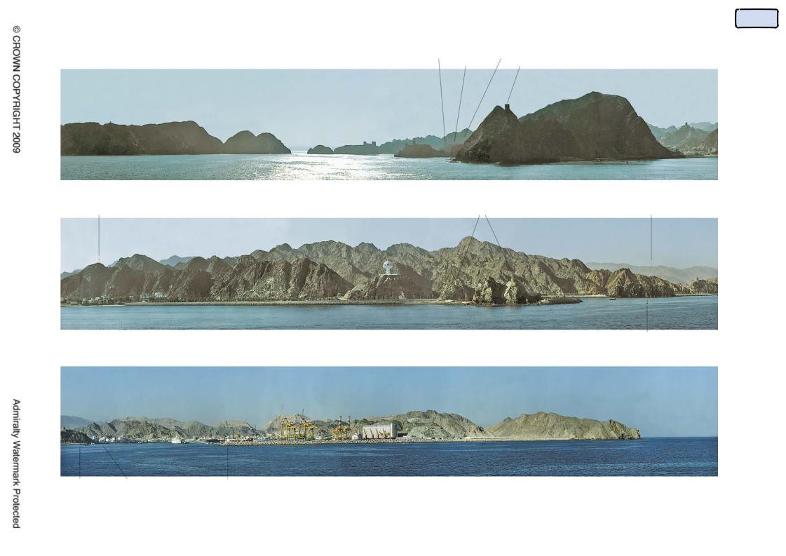
4.76
Panoramic views should include, whenever possible, an identifiable feature at either end so that its geographical limits are clearly defined (see view 4.76).
The following measures should be adopted where possible to maximise clarity of detail:
Using additional height to increase the vertical presentation;
Closing as near as prudent to the coast whilst retaining the offshore aspect;
Using a telescopic lens;
Taking a series of photographs, overlapping by 30%, that can be built–up into a panorama.
68
Contents
|
|
Sultan’s Palace |
Masqat |
Fl.12s.84m.14M |
Qal’at Jalali |
Hisar Mirami |
Tower |
Jazirat Masqat |
Sirat Al Gharbiyan |
Ra’s Kalbuh |
Fl.(2).R.10s |
Radio Mast |
Observation Tower |
Towers |
Tower Matrah Castle |
69
Kalbuh |
|
|
No 1 Q.R |
Matrah Castle |
Matrah |
Silos |
Ra’s ash Shutayfi |
No 2 FL.R.2s. No 3 FL.R.5s. |
FL.5s.9m. |
Ra’s Kowasir |
Gulf of Oman – Approaches to Muscat and Mutrah (Port Sultan Qabas) (4.76)

Contents
Grangemouth Docks from NE (4.77.1)
(Original dated 1997)
(Photograph – Aerial Reconnaissance) Co.)
Aerial views
4.77
An aerial oblique photograph gives a good general impression of a port and its berths as well as covering the pilotage aspect of identification and entry.
The most useful view will be one which is easily related to the chart and allows an assessment of the harbour size, its berths and any entrance problems. It will also assist with the identification of navigational marks.
It is sometimes advantageous to show both an aerial oblique view of the harbour and a pilotage type view of the entrance.
Views of parts of harbours which are usually filled by vessels berthed at buoys or alongside, or where ferries ply regularly, should include these features wherever possible. For example:
View 4.77.1 of Grangemouth Docks shows clearly The entrances and locking arrangements and the arrangements of berths and the general layout of the harbour.
View 4.77.2, of Devonport, Tasmania, shows the entrance to a river port, and illustrates well the entrance breakwaters and marks, the berths in the middle ground and a yacht marina beyond them. View 4.77.3, of Sydney inner harbour and the bridge, is a good example of how an aerial oblique photograph can show the layout of a section of a major port from within the entrance, including the berth layout and waterway sections and ferry terminals, and areas of crossing traffic.
Pilotage views
4.78
These views are intended to enable the mariner to identify the features he will require as he approaches a harbour or waterway. They should be taken to show the principal navigational marks, including leading marks, and other distinguishing features.
View 4.78.1 shows the navigable channel under the Skye Bridge, with the channel markers expanded for clarity.
View 4.78.2 is taken on, or close to starboard of a leading line used as part of the approach to Portsmouth harbour, show the marks used (Southsea Castle Light and St Judes church spire).
View 4.78.3 shows the leading line used to pass through Sillette Passage in the Channel Islands, consisting of the front mark (Platte Rock Beacon) and the rear mark (the martello tower). In this case, the transit is open to starboard.
Portrait views
4.79
Portrait views should be taken with sufficient background to set the object in context while still showing sufficient detail to allow positive identification. Skyline and waterline both help in locating the object. View 4.79, of the lighthouse at the NE end of Kerrera island, is a good example of a portrait view.
70