

1.2.2.3 Paleomagnetism and continental drift
In the late nineteenth century geologists discovered that rocks can carry a stable record of the geomagnetic field direction at the time of their formation. From the magnetization direction it is possible to calculate the position of the magnetic pole at that time; this is called the virtual geomagnetic pole (VGP) position. Averaged over a time interval longer than a few tens of thousands of years, the mean VGP position coincides with the geographic pole, as if the axis of the mean geomagnetic dipole field were aligned with the Earth's rotation axis. This correspondence can be proved for the present geomagnetic field, and a fundamental assumption of paleomagnetism - called the "axial dipole hypothesis" - is that it has always been valid. The hypothesis can be verified for rocks and sediments up to a few million years old, but its validity has to be assumed for earlier geological epochs. However, the self-consistency of paleomagnetic data and their compatibility with continental reconstructions argue that the axial dipole hypothesis is also applicable to the Earth's ancient magnetic field.
For a particular continent, rocks of different ages give different mean VGP positions. The appearance that the pole has shifted with time is called apparent polar wander (APW). By connecting mean VGP positions of different ages for sites on the same continent a line is obtained, called the apparent polar wander path of the continent. Each continent yields a different APW path, which consequently cannot be the record of movement of the pole. Rather, each APW path represents the movement of the continent relative to the pole. By comparing APW paths the movements of the continents relative to each other can be reconstructed. The APW paths provide strong supporting evidence for continental drift.
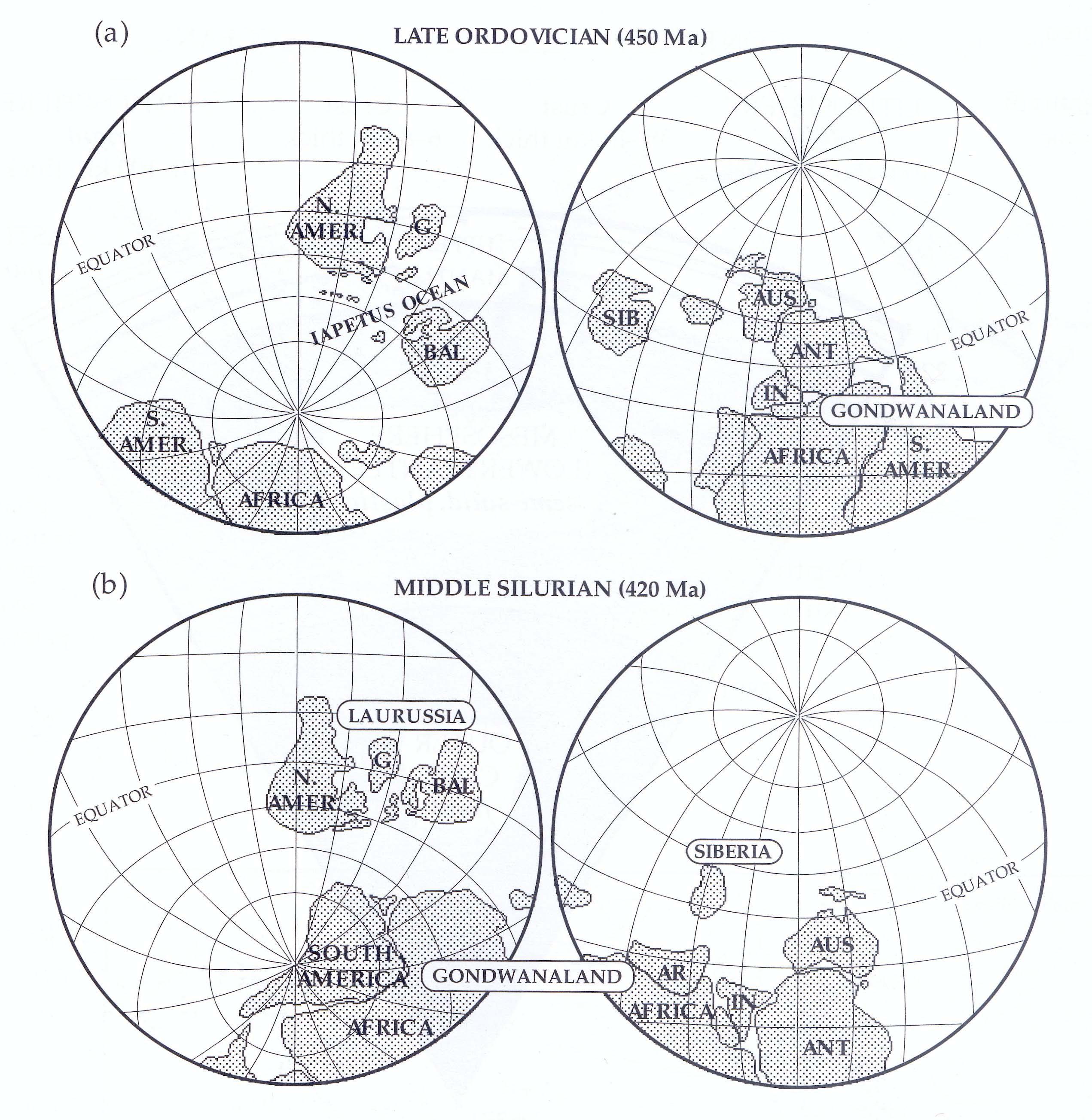
Fig. 1.8 Paleomagnetic instruction of the relative positions of (a) Laurentia (North America and Greenland), Baltica and Gondwanaland (South America, Africa, Arabia, Australia, India and Antarctica) in the Late Ordovician and (b) Laurussia (North America and Baltica) and Gondwanaland in the Middle Silurian (after Van der Voo, 1993).
Paleomagnetism developed as a geological discipline in the 1950s and 1960s. The first results indicating large-scale continental movement were greeted with some scepticism. In 1956 S. K. Runcorn demonstrated that the paleomagnetic data from Permian and Triassic rocks in North America and Great Britain agreed better if the Atlantic ocean were closed, i.e., as in the Laurasia configuration. In 1957 E. Irving showed that Mesozoic paleomagnetic data from the "southern continents" were more concordant with du Toil's Gondwanaland reconstruction than with the present arrangement of the continents. Since these pioneering studies numerous paleomagnetic investigations have established APW paths for the different continents. The quality of the paleomagnetic record is good for most geological epochs since the Devonian.
The record for older geological periods is less reliable for several reasons. In the Early Paleozoic the data become fewer and the APW paths become less well defined. In addition, the oldest parts of the paleomagnetic record are clouded by the increasing possibility of false directions due to undetected secondary magnetization. This happens when thermal or tectonic events alter the original magnetization, so that its direction no longer corresponds to that at the time of rock formation. Remagnetization can affect rocks of any age, but it is recognized more readily and constitutes a less serious problem in younger rocks.
Problems afflicting Precambrian paleomagnetism are even more serious than in the Early Paleozoic. APW paths have been derived for the Precambrian, especially for North America, but only in broad outline. In part this is because it is difficult to date Precambrian rocks precisely enough to determine the fine details of an APW path. It is often not possible to establish which is the north or south pole. In addition, the range of time encompassed by the Precambrian - more than 3.5 Ga (Billion/milliard years or thousand million years) - is about six times longer than the 570 Ma (Million years) length of the Phanerozoic, and the probability of remagnetization events is correspondingly higher.
In spite of some uncertainties, Early Paleozoic paleo-magnetism permits reassembly of the supercontinents Gondwanaland and Laurasia and traces their movements before they collided in the Carboniferous to form Pangaea. Geological and paleomagnetic evidence concur that, in the Cambrian period, Gondwanaland very likely existed as a supercontinent in essentially the du Toit configuration. It coexisted in the Early Paleozoic with three other cratonic centers: Laurentia (North America and Greenland), Baltica (northern Europe) and Siberia. Laurentia and Baltica were separated by the Iapetus ocean (Fig. 1.8a), which began to close in the Ordovician (about 450 Ma ago). Paleomagnetic data indicate that Laurentia and Baltica fused together around Late Silurian time to form the supercontinent Laurussia; at that time the Siberian block remained a separate entity. The Laurentia-Baltica collision is expressed in the Taconic and Caledonian orogenies in North America and northern Europe. The gap between Gondwanaland and Laurussia in the Middle Silurian (Fig. 1.8b) closed about the time of the Silurian-Devonian boundary (about 410 Ma ago). Readjustments of the positions of the continental blocks in the Devonian produced the Acadian orogeny. Laurussia separated from Gondwanaland in the Late Devonian, but the two supercontinents began to collide again in the Early Carboniferous (about 350 Ma ago), causing the Hercynian orogeny. By the Late Carboniferous (300 Ma ago) Pangaea was almost complete, except for Siberia, which was probably appended in the Permian.
The general configuration of Pangaea from the Late Carboniferous to the Early Jurassic is supported by paleomagnetic results from the Atlantic-bordering continents. However, the paleomagnetic data suggest that the purely geometric "Bullard-fit" is only appropriate for the later part of Pangaea's existence. The results for earlier times from the individual continents agree better for slightly different reconstructions (see Section 5.6.4.4). This suggests that some internal rearrangement of the component parts of Pangaea may have occurred. Also, the computer-assisted geometric assembly of Gondwanaland, similar to that proposed by du Toit, is not the only possible reconstruction, although paleomagnetic results confirm that it is probably the optimum one. Other models involve different relative placements of West Gondwanaland (i.e., South America and Africa) and East Gondwanaland (i.e., Antarctica, Australia and India), and imply that they may have moved relative to each other. The paleomagnetic data do not contradict the alternative models, but are not precise enough to discriminate definitively between them.
The consistency of paleomagnetic results leaves little room for doubt that the continents have changed position relative to each other throughout geological time. This lends justification to the concept of continental drift, but it does not account for the mechanism by which it has taken place. Another aspect of the paleomagnetic record - the history of magnetic field polarity rather than the APW paths - has played a key role in deducing the mechanism. The explanation requires an understanding of the Earth's internal structure, the distribution of seismicity and the importance of the ocean basins.