

Drainage Area
The Amazon Basin, the largest drainage basin in the world, covers about 40 percent of South America, an area of approximately 7 050 000 square kilometres (2 720 000 sq mi). It gathers its waters from 5 degrees north latitude to 20 degrees south latitude. Its most remote sources are found on the inter-Andean plateau, just a short distance from the Pacific Ocean.
The Amazon River and its tributaries are characterized by extensive forested areas that become flooded every rainy season. Every year the river rises more than 9 metres (30 ft), flooding the surrounding forests, known as várzea ("flooded forests"). The Amazon's flooded forests are the most extensive example of this habitat type in the world. In an average dry season, 110 000 square kilometres (42 000 sq mi) of land are water-covered, while in the wet season, the flooded area of the Amazon Basin rises to 350 000 square kilometres (140 000 sq mi).
The quantity of water released by the Amazon to the Atlantic Ocean is enormous: up to 300 000 cubic metres per second (11 000 000 cu ft/s) in the rainy season, with an average of 209 000 cubic metres per second (7 400 000 cu ft/s) from 1973 to 1990. The Amazon is responsible for about 20% of the Earth's freshwater entering the ocean. The river pushes a vast plume of freshwater into the ocean. The plume is about 400 kilometres (250 mi) long and between 100 and 200 kilometres (62 and 120 mi) wide. The freshwater, being lighter, overrides the salty ocean, diluting the salinity and altering the color of the ocean surface over an area up to 1 000 000 square miles (2 600 000 km2) large. For centuries ships have reported freshwater near the Amazon's mouth yet well out of sight of land in what otherwise seemed to be the open ocean.
The Atlantic has sufficient wave & tidal energy to carry most of the Amazon's sediments out to sea, thus the Amazon does not form a true delta. The great deltas of the world are all in relatively protected bodies of water while the Amazon empties directly into the turbulent Atlantic.
The bore is the reason the Amazon does not have a protruding delta; the ocean rapidly carries away the vast volume of silt carried by the Amazon, making it impossible for a delta to grow past the shoreline.
Exercise 7. Read the text above “Drainage Area” once again and answer the following questions:
Where does the Amazon gather its waters from?
How does the level of the river change in the rainy season?
What is the quantity of water released by the Amazon to the Atlantic Ocean?
What is the size of the plume in the Atlantic Ocean?
Why doesn’t the Amazon form a true delta?
Why isn’t silt deposited in delta past the shoreline?
Exercise 8. Read the following text “Origins” and fill in the gaps with the words given below:
Origins
T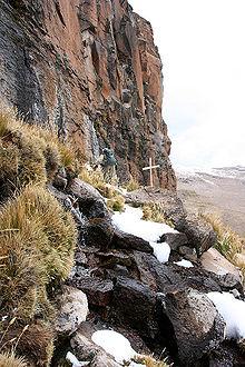 he
Amazon originates from the Apacheta cliff in Arequipa at theNevado
Mismi,
with a sole sign of a wooden cross.
he
Amazon originates from the Apacheta cliff in Arequipa at theNevado
Mismi,
with a sole sign of a wooden cross.
The Amazon river has a series of major river 1 … in Colombia, Peru and Ecuador, some of which flow into the Marañón and Ucayali, others directly into the Amazon proper. Among others, these include the 2 … rivers: Putumayo, Caquetá, Vaupés, Guainía, Morona, Pastaza, Nucuray, Urituyacu, Chambira, Tigre, Nanay, Napo, and Huallaga.
The most distant source of the Amazon was established in 1996, 2001, 2007, and 2008, as a glacial stream on a 3 … 5 597 m (18 363 ft) peak called Nevado Mismi in the Peruvian Andes, roughly 160 km (99 mi) west of Lake Titicaca and 700 km (430 mi) southeast of Lima. The 4 … from Nevado Mismi flow into the Quebradas Carhuasanta and Apacheta, which flow into the Río Apurímac which is a 5 … of the Ucayali which later joins the Marañón to form the Amazon proper. While the Ucayali – Marañón confluence is the point at which most geographers place the beginning of the Amazon proper, in Brazil the river is known at this point as the Solimões das Águas. Shortly downriver from that 6 … the darkly colored waters of the Rio Negro meet the sandy colored Rio Solimões, and for over 6 km (4 mi) these waters run 7 … by side without mixing.
After the confluence of Río Apurímac and Ucayali, the river leaves Andean terrain and is instead surrounded by 8 … . From this point to`the Marañón, some 1 600 km (990 mi), the forested banks are just out of water, and are inundated long 9 … the river attains its maximum flood stage. The low river banks are interrupted by only a few 10 …, and the river enters the enormous Amazon Rainforest.
The river systems and flood plains in Brazil, Peru, 11 …, Colombia and Venezuela, whose waters drain into the Solimões and its tributaries are called the "Upper Amazon". The Amazon River proper runs mostly through Brazil and Peru, it is part of the 12 … between Colombia and Perú, and it has tributaries reaching into Venezuela, Colombia, Ecuador, and Bolivia.
Words:
– floodplain
– before
– tributary
– hills
– border
– snowcapped
– confluence
– following
– Ecuador
– systems
– side
– waters
Exercise 9. Look through the text above once again and answer the questions given below:
The Amazon River has a series of major river systems, hasn’t it?
Where is the most distant source of the Amazon?
Where do most geographers place the beginning of the Amazon proper?
The place where the river enters the rainforest is mountainous, isn’t it?
The waters of the Rio Negro are sandy colored, aren’t they?
Exercise 10. Read the following text “Flooding” and write 6 “yes or no” questions to it, then read your questions for other students to answer: