

RADIO AIDS
.pdf104 |
RADIO AIDS |
4 SEP 09 |
SECTION 5. SURVEILLANCE SYSTEMS
FIG 4-5-7
ADS-B, TIS-B, AND FIS-B
Broadcast Services Architecture
b.ADS-B Certification and Performance Requirements
ADS-B equipment may be certified as an air-to- air system for enhancing situational awareness and as a surveillance source for air traffic services. Refer to the aircraft’s flight manual supplement for the specific aircraft installation.
c.ADS-B Capabilities
1.ADS-B enables improved surveillance services, both air-to-air and air-to-ground, especially in areas where radar is ineffective due to terrain or where it is impractical or cost prohibitive. Initial NAS applications of air-to-air ADS-B are for “advisory,” use only, enhancing a pilot’s visual acquisition of other nearby equipped aircraft either when airborne or on the airport surface. Additionally, ADS-B will enable ATC and fleet operators to monitor aircraft throughout the available ground station coverage area. Other applications of ADS-B may include enhanced search and rescue operations and advanced air-to-air applications such as spacing, sequencing, and merging.
2.ADS-B avionics typically allow pilots to enter the aircraft’s call sign and Air Traffic Control (ATC)-assigned transponder code, which will be transmitted to other aircraft and ground receivers. Pilots are cautioned to use care when selecting and entering
the aircraft’s identification and transponder code. Some ADS-B avionics panels are not interconnected to the transponder. Therefore, it is extremely important to ensure that the transponder code is identical in the ADS-B and transponder panel. Additionally, UAT systems provide a VFR “privacy” mode switch position that may be used by pilots when not wanting to receive air traffic services. This feature will broadcast a “VFR” ID to other aircraft and ground receivers, similar to the “1200” transponder code.
3.ADS-B is intended to be used in-flight and on the airport surface. ADS-B systems should be turned “on” – and remain “on”
– whenever operating in the air and on the airport surface, thus reducing the likelihood of runway incursions. Civil and military Mode A/C transponders and ADS-B systems should be adjusted to the “on” or normal operating position as soon as
practical, unless the change to “standby” has been accomplished previously at the request of ATC. Mode S transponders should be left on whenever power is applied to the aircraft.
d.ATC Surveillance Services using ADS-B —Procedures and Recommended Phraseology — For Use In Alaska Only
© JEPPESEN, 2006, 2009. ALL RIGHTS RESERVED.

19 MAR 10 |
RADIO AIDS |
105 |
SECTION 5. SURVEILLANCE SYSTEMS
Radar procedures, with the exceptions found in this paragraph, are identical to those procedures prescribed for radar in AIM Chapter 4 and Chapter 5.
1.Preflight:
If a request for ATC services is predicated on ADS-B and such services are anticipated when either a VFR or IFR flight plan is filed, the aircraft’s “N” number or call-sign as filed in “Block 2” of the Flight Plan shall be entered in the ADS-B avionics as the aircraft’s flight ID.
2.Inflight:
When requesting ADS-B services while airborne, pilots should ensure that their ADS-B equipment is transmitting their aircraft’s “N” number or call sign prior to contacting ATC. To accomplish this, the pilot must select the ADS-B “broadcast flight ID” function.
NOTE: The broadcast “VFR” or Standby” mode built into some ADS-B systems will not provide ATC with the appropriate aircraft identification information. This function should first be disabled before contacting ATC.
3.Aircraft with an Inoperative/Malfunctioning ADS-B Transmitter or in the Event of an Inoperative Ground Broadcast Transceiver (GBT).
(a)ATC will inform the flight crew when the aircraft’s ADS-B transmitter appears to be inoperative or malfunctioning:
PHRASEOLOGY:
YOUR ADS-B TRANSMITTER APPEARS TO BE INOPERATIVE/MALFUNCTIONING. STOP ADS-B TRANSMISSIONS.
(b)ATC will inform the flight crew when the GBT transceiver becomes inoperative or malfunctioning, as follows:
PHRASEOLOGY:
(Name of facility) GROUND BASED TRANSCEIVER INOPERATIVE/MALFUNCTIONING. (And if appropriate) RADAR CONTACT LOST.
NOTE: An inoperative or malfunctioning GBT may also cause a loss of ATC surveillance services.
(c)ATC will inform the flight crew if it becomes necessary to turn off the aircraft’s ADS-B transmitter.
PHRASEOLOGY:
STOP ADS-B TRANSMISSIONS.
(d)Other malfunctions and considerations:
Loss of automatic altitude reporting capabilities (encoder failure) will result in loss of ATC altitude advisory services.
e.ADS-B Limitations
1.The ADS-B cockpit display of traffic is NOT intended to be used as a collision avoidance system and does not relieve the pilot’s responsibility to “see and avoid” other aircraft. (See paragraph 5-5-8, See and Avoid). ADS-B shall not be used for avoidance maneuvers during IMC or other times when there is no visual contact with the intruder aircraft. ADS-B is intended only to assist in visual acquisition of other aircraft. No avoidance maneuvers are provided nor authorized, as a direct result of an ADS-B target being displayed in the cockpit.
2.Use of ADS-B radar services is limited to the service volume of the GBT.
NOTE: The coverage volume of GBTs are limited to line-of-sight.
f.Reports of ADS-B Malfunctions
Users of ADS-B can provide valuable assistance in the correction of malfunctions by reporting instances of undesirable system performance. Reporters should identify the time of observation, location, type and identity of aircraft, and describe the condition observed; the type of avionics system and its software version in use should also be included. Since ADS-B performance is monitored by maintenance personnel rather than ATC, it is suggested that malfunctions be reported in any one of the following ways:
1.By radio or telephone to the nearest Flight Service Station (FSS) facility.
2.By FAA Form 8740-5, Safety Improvement Report, a postage-paid card is designed for this purpose. These cards may be obtained from FAA FSSs, Flight Standards District Offices, and general aviation fixed-based operators.
3.By reporting the failure directly to the FAA Safe Flight 21 program at 1-877-FLYADSB or http://www.adsb.gov.
© JEPPESEN, 2006, 2010. ALL RIGHTS RESERVED.

106 |
RADIO AIDS |
19 MAR 10 |
SECTION 5. SURVEILLANCE SYSTEMS
4-5-8 TRAFFIC INFORMATION SERVICE-BROADCAST (TIS-B)
TIS-B is the broadcast of ATC derived traffic information to ADS-B equipped (1090ES or UAT) aircraft from ADS-B ground stations. The source of this traffic information is derived from ground-based air traffic surveillance sensors, typically fromradar targets. TIS-Bservice will be available throughout the NAS where there are both adequate surveillance coverage (radar) from ground sensors and adequate broadcast coverage from ADS-B ground stations. The quality level of traffic information provided by TIS-B is dependent upon the number and type of ground sensors available as TIS-B sources and the timeliness of the reported data.
a.TIS-B Requirements.
In order to receive TIS-B service, the following conditions must exist:
1.Aircraft must be equipped with an ADS-B transmitter/receiver or transceiver, and a cockpit display of traffic information (CDTI).
2.Aircraft must fly within the coverage volume of a compatible ground-based transceiver (GBT) station that is configured for TIS-B uplinks. (Not all GBTs provide TIS-B due to a lack of radar coverage or because a radar feed is not available.)
3.Aircraft must be within the coverage of and detected by at least one ATC radar serving the GBT in use.
b.TIS-B Capabilities.
1.TIS-B is intended to provide ADS-B equipped aircraft with a more complete traffic picture in situations where not all nearby aircraft are equipped with ADS-B. This advisory-only application will enhance a pilot’s visual acquisition ofother traffic.
2.Only transponder-equipped targets (i.e.,Mode A/C or Mode S transponders)
are detected and transmitted through the ATC ground system architecture. Current radar siting may result in limited radar surveillance coverage at lower altitudesnear some airports, with subsequently limited TIS-B Service volume coverage. If there is noradar coverage in a given area, then there will be no TIS-B coverage in that area.
c.TIS-B Limitations.
1.TIS-B is NOT intended to be used as a collision avoidance system and does not relieve the pilot’s responsibility to “see and avoid” other aircraft, in accordance with 14CFR §91.113b. TIS-B must notbe used for avoidance maneuvers during times when there is no visual contact with the intruder aircraft. TIS-B is intended only to assist in the visual acquisition of other aircraft.
NOTE: No aircraft avoidance maneuvers are authorized as a directresult of a TIS-B target being displayed in the cockpit.
2.While TIS-B is a useful aid to visual traffic avoidance, its inherent system limitations must be understood to ensure proper use.
(a)A pilot may receive an intermittent TIS-B target of themselves, typically when maneuvering (e.g., climbing turns) due to the radar not tracking the aircraft as quickly as ADS-B.
(b)The ADS-B-to-radar association process within the ground system may at times have difficulty correlating an ADS-B report with corresponding radar returns from the same aircraft. When this happens the pilot will see duplicate traffic symbols (i.e., “TIS-B shadows”) on the cockpit display.
(c)Updates of TIS-B traffic reports will occur less often than ADS-B traffic updates. TIS-B position updates will occur approximately once every 3-13 seconds depending on the radar coverage. In comparison, the update rate for ADS-B is nominally once per second.
(d)The TIS-B system only detects and uplinks data pertaining to transponder equipped aircraft. Aircraft without a transponder will not be displayed as a TIS-B target.
(e)There is no indication provided when any aircraft is operating inside or outside the TIS-B service volume, therefore it is difficult to know if one is receiving uplinked TIS-B traffic information.
3.Pilots and operators are reminded that the airborne equipment that displays TIS-B targets is for pilot situational awareness only and is not approved as a collision avoidance tool. Unless there is an imminent emergency requiring immediate action, any deviation from an air traffic control clearance in response to perceived converging traffic appearing on a TIS-B display must be approved by the controlling ATC facility before commencing the maneuver, except as permitted under certain conditions in 14CFR §91.123. Uncoordinated deviations may place an aircraft in close proximity to other aircraft under ATC control not seen on the airborne equipment and may result in a pilot deviation or other incident.
d.Reports of TIS-B Malfunctions
© JEPPESEN, 2006, 2010. ALL RIGHTS RESERVED.

19 MAR 10 |
RADIO AIDS |
107 |
SECTION 5. SURVEILLANCE SYSTEMS
Users of TIS-B can provide valuable assistance in the correction of malfunctions by reporting instances of undesirable system performance. Reporters should identify the time of observation, location, type and identity of the aircraft, and describe the condition observed; the type of avionics system and its software version used. Since TIS-B performance is monitored by maintenance personnel rather than ATC, it is suggested that malfunctions be reported in anyone of the following ways:
1.By radio or telephone to the nearest Flight Service Station (FSS) facility.
2.By FAA Form 8740-5, Safety Improvement Report, a postage-paid card is designed for this purpose. These cards may be obtained from FAA FSSs, Flight Standards District Offices, and general aviation fixed-based operators.
3.By reporting the failure directly to the FAA Safe Flight 21 program at 1-877-FLYADSB or http://www.adsb.gov.
4-5-9 Flight Information
Service-Broadcast (FIS-B)
a.FIS-B is a ground broadcast service provided through the ADS-B Services network over the UAT data link that operates on 978 MHz. The FAA FIS-B system provides pilots and flight crews of properly equipped aircraft with a cockpit display of certain aviation weather and aeronautical information. FIS-B service availability is expected across the NAS in 2013 and is currently available within certain regions.
b.The weather products provided by FIS-B are for information only. Therefore, these products do notmeet the safety and regulatory requirements of official weather products. The weather products displayed on FIS-B should not be used as primary weather products, i.e., aviation weather to meet operational and safety requirements. Official weatherproducts (primary products) can be obtained from a variety of sources including ATC, AFSSs, and, if applicable, AOCC VHF/HF voice, which can transmit aviation weather, NOTAMS, and other operational aeronautical information to aircraft in flight. FIS-B augments the traditional ATC/FSS/AOCC services by providing additional information and, for some products, offers the advantage of being displayed graphically. By using FIS-B for orientation and information, the usefulness of information received from official sources may be enhanced, but the user should be alert and understand any limitations associated with individual products. FIS-B provides the initial basic products listed below at no-charge to the user. Additional products are envisioned, but may incur subscription charges to the user. FIS-B reception is line-of-sight within the service volume of the ground infrastructure.
1.Airmen’s Meteorological Conditions (AIRMET) – Text/graphical report – A concise description of expected occurrence of specified enroute weather phenomena.
REFERENCE – Advisory Circular AC-00- 45, “Aviation Weather Services.”
2.Convective Significant Meteorological Conditions (SIGMET) – Text report/graphical – Convective SIGMETs (also known internationally as SIGMET for Convection) are issued for the contiguous U.S. Each bulletin includes one or more Convective SIGMETs for a specific region of the CONUS. Convective SIGMETs issued for thunderstorms and related phenomena do not include references to all weather associated with thunderstorms such as turbulence, icing, low-level wind shear and IFR conditions.
REFERENCE – Advisory Circular AC-00- 45, “Aviation Weather Services.”
3.Aviation Routine Weather Reports (METAR) – Text reports – Surface meteorological data. The body of the report includes airport identifier, time of observation, wind, visibility, runway visual range, present weather phenomena, sky conditions, temperature, dew point, and altimeter setting. Remarks may be appended to the end.
REFERENCE – Advisory Circular AC-00- 45, “Aviation Weather Services.”
4.Special Aviation Reports (SPECI) – Text reports – Non-routine, unscheduled report when any of SPECI criteria have been met. Contains all data elements found in METAR plus additional information which elaborates on data.
REFERENCE – Reference Advisory Circular AC-00-45, “Aviation Weather Services.”
5.Next Generation Radar (NEXRAD)
(CONUS and Regional) – Derived from Next Generation Weather Radar (WSR-88D). Radar mosaic consists of multiple single site radar images combined to produce a graphical image on a regional or national scale. Regional and national radar mosaicscan be found at the National Weather Service (NWS) Doppler Radar Images web site: http://radar.weather.gov/ridge/.
REFERENCE – Advisory Circular AC-00- 45, “Aviation Weather Services.”
6.Notice to Airmen (NOTAM) Distant and Flight Data Center (D/FDC) – Text/graphical reports – includes Temporary Flight Restrictions (TFRs) – TFR text and graphic reports, prescribes procedures used to obtain, format, and disseminate information on unanticipated or temporary changes to components of or hazards in
© JEPPESEN, 2006, 2010. ALL RIGHTS RESERVED.

108 |
RADIO AIDS |
19 MAR 10 |
SECTION 5. SURVEILLANCE SYSTEMS
the NAS until the associated aeronautical charts and related publications have been amended.
REFERENCE – FAA Order JO 7930.2, Notices to Airmen (NOTAM).
7.Pilot Weather Reports (PIREP) – Text report – Pilots report observations to assist other pilots with flight planning and preparation, help NWS verify forecast products, and create more accurate products for aviation community.
REFERENCE – Advisory Circular AC-00- 45, “Aviation Weather Services.”
8.Significant Meteorological Information (SIGMET) – Text/graphical report – Potentially hazardous en route phenomena such as thunderstorms and hail, turbulence, icing, sand and dust storms, tropical cyclones, and volcanic ash in an area affecting 3,000 square miles or an area deemed to have a significant effect on safety of aircraft operations.
REFERENCE – Advisory Circular AC-00- 45, “Aviation Weather Services.”
9.Special Use Airspace (SUA) Status – Text/graphical report – Establishes/designates airspace in the interest of National Defense, security and/or welfare. Charted SUA identifies to other airspace users where these activities occur. SUA is airspace of defined dimensions wherein activities must be confined because of their nature, or wherein limitations may be imposed upon aircraft operations that are not a part of those activities.
REFERENCE – FAA Order JO 7400.2G, Procedures for Handling Airspace Matters.
10.Terminal Aerodrome Forecast (TAF) and their amendments (AMEND) – Text report
– Routine forecast that gives a concise statement of expected meteorological conditions for a specified time period within five statute miles (SM) of the center of the airport’s runway complex (terminal). TAFs are amended whenever they become, in the forecaster’s judgment, unrepresentative of existing or expected conditions, particularly regarding those elements and events significant to aircraft and airports. An amended forecast is identified by TAF AMD (in place of TAF) on the first line of the forecast text.
REFERENCE – Advisory Circular AC-00-
45, “Aviation Weather Services.”
11.Temperature Aloft - Text report - Computer prepared forecasts, based on North American Mesoscale (NAM) forecast model run, of temperature at specified times, altitudes, and locations.
REFERENCE – Advisory Circular AC-00- 45, “Aviation Weather Services.”
12.Winds Aloft – Text report – Computer prepared forecasts, based on North American Mesoscale (NAM) forecast model run, of wind direction and wind speed at specified times, altitudes, and locations.
REFERENCE – Advisory Circular AC-00- 45, “Aviation Weather Services.”
FIS-B Basic Product Update and Transmission Intervals
1The Update Interval is the rate at which the product data is available from the source.
2The Transmission Interval is the amount of time within which a new or updated product transmission must be completed and the rate or repetition interval at which the product is rebroadcast.
NOTE: Details concerning the content, format, and symbols of the various data link products provided should be obtained from the specific avionics manufacturer.
© JEPPESEN, 2006, 2010. ALL RIGHTS RESERVED.

24 FEB 06 |
RADIO AIDS |
111 |
DIRECTION FINDING PROCEDURES
InformationDIRECTION FINDING PROCEDURES about Direction Finding Procedures published in this section is extracted from ICAO Annex 10. It is provided for reference use only. The information is generally applicable around the world. Regional variations may exist.
ICAO AERONAUTICAL TELECOMMUNICATION STANDARDS
— ANNEX 10
6.2DIRECTION FINDING INTRODUCTORY NOTES
1.Direction-finding stations work either singly or in groups of two or more stations under the direction of a main direction-finding station.
2.A direction-finding station working alone can only determine the direction of an aircraft in relation to itself.
6.2.1 Recommendation — A direction-finding station working alone should give the following, as requested:
1.true bearing of the aircraft, using the appropriate phrase;
2.true heading to be steered by the aircraft, with no wind, to head for the direction-finding station using the appropriate phrase;
3.magnetic bearing of the aircraft, using the appropriate phrase;
4.magnetic heading to be steered by the aircraft, with no wind, to make for the station using appropriate phrase.
6.2.2 Recommendation — When direc- tion-finding stations work as a network to determine the position of an aircraft, the bearing taken by each station should be sent immediately to the station controlling the direction-finding network to enable the position of the aircraft to be determined.
6.2.2.1 Recommendation — The station controlling the network should, on request, give the aircraft its position in one of the following ways:
1.position in relation to a point of reference or in latitude and longitude, using the appropriate phrase;
2.true bearing of the aircraft in relation to the direc- tion-finding station or other specified point using the appropriate phrase, and its distance from the direction-finding station or point, using the appropriate phrase;
3.magnetic heading to steer with no wind, to make for the direction-finding station or other specified point using the appropriate phrase, and its distance from the direction-finding station or point, using the appropriate phrase.
of service that is desired by the use of the appropriate phrase.
6.2.5 In radiotelephony, an aircraft station which requests a bearing shall end the transmission by repeating its call sign. If the transmission has been too short for the direction-finding station to obtain a bearing, the aircraft shall give a longer transmission for two periods of the approximately ten seconds, or alternatively provide such other signals as may be requested by the direction-finding station.
6.2.5.1 In radiotelephony, an aircraft station which requests a bearing shall end the transmission by repeating its call sign. If the transmission has been too short for the direction-finding station to obtain a bearing, the aircraft shall give a longer transmission for two periods of the approximately ten seconds, or alternatively provide such other signals as may be requested by the direction-finding station.
NOTE: Certain types of VHF/DF stations require the provision of a modulated signal (voice transmission) in order to take a bearing.
6.2.6When a direction-finding station is not satisfied with its observation, it shall request the aircraft station to repeat the transmission.
6.2.7When a heading or bearing has been requested, the direction-finding station shall advise the aircraft station in the following form:
1.the appropriate phrase;
2.bearing or heading in degrees in relation to the direction-finding station, sent as three figures;
3.class of bearing;
4.time of observation, if necessary.
6.2.8 When a position has been requested, the direction-finding control station, after plotting all simultaneous observations, shall determine the observed position of the aircraft and shall advise the aircraft station in the following form:
1.the appropriate phrase;
2.the position;
3.class of position;
4.time of observation.
6.2.9As soon as the aircraft station has received the bearing, heading or position it shall repeat back the message for confirmation, or correction.
6.2.10When positions are given by bearing or
6.2.3Aircraft stations shall normally make reheading and distance from a known point other than
quest for bearings, courses or positions, to the aeronautical station responsible, or to the station controlling the direction-finding network.
6.2.4 To request a bearing, heading or position, the aircraft station shall call the aeronautical station or the direction-finding control station on the listening frequency. The aircraft shall then specify the type
the station making the report, the reference point shall an aerodrome, prominent town or geographic feature. An aerodrome shall be given in preference to other places. When a large city or town is used as a reference place, the bearing or heading, and the distance given shall be measured from its center.
© JEPPESEN SANDERSON, INC. 2006. ALL RIGHTS RESERVED.

112 |
RADIO AIDS |
24 FEB 06 |
DIRECTION FINDING PROCEDURES
6.2.11When the position is expressed in latitude and longitude, groups of figures for degrees and minutes shall be used followed by the letter N or S for latitude and the letter E or W for longitude, respectively. In radiotelephony the words NORTH, SOUTH, EAST or WEST shall be used.
6.2.12According to the estimate by the direc- tion-finding station of the accuracy of the observation, bearings and positions shall be classified as follows:
Bearings
Class “A” — Accurate within plus or minus 2 degrees;
Class “B” — Accurate within plus or minus 5 degrees;
Class “C” — Accurate within plus or minus 10 degrees;
Class “D” — Accuracy less than Class C.
Positions
Class “A” — Accurate within 9.3 km (5 NM);
Class “B” — Accurate within 37 km (20 NM);
Class “C” — Accurate within 92 km (50 NM);
Class “D” — Accuracy less than Class C.
6.2.13 Direction-finding stations shall have authority to refuse to give bearings, headings or positions when conditions are unsatisfactory or when bearings do not fall within the calibrated limits of the station, stating the reason at the time of refusal.
© JEPPESEN SANDERSON, INC. 2006. ALL RIGHTS RESERVED.

20 MAR 09 |
RADIO AIDS |
121 |
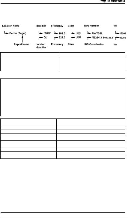
NAVIGATION AIDS LEGEND
LEGEND
The listings are in alphabetical sequence by country.
The following information is provided:
1The letter “N” indicates that the VOR and TACAN or DME facility are separated by at least 6 seconds (one tenth of a minute) of either longitude or latitude. The TACAN (T) or DME (D) facility class code is included with the VOR listing and the INS coordinates shown are for the VOR facility. On the line immediately below this listing the TACAN or DME facility information is listed with the TACAN or DME coordinates. To further highlight the difference in coordinates TACAN or DME identifier is offset below the VOR identifier.
INS Coordinates |
In avionics keyboarding format, latitude and longitude in degrees, minutes and tenths of |
|
minutes. |
VAR/Stn Decl |
Magnetic variation/station declination. |
Elev. |
Station elevation, shown only for those navaids with DME capability and if this |
|
information is officially published by State authority. |
ILS COMPONENTS
An ILS listing is provided at the end of each country listing. It is in alphabetical sequency by location name, and includes both localizer and outer marker/ locator information.
© JEPPESEN, 1982, 2009. ALL RIGHTS RESERVED.
122 |
RADIO AIDS |
20 MAR 09 |
NAVIGATION AIDS LEGEND
LOCALIZER AND OUTER MARKER/
LOCATOR
PHONETIC ALPHABET AND MORSE CODE
© JEPPESEN, 1982, 2009. ALL RIGHTS RESERVED.

10 JUL 09 |
RADIO AIDS |
E-31 |
NAVIGATION AIDS LISTED BY IDENTIFIER - Europe
(See end of listing for Localizers)
A
ASodankyla, Finland
AAlmaza AB (Almaza), Egypt
AGallivare, Sweden
AAL |
Aalborg, Denmark |
AAR |
Aarhus, Denmark |
AB |
Albi, France |
AB |
Hagfors, Sweden |
ABA |
Schiphol (Amsterdam), Netherlands |
ABB |
Abbeville, France |
ABD |
Abyad (Damascus), Syria |
ABN |
Albenga, Italy |
ABT |
Albacete, Spain |
ABU |
Abu Argub, Libya, SPAJ |
ABU |
Altenburg, Germany |
ABY |
Albert Bray, France |
ABY |
Bray (Albert), France |
AC |
Hultsfred, Sweden |
AC |
Napoleon Bonaparte (Ajaccio), France |
ACD |
Alcobendas, Spain |
AD |
Anda (Sandane), Norway |
AD |
Anda (Sandane), Norway |
ADA |
Adana, Turkey |
ADC |
Le Castellet, France |
ADM |
Al-Massira (Agadir), Morocco |
ADN |
Aberdeen, United Kingdom |
ADQ |
Ciudad Real, Spain |
ADR |
Adrar, Algeria |
ADV |
Advent (Svalbard), Norway |
ADX |
Andraitx, Spain |
AE |
Aalborg, Denmark |
AEA |
Alghero, Italy |
AFI |
Affligem, Belgium |
AG |
Agen, France |
AG |
Houari Boumediene (Algiers), Algeria |
AG |
La Garenne (Agen), France |
AGB |
Augsburg, Germany |
AGD |
Altenburg, Germany |
AGN |
Agen, France |
AGO |
Angouleme, France |
AH |
Angelholm AB, Sweden |
AH |
Fertilia (Alghero), Italy |
AHO |
Alghero, Italy |
AI |
Alicante, Spain |
AIB |
Airbus Trng, France |
AIL |
Aswan Intl (Aswan), Egypt |
AJO |
Ajaccio, France |
AKC |
Akcakale, Turkey |
AKI |
Akhisar, Turkey |
AKU |
Akujarvi (Ivalo), Finland |
AL |
Lepsoy (Alesund), Norway |
AL |
Matacan (Salamanca), Spain |
ALA |
Alta, Norway |
ALB |
Albenga, Italy |
ALB |
Alboran, Spain |
ALD |
Memmingen (Memmingen/Allgau), Germany |
ALE |
Aleppo, Syria |
ALF |
Alster, Germany |
ALG |
Alghero, Italy |
ALG |
Memmingen (Memmingen/Allgau), Germany |
ALI |
Cairo, Egypt |
ALM |
Aix-Les-Milles, France |
ALM |
Al Hoceima, Morocco |
ALM |
Alma, Sweden |
ALR |
Dar El Beida, Algeria |
ALS |
Al-Massira (Agadir), Morocco |
ALS |
Alsie, Denmark |
ALT |
Alicante, Spain |
ALU |
Al Hoceima, Morocco |
AM |
Almeria, Spain |
AM |
Brie-Champniers (Angouleme), France |
AMB |
Amboise, France |
AME |
Amendola, Italy |
AMI |
Amiko (Dakovica), Serbia-Montenegro |
AML |
Al-Massira (Agadir), Morocco |
AMN |
Almeria, Spain |
AMN |
Amman, Jordan |
AMR |
Almeria, Spain |
AMS |
Amsterdam, Netherlands |
AMU |
Amberieu, France |
AN |
Arvidsjaur, Sweden |
AN |
Caumont (Avignon), France |
AN |
Esenboga (Ankara), Turkey |
AN |
Rabah Bitat (Annaba), Algeria |
ANB |
Annaba, Algeria |
ANC |
Ancona, Italy |
AND |
Andoya, Norway |
ANE |
Arlanda (Stockholm), Sweden |
ANG |
Angers, France |
ANK |
Ankara, Turkey |
ANM |
Meythet (Annecy), France |
ANS |
Ansbach, Germany |
ANT |
Antalya, Turkey |
ANT |
Antoni, Finland |
ANT |
Antwerp (Deurne), Belgium |
ANW |
Arlanda (Stockholm), Sweden |
AOG |
Rota, Spain |
AP |
Aberporth, United Kingdom |
AQ |
Aberdeen, United Kingdom |
AQ |
Aqaba, Jordan |
AQA |
Aqaba, Jordan |
AQB |
Aqaba, Jordan |
AQC |
Aqaba, Jordan |
AR |
Aurillac, France |
ARB |
Arbatax, Italy |
ARE |
Monts D’Arree, France |
ARF |
Arifiye (Topel), Turkey |
ARH |
El Arish, Egypt |
ARI |
Agri, Turkey |
ARI |
Nador, Morocco |
ARL |
Arlanda (Stockholm), Sweden |
ARN |
Arbancon, Spain |
ARS |
Aros, Sweden |
ARV |
Arvidsjaur, Sweden |
ARW |
Nador, Morocco |
AS |
Alfa-Sierra (Kemi), Finland |
AS |
Angers, France |
AS |
Arvidsjaur, Sweden |
AS |
Marce (Angers), France |
ASE |
Arlanda (Stockholm), Sweden |
ASK |
Askoy (Bergen), Norway |
ASN |
Aswan, Egypt |
AST |
Asturias, Spain |
AST |
Asyut, Egypt |
ASW |
Arlanda (Stockholm), Sweden |
AT |
Annecy, France |
ATA |
Alta, Norway |
ATE |
Alicante, Spain |
ATF |
Aberdeen, United Kingdom |
ATN |
Autun, France |
ATR |
Alcantarilla (Murcia), Spain |
AUB |
Aubenas, France |
AUG |
Augsburg, Germany |
AV |
Asturias, Spain |
AV |
Avord, France |
AV |
Save (Goteborg), Sweden |
AVD |
Avord, France |
AVI |
Aviano, Italy |
AVN |
Avignon, France |
AVS |
Asturias, Spain |
AX |
Auxerre, France |
AX |
Branches (Auxerre), France |
AXD |
Alexandria, Egypt |
AYT |
Antalya, Turkey |
AZR |
Inezgane (Agadir), Morocco |
B
BBravo (Kittila), Finland
BKuopio, Finland
BPori, Finland
BManises (Valencia), Spain
BA |
Banak (Lakselv), Norway |
BA |
Ben Gurion (Tel Aviv), Israel |
BAG |
Baglum (Ankara), Turkey |
BAI |
Bailen, Spain |
BAK |
Backa, Sweden |
BAL |
Baldonnel, Ireland |
BAM |
Barmen, Germany |
BAN |
Banias, Syria |
BAN |
Barahona, Spain |
BAN |
Sidi Ben Aoun, Tunisia |
© JEPPESEN, 1993, 2009. ALL RIGHTS RESERVED.