

ppl_03_e2
.pdfID: 3658
Customer: Oleg Ostapenko E-mail: ostapenko2002@yahoo.com
Customer: Oleg Ostapenko E-mail: ostapenko2002@yahoo.com
CHAPTER 12: FLIGHT PLANNING
INTRODUCTION.
What is Flight Planning?
Whenever you fly, you must flight plan. Even a short local area flight requires the pilot to obtain a reliable weather forecast and to observe the actual weather situation in the vicinity of the airfield to see if it is suitable for the intended flight. Furthermore, the pilot must also make sure that the aircraft is serviceable and carries sufficient fuel and oil. Additionally, the pilot should set an aim for the flight, and must always carry a suitable up-to-date aeronautical chart of the area in which the flight is to take place. All these activities constitute what is termed flight planning.
However, the expression flight planning normally refers to the activities associated with planning for a cross-country navigational flight, which is to be conducted either visually or on instruments. In this chapter we will assume that you are planning to carry out a visual navigational flight.
Good flight planning for a cross country flight will help ensure that the flight proceeds efficiently and in safety. As you will have learnt from earlier chapters, sound navigational preparation will make navigation, once airborne, as undemanding as possible, leaving the pilot with maximum mental and physical capacity to fly the aircraft, deal with radiotelephony requirements, and cope with any revisions of his flight plan that prove necessary. Successful flight planning will normally consist of the following activities:
•Planning the route.
•Checking Airspace Restrictions
•Obtaining a weather forecast.
•Chart preparation.
•Completing the flight log.
•Fuel calculations.
•Weight and balance calculations.
•Aeroplane performance calculations.
•Submitting a flight plan.
Personal Equipment.
Before starting your flight planning, you should make sure that you have the appropriate items of personal equipment. The following list is a guide.
•Relevant charts covering your intended route.
•Navigation computer, ruler and protractor.
•A reliable watch or stopwatch.
•A Torch.
•Pencils and pens.
•Clipboard or kneepad for the flight log.
•Sunglasses.
•Aircraft checklists.
•Headsets for yourself and passengers.
207

Order: 6026
Customer: Oleg Ostapenko E-mail: ostapenko2002@yahoo.com
Customer: Oleg Ostapenko E-mail: ostapenko2002@yahoo.com
CHAPTER 12: FLIGHT PLANNING
PLANNING THE ROUTE.
The starting point for flight planning is invariably your choosing a destination to which you wish to fly. In this chapter, we will assume that you wish to fly from Oxford Kidlington to Hawarden, an aerodrome situated about 10 miles South of Liverpool. (See Figure 12.1.) You should have your own 1:500 000 chart of Southern England at hand while working through this chapter. By referring to your own chart regularly, you will draw maximum benefit from your study of the chapter.
Figure 12.1 Alternative routes from Oxford to Hawarden. The route via Ludlow will keep you clear of controlled airspace
Having chosen your destination, there are several factors which may influence your choice of route to that destination.
208

ID: 3658
Customer: Oleg Ostapenko E-mail: ostapenko2002@yahoo.com
Customer: Oleg Ostapenko E-mail: ostapenko2002@yahoo.com
CHAPTER 12: FLIGHT PLANNING
The Weather.
A primary factor influencing your choice of route will be the weather. If your intention were simply to plan a cross country route for training purposes only, you would probably plan to go where the weather is most favourable. On the other hand, if you wish to fly to a particular destination, in this case, to Hawarden, then you will have to accept the weather as it is, or decide that the weather is not good enough for the flight to take place. You may also be able to pick a route which will keep your aircraft in acceptable weather conditions. Whatever the case may be, you must not take-off on any flight without obtaining a weather forecast.
Routing Considerations.
In order to fly from A to B as quickly as possible, the direct straight line route will be the fastest route but not always the best route. For example, the direct route to Hawarden from Oxford would take you under the Birmingham Control Area (CTA). There would be nothing illegal about this, but if you strayed slightly right of track you would be under a part of the CTA with a lower limit of 2 500 feet. Consequently, while in the vicinity of the Birmingham CTA, it would be unwise to plan on flying higher than an altitude of 2 000 feet. This altitude is rather low for flight over a major conurbation and, furthermore, you would be unable to climb if you needed to.
The direct route from Oxford to Hawarden would also take you through the Combined Military Air Traffic Zones (CMATZ) at Ternhill and Shawbury. There is no reason why you should not fly through the CMATZ; it would be good practice at using a MATZ Penetration Service, but, if you were to be asked by the MATZ controller to divert around the CMATZ, that would be a major inconvenience.
You can avoid all the potential difficulties of the direct route by routing via Ludlow. In electing to fly a dog-leg route via Ludlow, you will add only 9 miles to the distance from Oxford Kidlington to Hawarden. Note, however, that the dog-leg route does take you over some high ground North of Ludlow, so you would need to check the weather in that area carefully.
Obtaining a Weather Forecast.
A comprehensive weather briefing may currently be obtained from the Met Office website, http://www.metoffice.gov.uk/aviation/ga.html.
Figure 12.2 Charts available from the Met Office website.
209

Order: 6026
Customer: Oleg Ostapenko E-mail: ostapenko2002@yahoo.com
Customer: Oleg Ostapenko E-mail: ostapenko2002@yahoo.com
CHAPTER 12: FLIGHT PLANNING
The two commonly
used Met Office
charts in flight planning are:
214 - UK Spot Wind Chart which gives wind velocity for different altitudes.
215 - UK Low-Level
Forecast Chart.
There are several weather briefing (forecast) charts to choose from (see Figure 12.2) so you can select the type of forecast which most suits you. Terminal Aerodrome Forecasts (TAFs) and Routine Aviation Aerodrome Weather Reports (METARS) are also available on the Met Office website. All these charts, forecasts and reports may also be available in hard copy, at the airfield from which you fly. Form F215, the UK Low-Level Weather Chart, and Form F214, the UK Spot Wind Chart, are two very useful charts. Their interpretation is explained in detail in Volume 4 of this series of manuals: Meteorology.
In whatever format you access the weather briefing, you will need to study the information on the weather and the winds that you can expect to meet en route to Hawarden.
Figure 12.3 depicts a typical UK Low-Level Forecast Chart (Form 215) which we will assume is current for the day of your flight to Hawarden.
The weather depicted on Form 215 is divided into areas. The weather in each area is summarised in the boxes to the right of the chart. Note, however, that the Form 215 does not give information about wind. You will need Form 214 for the wind.
Figure 12.3 Form 215 - The UK Low-Level Forecast Chart.
The forecast shows that the route from Oxford to Hawarden will be entirely within Area A and that visibility will be 30 km with nil weather. Visibility will decrease in isolated showers, but you should be able to see these isolated showers from a long way off.
With a forecast of nil weather and good visibility, you decide that a cruising altitude of 2 500 feet would be appropriate, allow you to maintain Visual Meteorological Conditions and keep you an adequate height above obstacles all along your intended route. After examining the chart, you also make a mental note that the approach to Hawarden will pass under Class A airspace with a base of 3 000 feet. (Calculation of Safety Altitude is covered in more detail later in this chapter).
210

ID: 3658
Customer: Oleg Ostapenko E-mail: ostapenko2002@yahoo.com
Customer: Oleg Ostapenko E-mail: ostapenko2002@yahoo.com
CHAPTER 12: FLIGHT PLANNING
With the Maximum Elevation Figure on both legs of your route being 2 100 feet, you note that your Safety Altitude will be 3 100 feet, should conditions deteriorate.
For information on the wind that you can expect along your route, you need to consult a current Met Form 214, the UK Low-Level Spot Wind Chart. (See Figure 12.4.) In Form 214, wind direction and speed are given at the latitude and longitude shown in each box. Altitudes are pressure altitudes, in thousands of feet above mean sea-level and temperatures are in degrees Celsius.
Figure 12.4 Met Form 214 - The UK Low-Level Spot Wind Chart.
To select the wind for your route, you look for the box nearest your intended route and take the wind nearest your intended cruising altitude. You may need to interpolate, if your cruising altitude lies between the published altitudes.
For example the 5230N, 0230W box lies about mid-way along your track from Oxford to Hawarden. As you have decided to cruise at 2 500 feet, you decide to examine the wind at 2 000 feet and 5 000 feet. The figure on the left hand side of the box is the
211

Order: 6026
Customer: Oleg Ostapenko E-mail: ostapenko2002@yahoo.com
Customer: Oleg Ostapenko E-mail: ostapenko2002@yahoo.com
CHAPTER 12: FLIGHT PLANNING
altitude, expressed as a pressure altitude, followed by the wind direction, the wind speed and, finally, the temperature.
You see that the wind at 2 000 feet is from 180º at 10 knots with a temperature at 2000 feet of +6ºC, while the wind at 5 000 feet is likewise from 180º at 10 knots but with a temperature of +2ºC. Based on this information, with the wind at 2 000 feet and 5 000 feet being the same, it is easy to conclude that the wind you will use for your navigation calculations and flight log will be 180º/10 knots. (Note, that wind direction is given in degrees True.)
Now that you have your en route weather, you decide to check what the weather will be at your departure and destination airfields.
(TAFs) and (METARs) can be obtained for many UK aerodromes via the TAF and METAR bulletins on the Met Office website. TAFs are updated every 3 hours and METARs every 30 minutes. However, you should bear in mind that many aerodromes are not included, and this applies to Oxford Kidlington. TAF and METAR information for Hawarden can be found on Met Office website under ‘TAF and METAR search’.
Consequently, in order to obtain a general indication of the weather at both locations you should select, from the nearest aerodromes for which TAFs and METARs are published. For example, Brize Norton (EGVN) is the nearest aerodrome to Oxford. To obtain a more detailed forecast for your arrival time at Hawarden you could, of course, telephone the aerodrome. The phone number can be found in the various published Flight Guides.
After consulting the METAR and TAF, you see that the weather and visibility at the two aerodromes will be good throughout the day.
AIRSPACE RESTRICTIONS.
An important part of the flight planning process is to check whether there are any temporary or longer term airspace restrictions, or navigation warnings, which might affect the safe and expeditious progress of your flight. It is also a good idea to check the serviceability of the aerodrome you plan to use (including your diversion aerodrome) and whether there have been any recent changes in radio frequencies along your route.
The United Kingdom Aeronautical Information Publication (AIP) contains information on long-standing and permanent operational matters. More recent changes and amendments are issued as AIP Supplements.
In addition Aeronautical Information Circulars (AICs) contain information of a more administrative nature, although they are also used to give advanced warning of impending operational changes. Most of this information, including pre-flight route and aerodrome information bulletins, should be available at your flying school or club.
The information is also available on the National Air Traffic Services (NATS) website
(www.ais.org.uk).
212

ID: 3658
Customer: Oleg Ostapenko E-mail: ostapenko2002@yahoo.com
Customer: Oleg Ostapenko E-mail: ostapenko2002@yahoo.com
CHAPTER 12: FLIGHT PLANNING
Among the services offered on the NATS website are a series of briefings listed here:
UK Aerodrome Briefing
UK Area Briefing
UK Route Brief
UK Narrow Route Briefing
To obtain information on current NOTAMs, and all other warnings or restrictions pertaining to a particular route, click on UK Route Briefing. A form will appear which, when completed, saves you a lot of time because the system selects only those NOTAMs which apply to your route, giving you a Pre-Flight Information Bulletin which summarises all the relevant information for your flight.
We will assume that you have noted the pre-flight bulletin information from the NATS website and that there are no operational reasons why you should not continue with your planned route.
DESTINATION AND ALTERNATE AERODROMES.
An essential part of flight planning is obtaining information about destination and alternate aerodromes.
Aerodrome information is available from several sources, including commercially published flight guides, such as Pooley’s and Airplan Flight Equipment guides, and the United Kingdom Air Information Publication (AIP). Information from the AIP can also be obtained from the NATS website.
Figure 12.5, overleaf, is an example of an aerodrome map for Hawarden from Pooley’s Flight Guide for the United Kingdom. The map contains information such as circuit height and direction, radio frequencies, navigation aids, telephone numbers, etc.
213

Order: 6026
Customer: Oleg Ostapenko E-mail: ostapenko2002@yahoo.com
Customer: Oleg Ostapenko E-mail: ostapenko2002@yahoo.com
CHAPTER 12: FLIGHT PLANNING
Figure 12.5.
© Robert Pooley - reproduced by kind permission of Sebastian Pooley.
214

ID: 3658
Customer: Oleg Ostapenko E-mail: ostapenko2002@yahoo.com
Customer: Oleg Ostapenko E-mail: ostapenko2002@yahoo.com
CHAPTER 12: FLIGHT PLANNING
The section of the UK AIP which contains aerodrome information is annotated AD (Aerodromes). From that section you can obtain a detailed map of the aerodrome layout and find out such things as hours of operation, radio and navigation aid frequencies, local flying restrictions, warnings and obstacles, and a variety of administrative details.
From time to time, information contained in the AIP will be amended by NOTAM. Make sure to read any NOTAMs which affect your route. Once you have collected the information you need for en-route and airfield weather, airspace restrictions and your departure and destination airfields, you can start preparing your charts and flight log.
CHART AND FLIGHT LOG PREPARATION.
Chart preparation is usually done in conjunction with the compiling of your flight log, so we will look at both these activities together.
You must always carry the appropriate current chart or charts for your proposed flight. For instance the UK CAA 1:500 000 chart is renewed every 12 months.
You may confirm that your charts are the latest edition by consulting the green
Aeronautical Information Circulars (AICs). The date showing the validity of the 1:500 000 aeronautical chart is displayed in the legend in the bottom left hand corner of the chart. Make sure the chart includes your alternate aerodrome and that it covers at least 50 nautical miles either side of your intended track. This should ensure that you do not fly off the edge of the chart!
Figure 12.6 A VFR Flight Log.
Flight logs come in a wide variety of formats. The log shown in Figure 12.6 is the format which we will use in this and the next chapter. There is a full-size, blank Flight Log at the end of this chapter, should you wish to make copies of it.
Drawing Tracks.
In preparing your chart, the first thing to do is to draw the tracks for your intended route. If the chart is plastic covered, you will find that fine-tipped permanent marker pens, in various colours, are best for marking tracks and other information as they cannot be inadvertently smudged or erased, but can be removed after flight with methylated spirit, or by overwriting with a white board marker. Chinagraph can be used, but gives thicker lines and is not smudge-proof.
It is a legal requirement to carry, on
every flight, a
current and up-to-date chart for the area in which you are to operate.
215
Order: 6026
Customer: Oleg Ostapenko E-mail: ostapenko2002@yahoo.com
Customer: Oleg Ostapenko E-mail: ostapenko2002@yahoo.com
CHAPTER 12: FLIGHT PLANNING
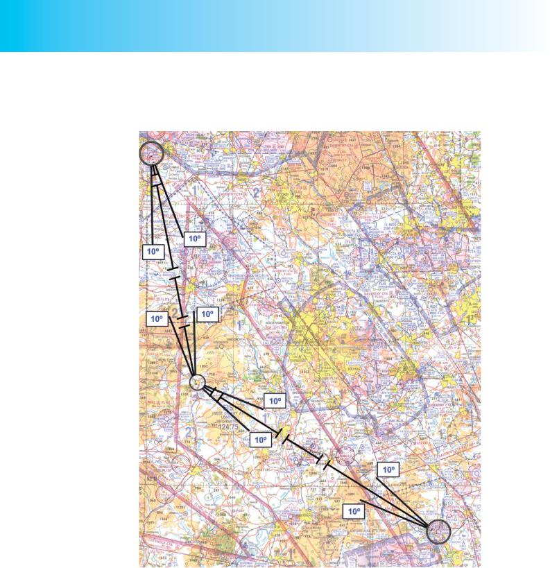
The colour of the track line is a personal choice but it must stand out clearly on the chart. (Note that if you fly at night, red lines will not be easily discernible on your chart.)
Figure 12.7 Drawing the planned track on the chart.
It is a good idea to draw small circles around your destination and departure aerodromes and any turning points as shown in Figure 12.7. This will ensure that these features are not obscured by the tracks. Do not make the track lines too thick as they may hide vital information on the chart. As you learnt in earlier chapters, it is a good idea, too, to “break” the track lines at checkpoints along the track that you plan to use as fixes. We will return to the subject of checkpoints and fixes shortly.
216