


98 |
L. E. Romero Martín et al. |
enormous, diverse, and vulnerable heritage of the terraces, which are an example of a cultural landscape whose history reveals the isolation, scarcity, subsistence, and identity of La Gomera islanders, as well as the terraces’ current state of abandonment and degradation. This research constitutes the beginning of an inventory process (identification, location, and description) which will serve as a prior step to classification and evaluation, necessary to protect this landscape. It is also the first contribution from an Atlantic-Macaronesian island to the atlas of world terraces, as promoted by the International Terraced Landscapes Alliance (ITLA).
7.1Introduction
Terraces with traditional walls are fine examples of locally developed architectural engineering. They are the most abundant type of dry stone construction in the world, and their study, protection and conservation are the main objective of the International Scientific Society for the interdisciplinary study of dry stone (French initials: SPS), founded in 1997. Additionally, thanks to the initiatives of public1 institutions and private associations,2 the traditional mode of construction with dry stone is in the process of obtaining recognition as a Bien de Interés Cultural by the Government of Spain and inclusion in UNESCO’s List of the Intangible Cultural Heritage of Humanity.
The terraces constitute cultural landscapes3, the result of the interaction of people and their environment over time and more specifically of the dynamic relationship between environmental limitations and socioeconomic opportunities. These landscapes belong to the “organically evolved” category (World Heritage Committee 1992) comprised of two subdivisions, relic and continuing, depending on the extent of the activity of their evolutionary process. The risk of fossilization is present in many territories where terraces have ceased fulfilling the active social function for which they were built. This last situation is particularly noticeable in islands, as in the Atlantic archipelagos, where there has been a rapid explosion over recent years in the service economy and tourism.
The cultural character of these landscapes is related to the concept of “heritage,” as manifested through the perception and evaluation that the corresponding society
1Resolution of September 2, 2016, of the Island Council of Mallorca (Balearic Islands), referring to the declaration as intangible cultural interest good of the traditional technique of construction with dry stone. Spanish Official State Gazette No. 224, September 16, 2016.
2The necessary legal steps to request the inclusion in the Intangible Cultural Heritage list by UNESCO were initiated by the French Federation of Dry Stone Professionals (FFPPS), who proposed to the SPS the request as a transnational nomination, in September 2016 (at the XV International Conference of Dry Stone, Greece). Eight countries have since been included in this initiative (Greece, France, Switzerland, Spain, Italy, Croatia, Slovenia, and Cyprus).
3As defined in the World Heritage Convention by UNESCO (1992).

7 Terraced Landscapes in the Canary Islands: La Gomera … |
99 |
has of their qualities, converting them into an element of identity4 (Hernández 2009). However, not all terraced landscapes are in the same phase of “social appropriation of the landscape” and, therefore, they have not all attained the same value in terms of heritage. They can be considered “heritage” once they fulfill three basic conceptual premises: when the corresponding society accepts the idea of collective ownership, when it acknowledges the material and cultural values of these landscapes, and when it ensures their values are preserved and handed down to subsequent generations (Silva 2009).
Some 22% of the cultural landscapes included in UNESCO’s Heritage of Humanity List (23 of 103) are terraced agricultural landscapes. Of these, ten are located in Europe, with four in Italy and one in Spain: the Cultural Landscape of Sierra de Tramuntana (Mallorca, Balearic Islands) incorporated in the list in 2011. In the Canary Archipelago, in only 7.5% of its Protected Nature Areas (11 of 146) are terraces considered basic elements for landscape protection and so included among essential and/or priority objectives (Romero et al. 2016).
An increased recognition of the value of these landscapes could potentially trigger their inclusion in the World Heritage list of terraced landscapes and, following the European Landscape Convention (Article 2), they would thus become “quotidian” landscapes, with acceptance of their heritage-based value and multifunctional character with resources that favor economic activity and sustainable development.
A heritage-centered analysis of these cultural terraced landscapes needs to incorporate their origin, historical evolution and social value, as well as a description of the resulting land structure (Silva 2009). It should begin with the identification and characterization of the area they occupy.5 Such identification includes their location and a delimitation of the geographical area, while their characterization comprises a description, analysis, and interpretation of the components of the landscape (physical environment and human action) and their interrelationships or processes.
Peru was one of the first countries to draw up a national inventory of terraces, thanks to the initiative of its National Office of Natural Resources Assessment (Spanish initials: ONERN) started in 1987 (Masson 1994). In Europe, through various projects that have considered terraced landscapes as an object of study, including MEDSTONE (Alomar et al. 2002), PATTER (Colomar 2002), TERRISC (Reynés 2007), and ALPTER (Fontanari and Patassini 2008), important advances have been made regarding their identification, cataloging, classification, and diagnostics in several countries in the southern and central parts of the continent.
The knowledge we have about the extension of terraced landscapes in Spain remains deficient despite studies undertaken by, for example, Grimalt and Blázquez (1989) in Sierra de Tramuntana (Mallorca), Rodríguez-Aizpeolea (1992) in Vall
4Idea extracted from Spain’s Plan Nacional de Paisaje Cultural (2012).
5Area identification and characterization form part of the commitment acquired by Spain when ratifying the European Landscape Convention (in force since 1st of March, 2008).

100 |
L. E. Romero Martín et al. |
d’Ebo municipality (Alicante), Asins (2009) in Petrer municipality (Alicante), and Lasanta (1989), Maiso and Lasanta (1990) and Lasanta et al. (2009) in the Aragonese Pyrenees and the Iberian System of La Rioja. In the Canary Islands, only the mapping of the area and typology of the Guiniguada basin (Gran Canaria) (Romero 2015) and of La Gomera Island have been performed (Plan Insular de Ordenación de La Gomera).
The terraces of La Gomera can be considered as an example of the expression of human adaptation to adverse topographical conditions. In this small island, the enormous amount of terraced landscapes results in a diverse landscape6 and toponymy (Perera 2015). The steep terraced slopes of Lepe (Agulo), Erque, and Erquito (Vallehermoso) are particularly noteworthy for their complicated environmental conditions. They have also been given other names, such as “Giant’s Stairway” (Sabaté 2012) and the “Machu Picchu of La Gomera” (Rodríguez 2012).
The aim of this work is to begin a heritage-based analysis of the cultural terraced landscapes of La Gomera Island. To this end, we have identified, mapped, and characterized the total terraced surface area in the island.
7.2Study Area
La Gomera is one of the smallest islands in the Canary archipelago (Spain), which is comprised of seven islands and is located in the NE Atlantic Ocean, opposite the northwest coastline of Africa (Fig. 7.1). La Gomera is the sixth largest island (369.8 km2) and the fourth highest (1487 m, Garajonay).
La Gomera is a volcanic island, although there has been no volcanic activity during the Quaternary (the last 2 million years). As a result, the island constitutes an “authentic museum of erosive volcanic landforms” (Carracedo 2008) including, most notably, sub-volcanic morphologies or sub-volcanic bodies in the form of abundant and spectacular dikes, stocks, and domes.
The island has an approximate age of 10–10.5 million years (Ancochea et al. 2006). It was constructed in three volcanic phases separated by two erosive periods, during which various volcanic structures overlapped and eroded. The oldest is the Miocene basaltic shield which experienced a giant landslide on its northern flank, followed by a trachyphonolitic stratovolcano that subsequently collapsed. Finally, from the most recent volcanic phase only Pliocene basalt lava traps have been preserved.
The island is an old massif with an elliptical plant shield form. Mid-range heights dominate (73.4% of its surface is between 200 and 1000 m above sea level), along with steep slopes (with 61.2% of them >12°), while flat surfaces are notable for their scarcity (Santana and Villalba 2008).
6Typology of terraced landscapes in La Gomera (AIDER La Gomera). Project “Custody of the territory.”
7 Terraced Landscapes in the Canary Islands: La Gomera … |
101 |
Fig. 7.1 Study area. Island of La Gomera
Its cliffed coast, which is surrounded by a shallow platform, the central high plateau and a radial network of incised ravines are its most significant topographical elements. Cliff height and coastal platform width attain their maximum values in the NNE section, due to greater exposure and the antiquity of the geological materials. The central plateau, located above 1000 m, constitutes the origin of most of the island’s numerous ravines.
The ravines and their water-divider lines present an unequal degree of incision and narrowness, respectively, according to the age of the materials and the characteristics of the rainfall. There are four types of ravine: mature wet, mature dry, young, and forest (Llánes et al. 2009). Ravines of the N and NE are the most incised, and their interfluves are narrow, while in the S and SW the ravines have wider riverbeds and their interfluves are quasi-horizontal.
Due to its subtropical Atlantic location (cold oceanic stream, Azores anticyclone, trade winds, and stratocumulus mantle) and its mountainous nature, there are significant climatic contrasts between different areas of La Gomera despite its reduced
102 |
L. E. Romero Martín et al. |
size. The annual mean temperature is 20 °C on the northern coast and 13 °C at the summits. Mean annual precipitation is low (450 mm, approximately), with average values for the southern coastal region of 200 mm/year and for the mid-northern mountainous region above 700 mm/year.
In accordance with climate variation with height, four types of zonal vegetation can be identified in the island (Del Arco et al. 2009): (1) coastal xerophilous shrubs formed of two plant communities: sweet spurge scrub (Neochamaeleo pulveru- lentae-Euphorbietum balsamiferae) and cardon scrub (Euphorbietum berthelotiicanariensis); (2) juniper woodland (Brachypodio arbusculae-Juniperetum canariensis); (3) laurel forest, formed of four plant communities: dry evergreen laurel forest (Visneo mocanerae-Arbutetum canariensis), humid evergreen laurel forest (Launaeo novocanariensis-Perseetum indicae), hygrophilous evergreen laurel forest (Diplazio caudati-Ocoteo foetentis), and cold evergreen laurel forest (Violo rivinianae-Myricetum fayae); and (4) pine woodland (Cisto gomerae-
Pinetum canariensis). In addition, there are some azonal plant communities conditioned by substrate characteristics: leafless spurge scrub (Euphorbietum aphyllae), canary palm grove (Periploco laevigatae-Phoenicetum canariensis), hydrophilic vegetation (Rubo-Salicetum canariensis), Plocama pendula scrub (Plocametum pendulae), tamarisk thicket (Atriplici ifniensis-Tamarici canariensis sigmetum), and rupicolous vegetation complexes. Human activities have degraded part of the vegetation of the island, generating natural secondary plant communities, such as
Euphorbio berthelotii-Schizogynetum sericeae, Euphorbietum berthelotii, Launaeo arborescentis-Schizogynetum sericeae, Rhamno crenulatae-Hypericetum canariensis, and Myrico fayae-Ericetum arboreae.
Natural and cultural values of the island have been acknowledged by a number of international, national and regional institutions. Spain declared Garajonay (a forest in the La Gomera summits) a National Park in 1981. The Canary Government has also established 17 Protected Nature Areas in the island (33% of its area). Likewise, at international level, UNESCO incorporated Garajonay as the first natural Spanish asset in its World Heritage List (1986) and La Gomera’s whistle language as an Intangible Cultural Heritage of Humanity in 2009, while the island in its entirety was declared a Biosphere Reserve in 2012.
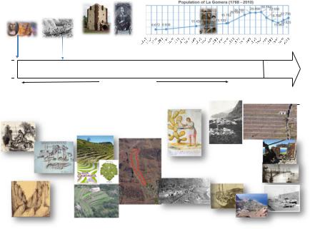
Human colonization of the island began around 500 BCE, with immigrants from Northern Africa. They were herders who also gathered seafood and vegetables, resulting in the first alteration to the island’s vegetation. However, human impact on the island’s natural resources increased radically after its conquest by the Spanish (1488). Over the subsequent centuries, the crops that were exported changed and were differentiated from the subsistence crops. Such changes were related to shifts in market demand, the adaptation of foreign species, and the gradual increase in population. The result of these changes is the current landscape, influenced by the intense establishment of terraces and crop spatial distribution (Fig. 7.2).
The biggest changes in La Gomera’s history took place over the course of the past century. A rapid growth in agricultural activity (mainly involving the banana and tomato plant) resulted in an extensive sprawl of terraces and a rise in population that reached its zenith in 1960 (30,784 inhabitants). The end of the century saw a
7 Terraced Landscapes in the Canary Islands: La Gomera … |
|
|
|
|
103 |
||||||||||||||||||
|
|
|
|
|
|
|
|
|
|
|
|
40,000 |
|
|
|
|
|
|
|
|
|
|
|
|
Columbus island |
Pirate attacks |
|
|
|
30,000 |
|
|
|
|
|
|
|
|
|
|
|||||||
1492 |
|
|
|
1599 |
|
|
|
|
20,000 |
|
|
|
|
|
|
|
|
|
|
||||
|
|
|
|
|
|
|
|
|
|
|
|
|
|
|
|
|
|
|
|||||
|
|
|
|
|
|
|
|
|
|
|
|
10,000 |
|
|
|
|
|
|
|
|
|
|
|
1 |
|
|
|
|
2 |
|
|
|
|
3 |
0 |
|
|
|
|
|
|
|
|
|
|
||
|
|
|
|
|
|
|
|
Peraza Count and |
|
|
|
|
|
|
|
|
|
|
|||||
|
|
|
|
|
|
|
|
|
|
|
|
|
|
|
|
|
|
|
|
|
|||
|
|
|
|
|
|
|
|
|
|
|
Beatriz de Bobadilla |
|
|
|
|
|
|
|
|
|
|
||
|
|
|
|
|
|
|
|
|
|
|
|
|
DEMOCRACY |
||||||||||
|
|
|
|
|
|
|
SEIGNEURIAL REGIME |
|
TYRANNICAL REGIME |
||||||||||||||
|
|
|
|
|
|
XVI |
|
|
|
XVII |
|
XVIII |
|
|
|
|
|
|
|
|
XXI |
||
|
|
|
|
|
|
|
|
|
|
|
XIX |
|
XX |
||||||||||
|
|
|
|
|
|
|
|
|
|
|
Agrarian economy |
|
|
|
|
|
Tourism and services |
||||||
|
|
|
|
|
|
|
|
|
|
|
AGRODIVERSITY |
|
|
|
EXPORT CROPS: |
|
EXPORT CROPS: BANANA AND TOMATOES |
|
|||||
|
|
|
|
|
|
EXPORT CROPS: |
|
|
|
>AGRODIVERSITY |
|
|
|
||||||||||
|
North African |
|
SUGAR |
|
|
VINE (windward |
|
for subsistence |
|
COCHINILLA |
|
MAXIMUM TERRACE EXISTENCE IN LOW |
|
||||||||||
|
human groups |
|
|
|
|
|
|
|
|||||||||||||||
|
SUBSISTENCE |
|
|
coast) |
|
TRADE (vine and |
|
(dry land crop, |
|
|
PLACES |
|
|
||||||||||
|
Shepherds |
|
|
|
|
|
|
|
|
||||||||||||||
|
|
CROPS: |
|
CEREALS (leeward |
|
cereals) WITH |
|
leeward) |
|
|
|
|
|
|
|||||||||
|
and gatherers |
|
|
|
|
|
|
|
|
|
|
||||||||||||
|
CEREALS; FRUIT |
|
|
middle mountain |
|
TENERIFE |
|
|
|
|
|
|
|
|
|
|
|||||||
|
|
|
|
|
|
|
|
|
|
|
|
|
|
||||||||||
|
(herbs, shells) |
|
|
|
|
|
|
|
|
|
|
|
|
|
|||||||||
|
|
TREES |
|
|
region) |
|
|
|
|
|
|
|
|
|
|
|
|
||||||
|
|
|
|
|
|
LOGGING: WOOD |
|
CORN-POTATOES |
|
INTENSE TERRACE |
|
|
|
|
|
|
|
|
|
|
|||
|
|
|
|
|
|
INCIPIENT |
|
|
(slopes, ravines) |
|
CONSTRUCTION |
|
|
|
|
|
|
|
|
|
|
||
|
|
|
|
|
|
TERRACE |
|
|
TERRACE |
|
EVEN IN NOT VERY |
|
|
|
|
|
|
|
|
|
|
||
|
|
|
|
|
|
CONSTRUCTION |
|
|
CONSTRUCTION |
|
FERTILE PLACES |
|
|
|
|
18 |
|
|
|
||||
|
|
|
|
|
|
IN RIVER BEDS |
|
|
|
|
|
|
|
|
|
|
|
|
|||||
|
|
|
|
|
|
|
|
|
|
|
|
|
|
|
|
|
|
||||||
|
|
|
|
|
|
|
|
|
|
|
|
|
|
|
|
|
|
16 |
|
|
19 |
|
|
|
|
|
|
|
|
|
|
|
|
|
|
|
|
|
|
|
|
||||||
6 |
|
|
|
|
|
|
|
|
|
|
|
|
14 |
|
|
Agricultural abandonment |
|
|
|
||||
|
|
|
|
|
|
|
|
|
|
|
|
|
|
|
|
in middle mountain region |
|
|
|
||||
|
|
|
|
|
|
|
|
|
9 |
|
|
|
|
|
|
|
Population littoralization |
|
|
|
|||
|
|
|
|
|
|
|
|
|
|
|
|
|
|
|
SUBSISTENCE |
|
|
|
Improvement in maritime |
|
|
|
|
|
|
8 |
|
|
|
|
|
|
|
|
CROPS: |
|
|
|
communications |
|
|
|
|||||
|
|
|
|
|
|
|
|
POLI-CROP |
|
|
|
Mass emigration |
|
|
|
||||||||
|
|
|
|
|
Orchilla |
|
|
|
|
|
|
|
|
|
|
|
|
(Venezuela and Tenerife) |
|
|
|
||
|
|
|
|
|
|
|
|
|
10 |
11 |
13 |
15 |
|
|
TOURISM AND SERVICES |
|
20 |
|
|||||
|
|
|
|
|
|
|
|
|
|
|
|
|
|
|
|
|
|||||||
|
|
|
|
|
|
|
|
|
|
|
|
17 |
|
|
|
|
|||||||
|
|
|
|
|
|
|
|
|
|
|
|
|
|
|
|
|
|
|
|||||
|
|
|
|
|
|
|
|
|
|
|
|
|
|
|
|
|
|
|
|
|
22 |
|
|
7 |
|
|
|
|
|
12 |
|
|
|
INDUSTRY |
|
|
|
|
|
||||||||
|
|
|
|
|
|
|
|
FISH FACTORIES |
|
21 |
|
|
|
|
|||||||||
Fig. 7.2 Timeline of the socioeconomic history of La Gomera. (List of sources used for the timeline: 1. http://iberoamericasocial.com/los-viajes-de-cristobal-colon-a-america/ [08/04/2017]. 2. http://www.gomeratoday.com/wp-content/uploads/2015/01/piratas-holandeses-en-la-gomera. jpg [08/04/2017]. 3. https://commons.wikimedia.org/wiki/File:Torre_del_Conde,_San_Sebasti% C3%A1n_de_la_Gomera,_La_Gomera,_Espa%C3%B1a,_2012-12-14,_DD_02.jpg [08/04/2017]. 4. http://www.guanches.org/enciclopedia/index.php?title=Archivo:Beatriz_de_Bovadilla.JPG [08/ 04/2017]. 5. http://images.eldiario.es/lagomeraahora/centro-Leoncio-Bento_EDIIMA20150605_ 0893_5.jpg [08/04/2017]. 6. http://i.bssl.es/unomasenlafamilia/2013/03/nombres-guanches.jpg [08/04/2017]. 7. http://3.bp.blogspot.com/- [08/04/2017]. 8. http://www.revistacanarii.com/ext/ img/molinotorriani.jpg [08/04/2017]. 9. Author: Juan Carlos Hernández Marrero. 10. http:// vinosyaceites.com/base/ui/imagenest/DO/do-la-gomera.gif [08/04/2017]. 11. http://www.eltambor. es/wp-content/uploads/2016/03/FORSTESRA-BLANCA.jpg [08/04/2017]. 12. http://gomeraverde. es/upload/img/periodico/img_50431.jpg [08/04/2017]. 13. Author: Juan Carlos Hernández Marrero. 14. http://www.museosdetenerife.org/assets/images/events/event–c705f43153.jpg [08/04/2017]. 15. http://images.eldiario.es/lagomeraahora/Rajita_EDIIMA20150211_0205_5.jpg [08/04/2017]. 16. https://www.facebook.com/isladelagomera/photos/a.174249062602488.43727.154491724578222/ 524423120918412/?type=3&theater [08/04/2017]. 17. http://lh3.ggpht.com/-XFkNQA4LnR0/ T5doCsBJd- [08/04/2017]. 18. Author: Juan Carlos Hernández Marrero. 19. Author: Concepción Fagundo García. 20. http://images.eldiario.es/lagomeraahora/Antigua-fotografia-pescante- Vallehermoso_EDIIMA20140503_0297_4.jpg [08/04/2017]. 21. http://vallegranrey.es/wp-content/ uploads/2014/11/litoral-1080x675.jpg [08/04/2017]. 22. http://www.eltambor.es/wp-content/ uploads/2014/09/Le%C3%B3n-y-Castillo-atracando-y-del-La-Palma-saliendo-en-junio-de-1958- en-el-puerto-de-San-Sebasti%C3%A1n-de-La-Gomera.jpg [08/04/2017])