

prt%3A978-0-387-35973-1%2F16
.pdfMulticriteria Decision Making, Spatial |
751 |
(a, b), a concordance index C(a, b) [0,1] Ð measuring the power of criteria that are in favor of the assertion aSb Ð and a discordance index ND(a, b) [0,1] Ð measuring the power of criteria that are opposed to aSb Ð are computed. Then, the relation S is deÞned as follows:
C(a, b) ≥ cˆ
ˆ
ND(a, b) < qd
ˆ ˆ
where c and d are the concordance and the discordance thresholds, respectively. Often an exploitation phase is needed to extract information from S on how alternatives compare to each other. At this phase, the concordance C(a, b) and discordance ND(a, b) indices are used to construct an index σ (a, b) [0,1], representing the credibility of the proposition aSb, (a,b) A × A. The proposition aSb holds if σ (a,b) is greater or equal to a given cutting level, λ [0.5,1].
In the continuous formulation of a multicriteria problem, decision rules implicitly deÞne the set of alternatives in terms of a set of objective functions and a set of constraints imposed on the decision variables. Here, multiobjective mathematical programming is often used. A multiobjective mathematical program is a problem where the aim is to Þnd a vector x Rp satisfying constraints of type
hi(x) < q0 ; (i = 1, 2, . . . , n) ,
respecting eventual integrity conditions and optimizing the objective functions:
zj(x) , j = 1, 2, . . . , m .
The general form of a multiobjective mathematical program is as follows:
Optimize [z1(x), z2(x), . . . , zm(x)] hi(x) < q0 (i = 1, . . . , n)
x X
A multiobjective mathematical program is in fact a multicriteria decision problem where [14]: (i) A = {x: hi(x) ≤ 0, i} Rp is the set of decision alternatives and (ii) F = {z1(x),z2(x),· · · ,zm(x)} is a set of criteria where each criterion is expressed by an objective function in terms of the decision variables.
Sensitivity/Robustness Analysis The analysts should examine, through sensitivity analysis, the stability of results with respect to the variation of different parameters. Sensitivity analysis is the basis for robustness analysis. There are several proposals to enhance GIS-based multicriteria decision making with sensitivity analysis proce-
dures (e. g., [3]). Robustness analysis in multicriteria decision making is a relatively new research topic. Proposals for enhancing GIS-based multicriteria decision making with robustness analysis are still lacking.
Final Recommendation The Þnal recommendation in multicriteria analysis may take different forms according to the manner in which a problem is stated. Roy [12] identiÞes four types of results corresponding to four ways for stating a problem: (i) choice: selecting a restricted set of alternatives, (ii) sorting: assigning alternatives to different predeÞned categories, (iii) ranking: classifying alternatives from best to worst with eventually equal positions or (iv) description: describing the alternatives and their follow-up results.
Key Applications
GIS-based multicriteria analysis is used in a wide range of decision and management situations. In a recent literature review, Malczewski [10] enumerates about 319 papers devoted to GIS-based multicriteria analysis between 1990 and 2004. The complete list of these papers is available at http://publish.uwo.ca/~jmalczew/gis-mcda.htm.
Environment Planning and Ecology Management |
M |
GIS-multicriteria evaluation has been intensively used in |
|
environment planning and ecology management. Most |
|
analyses within this application area concern land suitabil- |
|
ity, resource allocation, plan/scenario evaluation, impact |
|
assessment and site search/selection problems. |
|
Transportation |
|
Within the transportation application domain, GIS-based |
|
multicriteria evaluation is used essentially in vehicle rout- |
|
ing and scheduling, and land suitability problems. |
|
Urban and Regional Planning |
|
Major uses of GIS-multicriteria analysis in urban and |
|
regional planning concern resource allocation, plan/ |
|
scenario evaluation, site search/selection and land suitabil- |
|
ity problems. |
|
Waste Resource Management |
|
The problems tackled in this application domain con- |
|
cern land suitability, plan/scenario evaluation and site |
|
search/selection. |
|
Hydrology and Water Resources |
|
In the hydrology and water resources application |
|
domain, GIS-multicriteria analysis is used essentially for |
|
plan/scenario evaluation. There are also some works for |
|
site search/selection and land suitability problems. |
|

752 Multicriteria Decision Making, Spatial
Forestry
Major problems tackled within the forestry application domain are land suitability, site search/selection and forestry resources allocation.
Agriculture
The problems considered here are essentially land suitability for different agricultural uses and resources allocation for agricultural activities. Some works are concerned with site search/selection and plan/scenario evaluation problems.
Natural Hazard Management
The problems considered within this application domain mainly concern land suitability and plan/scenario evaluation.
Recreation and Tourism Management
Within this application area, the most treated problem is site search/selection.
Health Care Resource Allocation
Major works in this application domain concern health care site search/selection.
Housing and Real Estate
The problems that are treated here concern land suitability for habitat and real estate, plan/scenario evaluation and site selection for habitation restoration.
Future Directions
There are many important proposals concerning GISbased multicriteria spatial decision making. However, these proposals present some limitations that prevent them from going beyond the academic contexts. Some of these limitations are cited in the following section.
Integration of Utility-Based Decision Rules
A major part of GIS and multicriteria analysis integration works use utility-based decision rules. However, outranking relation-based decision rules are generally more appropriate to deal with ordinal aspects of spatial decision problems. The natural explanation for this is that the outranking relation-based decision rules have computational limitations with respect to the number of alternatives they consider [11]. One possible solution to facilitate the use of decision rules based outranking relation is to reduce the
number of potential alternatives. The idea that is generally used consists of subdividing the study area into a set of homogenous zones which are then used as decision alternatives or as a basis for constructing these alternatives.
Spatial and Temporal Dimensions
in Multicriteria Modeling
Two points need to be addressed here: the construction of criteria involving divergent consequences and the modeling of preferences that vary across time and space. In the literature, there are some papers that deal with the construction of criteria based on divergent consequences and the modeling of time-dependent preferences. With respect to GIS-based multicriteria analysis, there are a few papers that take these aspects into account [3].
Fuzzy Spatial Multicriteria Decision Making
Malczewski [10] estimates that 77% of the papers that were published between 1990 and 2004 related to GIS multicriteria analysis used deterministic information. There are several plans to incorporate multicriteria methods supporting imprecision, uncertainty and fuzziness into GIS [6]. The integration of such methods in a geographical information system has the potential to enhance its analytical strength.
Multicriteria Group Spatial Decision Making
Spatial decision problems naturally involve several different kinds of stakeholders. However, the majority of the GIS-multicriteria articles consider individual decision makerÕs approaches and only a few works (e. g., [5]) are devoted to multicriteria group spatial decision making.
Web-Based Multicriteria Spatial Decision Making
There is an increasing interest in the development of Webbased GIS multicriteria evaluation systems [1]. Research on this topic is worthwhile since it promotes the sharing and access of geographical information and facilitates multicriteria collaborative spatial decision making.
Cross References
Data Analysis, Spatial
Decision-Making Effectiveness with GIS
Internet GIS
Multicriteria Spatial Decision Support Systems
Raster Data
Sensitivity Analysis
Temporal GIS and Applications
Uncertainty, Modeling with Spatial and Temporal

Multicriteria Spatial Decision Support Systems |
753 |
Vector Data
Web Services, Geospatial
Recommended Reading
1.Carver, S.: Developing web-based GIS/MCE: Improving access to data and spatial decision support tools. In: Thill, J.C.(eds.) Multi-criteria decision-making and analysis: A geographic information sciences approach, pp. 49Ð75. Ashgate Publishing Ltd., Aldershot, United Kingdom (1999)
2.Chakhar, S., Martel, J.M.: Enhancing geographical information systems capabilities with multi-criteria evaluation functions. J Geogr Inf Decis Anal 7(2), 47Ð71 (2003)
3.Feick, R.D., Hall, B.G.: A method for examining the spatial dimension of multicriteria weight sensitivity. Int J Geogr Inf Sci 20(7), 703Ð726 (2004)
4.Figueira, J., Greco, S., Ehrgott, M.: Multiple Criteria Decision Analysis: State of the Art Surveys. Springer-Verlag, New York (2005)
5.Jankowski, P., Andrienko, N., Andrienko, G.: Map-centered exploratory approach to multiple criteria spatial decision making. Int J Geogr Inf Sci 15, 101Ð127 (2001)
6.Jiang, H., Esatman, J.R.: Applications of fuzzy measures in multi-criteria evaluation in GIS. Int J Geogr Inf Sci 14(2), 173Ð184 (2000)
7.Keeney, R.L., RafÞa, H.: Decisions with multiple objectives: Preferences and value trade-offs. John Wiley & Sons, New York (1976)
8.Keeney, R.L.: Valued-focused thinking: A path to creative decision. Harvard University Press, Cambridge, USA (1992)
9.Malczewski, J.: GIS and multicriteria decision analysis. John Wiley & Sons, New York (1999)
10.Malczewski, J.: A GIS-based multicriteria decision analysis: A survey of the literature. Int J Geogr Inf Sci 20(7), 703Ð726 (2006)
11.Marinoni, O.: A discussion on the computational limitations of outranking methods for land-use suitability assessment. Int J Geogr Inf Sci 20(1), 69Ð87 (2006)
12.Roy, B.: Multicriteria methodology for decision aiding. Kluwer Academic Publishers, Dordrecht (1996)
13.Saaty, T.L.: The analytic hierarchy process. McGraw-Hill, New York (1980)
14.Vincke, P.H.: Multicriteria decision-aid. John Wiley & Sons, Chichester (1992)
Multicriteria Spatial
Decision Support Systems
SALEM CHAKHAR, VINCENT MOUSSEAU
LAMSADE, University of Paris Dauphine, Paris, France
Synonyms
Spatial multicriteria decision support systems
Definition
A spatial decision support system (SDSS) is an interactive, computer-based system designed to support a user
or a group of users in achieving a higher effectiveness of decision making while solving a semi-structured spatial decision problem [10]. It lies at the intersection of two major trends in the spatial sciences: geographic information sciences and spatial analysis [10]. What really differentiates a SDSS and a traditional decision support system (DSS) is the particular nature of the geographic data considered in different spatial problems and the high level of complexity of these problems. An effective SDSS requires enhancing conventional DSS with a range of speciÞc techniques and functionalities used especially to manage spatial data. According to [5], a SDSS should (i) provide mechanisms for the input of spatial data, (ii) allow representation of spatial relations and structures, (iii) include the analytical techniques of spatial analysis, and (iv) provide output in a variety of spatial forms, including maps.
Multicriteria spatial decision support systems (MC-SDSS) can be viewed as part of the broader Þelds of SDSS. The speciÞcity of MC-SDSS is that it supports spatial multicriteria decision making. Spatial multicriteria decision making refers to the use of multicriteria analysis (MCA) in the context of spatial decision problems. MCA [7] is a family of operations research tools that have experienced
very successful applications in different domains since the M 1960s. It has been coupled with geographical information systems (GIS) since the early 1990s for enhanced decision making.
Historical Background
The concept of SDSS has evolved in parallel with DSSs [12]. The Þrst MC-SDSS were developed during the late 1980s and early 1990s [10]. Early research on MCSDSS is especially devoted to the physical integration of the GIS and MCA. These Þrst tools emphasize interactively and ßexibility since GIS and MCA softwares are coupled indirectly through an intermediate system. Later research concerns the development of MC-SDSS supporting collaborative and participative multicriteria spatial decision making [9]. Web-based MC-SDSS is an active research topic which will be the subject of considerable interest in the future [2].
Scientific Fundamentals
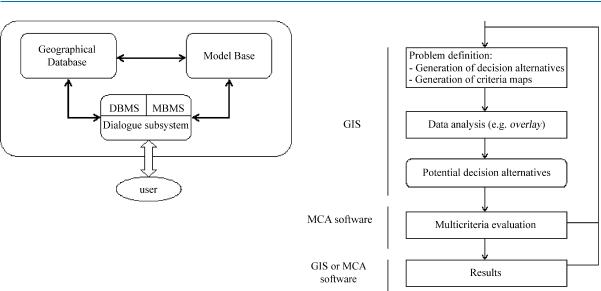
General Structure of SDSS/MC-SDSS
A typical SDSS contains three generic components [10] (see Fig. 1): a database management system and geographical database, a model-based management system and model base, and a dialogue generation system. The data management subsystem performs all data-related tasks; that is, it stores, maintains, and retrieves data from the
754 Multicriteria Spatial Decision Support Systems
Multicriteria Spatial Decision Support Systems, Figure 1 |
General |
structure of SDSS [10] |
|
database, extracts data from various sources, and so on. It provides access to data as well as all of the control programs necessary to get those data in the form appropriate for a particular decision making problem. The model subsystem contains the library of models and routines to maintain them. It keeps track of all possible models that might be run during the analysis as well as controls for running the models. The model base management system component provides links between different models so that the output of one model can be the input into another model. The dialogue subsystem contains mechanisms whereby data and information are input into the system and output from the system. These three components constitute the software portion of the SDSS. A fourth important component of any decision support system is the user which may consist of simple users, technical specialists, decision makers and so on.
MC-SDSS can be viewed as a part of a broader Þeld of SDSS. Accordingly, the general structure of a MC-SDSS is the same as that of a SDSS. However, the model-based management system is enhanced to support multicriteria spatial modeling and the model base is enriched with different multicriteria analysis techniques.
GIS and Multicriteria Analysis Integration Modes
The conceptual idea on which most of GIS-based multicriteria analysis relies is to use the GIS capabilities to prepare an adequate platform for using multicriteria methods [3] (see Fig. 2). The GIS-based multicriteria analysis starts with the problem identiÞcation, where the capabilities of the GIS are used to deÞne the set of feasible alternatives and the set of criteria. Then, the overlay procedures are used in order to reduce an initially rich set of alternatives into a small number of alternatives which are easily evaluated by using a multicriteria method. Finally, the drawing
Multicriteria Spatial Decision Support Systems, Figure 2 Conceptual schema for GIS and multicriteria analysis integration
and presenting capabilities of the GIS are used to present results.
Physically, there are four possible modes to integrate GIS and multicriteria analysis tools [3,10,13]: (i) no integration, (ii) loose integration, (iii) tight integration, and (iv) full integration. The Þrst mode corresponds to the situation that dominated until the late 1980s, when the GIS and multicriteria analysis were used independently to deal with spatial problems. The next three modes correspond to increasing levels of complexity and efÞciency (see Fig. 3).
Loose Integration Mode The integration of GIS software and a stand-alone multicriteria analysis software application is made possible by the use of an intermediate system. The intermediate system permits the reformulation and restructuring of the data obtained from the overlapping analysis performed through the GIS, and is converted into a form that is convenient to the multicriteria analysis software. The other parameters required for the analysis are introduced directly via the multicriteria analysis software interface. The results of the analysisÑtotally made in the multicriteria analysis softwareÑmay be visualized by using the presentation capabilities of the multicriteria analysis package, or feedback to the GIS part, via the intermediate system, for display and, eventually, for further manipulation. Each part has its own database and its own interface, which limits the user-friendliness of the system.
Tight Integration Mode In this mode, a particular multicriteria analysis method is directly added to the GIS

Multicriteria Spatial Decision Support Systems |
755 |
Multicriteria Spatial Decision Support Systems, Figure 3 GIS and multicriteria loose (a), tight (b) and full (c) integration modes [3,10]
software. The multicriteria analysis method constitutes an integrated but autonomous part with its own database. The use of the interface of the GIS part alone increases the interactivity of the system. This mode is the Þrst step toward a complete GIS-multicriteria analysis integrated system. Yet, with the autonomy of the multicriteria analysis method, the interactivity remains a problem.
Full Integration Mode The third mode yields itself to a complete GIS-multicriteria analysis integrated system that has a unique interface and a unique database. Here, the multicriteria analysis method is activated directly from the GIS interface, as any GIS basic function. The GIS database is extended so as to support both the geographical and descriptive data, on the one hand, and the parameters required for the multicriteria evaluation techniques, on the other hand. The common graphical interface enhances the user-friendless of the global system.
GIS and Multicriteria Analysis Interaction Directions
It is possible to distinguish Þve different directions of interaction [11,13]: (i) no interaction, (ii) one-directional interaction with the GIS as the main software (iii) one-direc- tion interaction with the multicriteria tool as the main software, (iv) bi-directional interaction, and (v) dynamic interaction. One-directional interaction provides a mechanism for importing and exporting information via a single ßow that originates either in the GIS or multicriteria software. This type of interaction can be based on GIS or multicriteria as the main software. In the bi-directional interaction approach, the ßow of data and information can both originate and end in the GIS and multicriteria decision making modules. Dynamic integration allows for a ßexible moving of information back and forth between the GIS and multicriteria modules according to the userÕs needs.
Design of a MC-SDSS
Different frameworks for designing MC-SDSS have been proposed in the literature [3,9,10]. Apart from differences
in GIS capabilities and multicriteria techniques, most of these frameworks contain the major components introduced earlier. In the rest of this section, a revised version of the framework proposed in [3] is presented. This framework is conceived of in such a way that it supports GISMCA integration and is also open to incorporating any other OR/MS tool into the GIS (see Fig. 4).
Spatial Database Management System The spatial database management system is an extension of the conventional database base management system. It is used M specially to manage spatial data.
Geographic Database The geographic database is an extended GIS database. It constitutes the repository for both (i) the spatial and descriptive data, and (ii) the parameters required for the different OR/MS tools.
Model Base The model base is the repository of different analytical models and functions. These functions include the basic functions of a GIS, including statistical analysis, overlaying, spatial interaction analysis, network analysis, etc. The model base also contains other OR/MS models and perhaps the most important ones are multicriteria analysis tools. The system is also open to including any other OR/MS tool (e. g., mathematical models, simulation and prediction models, etc.), or any other ad hoc model developed by the model construction block.
Model Management System The role of this component is to manage the different analysis models and functions. The model management system contains four elements: the meta-model, the model base management system, the model construction block and the knowledge base.
Meta-Model This element is normally an expert system used by the decision maker to explore the model base. This exploration enables the decision maker to perform a Òwhat-ifÓ analysis and/or to apply different analytical

756 Multicriteria Spatial Decision Support Systems
Multicriteria Spatial Decision Support Systems, Figure 4 A design of a multicriteria SDSS
functions. The meta-model uses a base of rules and a base of facts incorporated into the knowledge base. The notion of the meta-model is of great importance in the sense that it makes the system open for the addition of any OR/MS analysis tool. This requires the addition of the characteristics of the analytical tool to the base of rules, and, of course, the addition of this model to the model base.
Knowledge Base The knowledge base is the repository for different pieces of knowledge used by the meta-model to explore the model base. The knowledge base is divided into a base of facts and a base of rules. The base of facts contains the facts generated from the model base. It also contains other information concerning the uses of different models, the number and the problems to which each model is applied, etc. The base of rules contains different production rules which are obtained from different experts, or automatically derived by the system from past experiences. For instance, this base may contain the following rule: If the problem under study is the concern of many parties having different objective functions, then the appropriate tool to apply is multicriteria analysis (MCA).
Model Base Management System The role of the model base management system is to manage, execute and integrate different models that have been previously selected by the decision maker through the use of the meta-model.
Model Construction Block This component gives the user the possibility to develop different ad hoc analysis models for some speciÞc problems. The model that is developed can then be added directly to the model base and its characteristics can be introduced into the knowledge base.
Spatial Data Mining and Spatial on Line Analytical Processing Data mining and on line analytical processing (OLAP) have been used successfully to extract relevant knowledge from huge traditional databases. Recently, several authors have been interested in the extension of these tools in order to deal with huge and complex spatial databases. In particular, [6] underlines that spatial data mining is a very demanding Þeld that refers to the extraction of implicit knowledge and spatial relationships which are not explicitly stored in geographical
Multicriteria Spatial Decision Support Systems |
757 |
databases. The same author adds that spatial OLAP technology uses multidimensional views of aggregated, prepackaged and structured spatial data to give quick access to information. Incorporating spatial data mining and spatial OLAP into the MC-SDSS will undoubtedly ameliorate the negative impacts when the quality of data is a problem and, consequently, add value to the decision-making process.
Dialogue System The dialogue system represents the interface and tools used to support the dialogue between the user and the MC-SDSS. It permits the decision maker to enter queries and to retrieve the results.
Key Applications
MC-SDSS have been used in a wide range of practical applications of spatial multicriteria decision making problems. They include nuclear waste disposal facility location, solid waste management, land-use planning, corridor location, water resource management, residential site development, health care resource allocation and land suitability analysis. In the rest of this section, a brief description of some SDSS are provided.
¥OSDM (Open Spatial Decision Making) [1] is an Internet-based MC-SDSS designed to support the selection of suitable sites for radioactive waste disposal by the public in Great Britain. An important characteristic of OSDM is that it does not require prior knowledge of GIS or MCA.
¥Spatial Groupe Choice (SGC) [9] is a GIS-based decision support system for collaborative spatial decision support making. The system has been successfully used for residential site selection in the Duwamish Waterway and surrounding areas, and for health care resource allocation.
¥IDRISI/Decision Support is a built-in decision support module for performing multicriteria decision analysis. This system has been applied in different real world applications. The case study described in [10] illustrates the use of the system for analyzing land suitabillity for a housing project in Mexico.
¥DOCLOC has been designed for aiding health practitioners in the selection of practices in the state of Idaho [8]. One limitation to this system is the use of the loose coupling strategy.
¥Collaborative Planning Support System (CPSS) [14] provides an example of a system employing multiobjective fuzzy decision analysis. It is a multicriteria collaborative spatial decision support system for sustainable water resource management.
Future Directions
Use Full Integration Modes
The Þrst limitation concerning MC-SDSS is relative to the integration mode adopted. In fact, most of the proposed works use loose or tight integration modes. One possible solution to permit full integration is to identify a restricted set of multicriteria evaluation functions and incorporate them into the GIS [3]. These functions represent elementary operations required to implement the major part of multicriteria methods. This integration strategy avoids the necessity of programming the different multicriteria methods. In addition, it permits a full integration since the multicriteria evaluation functions are generic and can easily be incorporated in the available commercial GIS.
Incorporation of Large Number
of Multicriteria Methods
It is well established that each multicriteria method has |
|
|
its advantages and disadvantages. This means that a giv- |
|
|
en method may be useful in addressing some problems |
|
|
but not in others. One intuitive solution to this problem |
|
|
M |
||
is to incorporate as many multicriteria methods in the MC- |
||
SDSS as possible. However, this idea has several limita- |
|
|
tions: (i) the obtained system is not ßexible enough, (ii) it |
|
|
requires a considerable effort for programming the differ- |
|
|
ent methods, and (iii) there is no way to develop Òperson- |
|
|
alizedÓ methods. The integration strategy proposed in the |
|
|
previous paragraph permits the overall system to handle |
|
|
this limitation. In fact, the multicriteria evaluation func- |
|
|
tions are deÞned in a generic way and can be used to imple- |
|
|
ment different multicriteria methods or even to create ad |
|
|
hoc methods adapted to the problem under consideration. |
|
|
Formal Methodology to Select |
|
|
the Multicriteria Method to Apply |
|
|
Employing a large number of multicriteria methods in |
|
|
the MC-SDSS permits the extension and reinforcement of |
|
|
the analytical potential of the GIS. However, a new prob- |
|
|
lem appears: how to choose the method to use in a given |
|
|
problem? There are generally three possible solutions to |
|
|
the multicriteria method selection problem: (i) the use of |
|
|
a classiÞcation tree (ii) the use of a multicriteria method, |
|
|
and (iii) the use of an expert system or a decision support |
|
|
system. It is thought that the last solution is more appro- |
|
|
priate from the perspective of GIS and multicriteria analy- |
|
|
sis integration. The development of a rule-based system |
|
|
needs the designers to work out (i) the characterization |
|
|
of the spatial decision problems, the multicriteria methods |
|
|
and the decision maker(s) (ii) the identiÞcation and quan- |
|

758 Multi-Dimensional Access Structures
tiÞcation of knowledge about multicriteria methods, and (iii) the establishment of correspondences among the elements enumerated in (i). The result is a collection of rules. These last ones are then used by the inference system as a basis for selecting the most appropriate method.
Choice of the Standardization/Weighting Techniques
Among the problems that are not sufÞciently treated in GIS-based multicriteria systems is the selection of the standardization and the weighting techniques. There are many different standardization/weighting techniques that can be used in MC-SDSS. It is important to note that different standardization/weighting techniques may lead to different results. The development of a formal framework for aiding the decision maker during the selection of the standardization/weighting techniqueÑsimilar to the one proposed for the selection of the multicriteria methodÑis a good initiative.
Developing a Multicriteria
Spatial Modeling Environment
The use of multicriteria analysis in the GIS is complicated by the lack of an appropriate multicriteria spatial modeling environment. A possible solution is to develop a script-like programming language that supports the different multicriteria evaluation functions. DMA, decision map algebra, proposed in [4] and inspired from TomlinÕs [15] map algebra, seems to be a good starting point.
Web-Based Multicriteria Spatial Decision Making
Web-based MC-SDSS is a recent and active research topic [2]. This is particularly important since it permits the sharing of geographical information and facilitates multicriteria collaborative spatial decision making.
Cross References
Data Analysis, Spatial
Multicriteria Decision Making, Spatial
Recommended Reading
1.Carver, S.J.: Open spatial decision making on the Internet. School of Geography, University of Leeds, Yorkshire, England (1996)
2.Carver, S.J.: Developing web-based GIS/MCE: improving access to data and spatial decision support tools. In: Thill, J.C. (eds.) Multi-criteria decision-making and analysis: A geographic information sciences approach, pp. 49Ð75. Ashgate, Aldershot, England (1999)
3.Chakhar, S., Martel, J.M.: Enhancing geographical information systems capabilities with multi-criteria evaluation functions. J. Geogr. Inf. Dec. Anal. 7(2), 47Ð71 (2003)
4.Chakhar S., Mousseau, V.: DMA: An algebra for multicriteria spatial modeling. In: Proccedings ICA Workshop on Geospatial Analysis and Modeling, 8 July, pp. 155Ð185, Vienna, Austria (2006)
5.Densham, P.J.: Spatial decision support systems. In: Maguitre, D.J., Goodchild, M.F., Rhind, D. (eds.) Geographical information systems: Principles and applications, vol. 1, pp. 403Ð412, Longman, London (1991)
6.Faiz, S.: Managing geographic data quality during spatial data mining and spatial olap. data warehousing and data quality. GIM Int 14(12), 28Ð31 (2000)
7.Figueira, J., Greco, S., Ehrgott, M.: Multiple criteria decision analysis: State of the art surveys. Springer-Verlag, New York (2005)
8.Jankowski, P., Ewart, G.: Spatial decision support system for health practitioners: Selecting a location for rural health practice. Geographical Systems 3(2), 297Ð299 (1996)
9.Jankowski, P., Nyerges, T.L., Smith, A., Moore, T.J., Horvath, E.: Spatial group choice: A SDSS tool for collaborative spatial deci- sion-making. International Journal of Geographical Information Systems 11, 566Ð602 (1997)
10.Malczewski, J.: GIS and multicriteria decision analysis. John Wiley & Sons, New York (1999)
11.Malczewski, J.: A GIS-based multicriteria decision analysis: A survey of the literature. International Journal of Geographical Information Science 20(7), 703Ð726 (2006)
12.G.M. Marakas, G.M.: Decision support systems in the 21st centry, 2nd edn. Prentice-Hall, Upper Saddle River (2003)
13.Nyerges, T.L.: Coupling GIS and spatial analytic models. In: Breshanan, P., Corwin, E., Cowen, D. (eds.) Proceedings of the 5th International Symposium on Spatial Data Handling. pp. 534Ð543. Charleston, SC. Humanities and Social Sciences Computing Laboratory, University of South Carolina (1992)
14.Simonovic, S.P., Bender, M.J.: Collaborative planning-support system: An approach for determining evaluation criteria. Journal of Hydrology 177(3Ð4), 237Ð251 (1996)
15.Tomlin, C.D.: Geographic information systems and cartographic modeling. Prentice Hall, Englewood Cliffs, New Jersey, USA (1990)
Multi-Dimensional Access Structures
Indexing, High Dimensional
Multidimensional Index
Indexing, Hilbert R-tree, Spatial Indexing, Multimedia Indexing
Multi-Dimensional Indexing
Indexing, High Dimensional
Multi-Dimensional Mapping
Space-Filling Curves

Multimedia Atlas Information Systems |
759 |
Multi-Dimensional Time Series Similarity
Trajectories, Discovering Similar
Multilateration
Indoor Localization
Multimedia Atlas Information Systems
LORENZ HURNI
Institute of Cartography, ETH Zurich, Zurich, Switzerland
Synonyms
Cartographic information system; Atlas information system; Atlas, electronic; Atlas, interactive; Atlas, multimedia; Atlas, virtual; Google Earth; Digital Earth
Definition
Multimedia atlas information systems (MAIS) are systematic, targeted collections of spatially related knowledge in electronic form, allowing a user-oriented communication for information and decision-making purposes. As in a conventional atlas, a MAIS mainly consists of a harmonized collection of maps with different topics, scales, and/or from different regions. The maps usually come in standardized scales or degrees of generalization, respectively. The different map types have a common legend and symbolization. The access to the maps is granted through thematic or geographic indexes. MAIS dispose of special interactive functions for geographic and thematic navigation, querying, analysis and visualization in 2D and 3D mode. Unlike in many geographic information systems (GIS) applications, the data in MAIS is cartographically edited and the functionality is intentionally limited in order to provide a user-targeted set of data as well as adapted analysis and visualization functions. In multimedia atlases, additional related multimedia information, like graphics, diagrams, tables, text, images, videos, animations, and audio documents, are linked to the geographic entities. EfÞcient management of the increasing amount of information led to the development of database-driv- en MAIS. Most MAIS are based on CD-ROM, DVD or increasingly on web technologies (intranet, internet).
Historical Background
The technological leap, which caused the transition from analog to digital cartography in the 1980s, has also stimulated the development of interactive atlases. GIS, comput-
Multimedia Atlas Information Systems, Table 1 Aspects of cartographic expression forms, after [3]
Aspects of cartographic |
Ordering of aspects |
expression forms |
|
Display media |
Print, screen, projection |
Dimension of |
2D, pseudo-3D, 3D |
representation |
|
|
|
Degree of dynamics |
Static, cinematographic, dynamic |
Degree of interaction |
Noninteractive, partially interactive, |
|
interactive |
Channels of representation |
Visual, acoustic, haptic |
UserÐmap relation |
Separating, integrative, ampliÞcation of |
|
reality |
|
|
er aided design (CAD) systems, desktop publishing (DTP) |
|
|
systems and the thereby-evoked releases of geometric and |
|
|
thematic cartographic data were the catalysts of both dig- |
|
|
ital and interactive cartography. It is disputed which atlas |
|
|
was the Þrst digital one: Some authors claim an early ver- |
|
|
sion of the Electronic Atlas of Canada was the Þrst digital |
|
|
atlas [1], others consider that it was the Electronic Atlas |
|
|
of Arkansas [2]. Early digital atlases had a rather limit- |
|
|
M |
||
ed functionality, like name search, zoom, and layer selec- |
||
tion. Other atlases like the PC version of the National Atlas |
|
|
of Sweden were based on commercial GIS software. In |
|
|
the following years, interactive atlases were evolving with |
|
|
respect to content, data and technology. In several coun- |
|
|
tries national atlases on CD-ROM were produced, either |
|
|
as a digital version of a conventional paper atlas (such |
|
|
as the National Atlas of Germany), or as entirely inter- |
|
|
active version (such as the Atlas of Switzerland). In the |
|
|
late 1990s, national mapping authorities began to publish |
|
|
their topographical map series on CD-ROM/DVD. A third |
|
|
group of atlases are counterpieces to conventional world or |
|
|
school atlases, such as Microsoft Encarta, which, however, |
|
|
is today integrated in the Encarta encyclopedia. Techno- |
|
|
logically, the Þrst atlases were based on raster data maps |
|
|
like most of the electronic national map series. Modern |
|
|
interactive atlases make use of vector data sets and/or sta- |
|
|
tistical data which are symbolized and visualized on the ßy |
|
|
(e. g., the Tirol Atlas). The atlases evolved from CD-ROM, |
|
|
then DVD to web-based or combined interactive atlases. |
|
|
Scientific Fundamentals |
|
For the case of interactive maps on new media, the classical graphical variables and their expressions are extended as shown in Table 1 [3].
The added values and advantages of MAIS compared to paper atlases can be summed up as follows: interactivity, navigation, maps as interface, exploration, cus-

760 Multimedia Atlas Information Systems
Multimedia Atlas Information Systems, Table 2 Main functions in a multimedia atlas information system (MAIS) [6]
Function Groups |
Function subgroups |
Functions |
|
General functions |
|
Mode selection, language selection, Þle import/export, printing, placing bookmarks, hot spots, |
|
|
|
forward/backward, settings (preferences), tooltips, display of system state, help, imprint, |
|
|
|
home, exit |
|
Navigation functions |
Spatial navigation |
Spatial unit selection, enlarge/reduce of map extend (zoom in, zoom out, magniÞer), move |
|
|
|
map (pan, scroll), reference map/globe, map rotation, determination of location (coordinates, |
|
|
|
altitude), line of sight and angle, placement of pins, spatial/geographical index, |
|
|
|
spatial/geographical search, tracking |
|
|
|
|
|
|
Thematic navigation |
Theme selection and change, index of themes, search by theme, theme favorites |
|
|
|
|
|
|
Temporal navigation |
Time selection (positioning of time line, selection of time period), animation (start/stop etc.) |
|
Didactic functions |
Explanatory functions |
Guided tours, preview, explanatory texts, graphics, images, sounds, Þlms |
|
|
|
|
|
|
Self-control functions |
Quizzes, games |
|
Cartographic and |
Map manipulation |
Switch on/off layers, switch on/off legend categories, modiÞcation of symbolization, change |
|
visualization functions |
|
of projection |
|
|
Redlining |
Addition of user deÞned map elements, addition of labels (labeling) |
|
|
Explorative data analysis |
ModiÞcation of classiÞcation, modiÞcation of appearance/state (brightness, position of sun), |
|
|
|
map comparison, selection of data |
|
GIS functions |
Space and object |
Spatial query/position query (coordinates query/query of altitude), measurement/query of |
|
|
oriented query functions |
distance and area, creating proÞle |
|
|
Thematic query |
Thematic queries (data/attribute queries), access to statistical table data |
|
|
functions |
|
|
|
Analysis functions |
Buffering, intersection, aggregation and overlapping (transparent overlapping/fading), terrain |
|
|
|
analysis (exposition, slope etc.) |
|
|
|
|
|
tomized/customizable to userÕs need, updatable, dynamics/animation, multimedia integration [4,5].
The degree of interactivity, a very signiÞcant element of the usability of a cartographic application, is mainly based on the richness of available cartographic functions. Table 2 shows the most important functions, arranged in Þve main groups [6].
Complementary, MAIS can be characterized according to the basic concepts as shown in Table 3. Today, most atlases still consist of raster and vector base data, but a transition to relational or object-oriented vector data can be observed. Most atlases are still bound to classic computer interfaces like keyboards, mice and screens. Internet and mobile technologies will increase the degree of system distributivity. With respect to interactivity, atlases are arranged into three groups: View-only atlases, interactive atlases and analytical atlases [7]. The latter can be subdivided into simple, constructive, and automatic analytical atlas types [8]. Furthermore, many atlases serve no longer as a main, but as one out of several possible interfaces to the data, e. g., in the Encarta encyclopedia.
TodayÕs MAIS comprise of basic topographic and thematic data and software allowing the creation of maps on demand, as in GIS [9]. However the differences between MAIS and GIS can be perceived when comparing three approaches for applying GIS to the development of
MAIS [10,11]. The concept Òmultimedia in GISÓ proposes the integration of multimedia functionality in GIS, mainly at the cost of user-friendliness. ÒGIS in multimediaÓ incorporated explicitly deÞned and developed GIS functions in a cartographic multimedia environment. The third concept ÒGIS analysis for multimedia atlasesÓ combines a GIS, the authoring system and a multimedia map extension (GIS data converter) in one common multimedia atlas development environment. Table 4 shows the main differences between GIS and MAIS [12].
Key Applications
World Atlases, School Atlases
Interactive world atlases mainly consist of physical (and some thematic) maps of the world with search and index functions. The most prominent example is MicrosoftÕs Encarta atlas which is now integrated in the interactive Encarta encyclopedia. This allows the linking of places with multimedia elements of the encyclopedia and vice versa. A special version of the world atlases are school atlases which also include more thematic maps and numerous exemplary maps for didactic purposes. An example is the Austrian atlas Geothek by Ed Hšlzel publishers.