

prt%3A978-0-387-35973-1%2F16
.pdf
|
|
|
Multimedia Atlas Information Systems |
761 |
|
|
|
Multimedia Atlas Information Systems, Table 3 Main characteristics and concepts of MAIS [8]. OO object-oriented, PDA Portable Digital Assistant, |
|||||||
UMN University of Minnesota, WMS Web Map Service, LBS location-based services |
|
|
|
|
|
||
|
|
|
|
|
|
|
|
Main |
Characteristic |
Subgroups/remarks |
Examples |
|
|
|
|
characteristic |
/functionality |
|
|
|
|
|
|
Data type and |
Raster |
|
Raster GIS, map layers in raster format |
|
|
|
|
|
|
|
|
|
|
|
|
modeling |
Vector |
Sequentially attributive (Þle-oriented) |
DTP Þles with attributes |
|
|
|
|
|
|
|
|
|
|||
|
|
|
|
|
|
|
|
|
|
Relational-topological |
Database-based system (geometry and thematic data) |
|
|
|
|
|
|
|
|
|
|
|
|
|
|
Object-oriented-topological |
OO-geo-databases |
|
|
|
|
Medium, |
Text |
|
Keyboard, alphanumeric output |
|
|
|
|
communication |
Language |
|
Voice output in car navigation systems |
|
|
|
|
channel |
Screen |
Stationary screens |
Computer screen |
|
|
|
|
|
|
|
|
|
|||
|
|
Portable screens |
PDA, mobile phone |
|
|
|
|
|
|
|
|
|
|
|
|
Degree of system |
Off-line |
Local system (client based) |
MAIS on CD/DVD |
|
|
|
|
distributivity |
On-line (1 : 1) |
Client/server based |
UMN Map Server |
|
|
|
|
|
|
|
|
|
|||
|
Distributed (1 : n ) |
One client/several server |
WMS |
|
|
|
|
|
Multiple distributed |
Several clients/several server |
LBS networks |
|
|
|
|
|
(n : m ) |
|
|
|
|
|
|
Degree of |
View only |
Display of prepared maps |
Information maps on the Internet |
|
|
|
|
interactivity |
Interactive |
Queries by criteria, adjustment of |
MAIS like Atlas of Switzerland V1 |
|
|
|
|
|
|
|
|
|
|||
|
|
output/display |
|
|
|
|
|
|
Simple analytical |
Combined queries, more complex |
MAIS with GIS functions, data however prepared (Atlas of |
|
|||
|
|
(GIS-like) analysis functions |
Switzerland V2 partially) |
|
|
|
|
|
|
|
|
|
M |
||
|
Constructive |
Direct processing of user data, design |
Web-GIS, projection web services |
|
|
|
|
|
analytical |
possibilities |
|
|
|
|
|
|
Automatic analytical |
Automatic data analysis and |
Cartographic real-time web information systems, e. g., |
|
|
|
|
|
|
rule-based processing |
on-line avalanche maps, radar precipitation maps, |
|
|
|
|
|
|
|
egocentric real-time information display on LBS, online |
|
|
|
|
|
|
|
generalization |
|
|
|
|
Priority of |
Map information |
Map functions as main interaction |
MAIS, web map information systems |
|
|
|
|
cartographic |
systems |
tools |
|
|
|
|
|
functionality |
General information |
Map functions as further query and |
Digital encyclopedias (e. g., Encarta), environmental |
|
|
|
|
|
|
|
|
|
|||
|
systems |
export/display possibility |
information systems, Real estate portals |
|
|
|
|
|
|
|
|
|
|
|
|
National Atlases, Regional Atlases
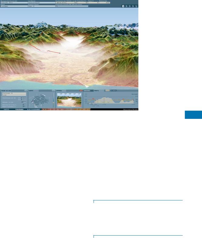
National and regional atlases depict a country or a region in a broad variety of mainly thematic maps. Today many national atlases have been converted from the printed to the interactive form. There also exist mixed versions like the National Atlas of Germany which consists of a series of theme books and accompanying CD-ROMs with the full text, the maps plus some additional interactive maps [13]. An example for an entirely digital atlas is the DVD-based Atlas of Switzerland which consists of 1,000 interactive maps derived on the ßy from digital topographic, environmental and statistical base data, combined with multimedia elements (Fig. 1) [14].
Topographic Atlases
Many national or state mapping authorities publish their topographic map series on CD-ROM or DVD. In mostca
ses, the maps are stored in raster format, but enriched with place names and vector line data for routes and trails. Many products offer the possibility of importing own data like GPS tracks or drawing map overlays. Simple analyses like measurement functions, proÞles and 3D displays are possible. Examples are e. g., the TOPO! Interactive Maps with US Geological Survey map sheets, published by National Geographic and the Swiss Map DVDs with the Swiss National Map Series. Other atlases display georeferenced satellite or aerial images.
Thematic Atlases, Statistical Atlases
Numerous atlases cover speciÞc thematic topics like geology, hydrology, climate, planning, history, etc., both in 2D and 3D (Fig. 2). Statistical atlases allow the visualization of statistical data as choropleth or diagram maps, usually

762 Multimedia Atlas Information Systems
Multimedia Atlas Information Systems, Table 4 Differences between GIS and multimedia atlas information systems (MAIS); adapted after [12]
|
GIS |
MAIS |
Target users |
Experts |
Nonexperts |
|
|
(and experts) |
Use of interface |
Complex |
Easy |
Control of |
|
|
functions and data |
By users |
By authors |
Guidance |
Minimal |
Distinct |
Flow of information |
Unstructured |
Structured |
|
|
(narrative) |
Main focus |
Handling, analysis and |
Visualization |
|
presentation of data |
of themes |
|
|
|
Data |
Raw, not integrated |
Edited, integrated |
Data model |
Primary model |
Secondary model |
Covered area |
Open |
Usually predeÞned: |
|
|
regional, national |
Computation time |
Short to long |
Short |
Purpose |
Open for any kind |
SpeciÞc purpose |
|
of data and analysis |
|
|
|
|
on the basis of administrative boundaries (e. g., the Geoclip statistical atlas web service).
Future Directions
A major focus will be the further development of geodata models and structures. Up to now, geodata have been managed and processed in relatively specialized systems
Multimedia Atlas Information Systems, Figure 1 Example of a multimedia national atlas: lithology map in the Atlas of Switzerland , combined with text and image information. © Atlas of Switzerland
like GIS. Data are enriched with graphical attributes for cartographic visualization and thematic attributes. In the future this attributation will be handled the other way round: Thematic data will be stored in standardized, distributed databases and they will additionally be annotated with spatial information, i. e., they will be georeferenced. Search engines could be equipped with a geographical search function.
SpeciÞc cartographic functions will be developed further, e. g., automatic generalization functions, rule-based display functions or analysis functions. Real-time data, for instance, will be analyzed automatically and visualized on the ßy. The integration of user-generated data will be simpliÞed and a MAIS will become a collaborative platform that can constantly be maintained and updated by the users.
Cross References
Data Analysis, Spatial
Distributed Geospatial Computing (DGC)
Exploratory Visualization
Scalable Vector Graphics (SVG)
Visualizing Constraint Data
Web Feature Service (WFS) and Web Map Service (WMS)
Recommended Reading
1.Ormeling, F.: Atlas information systems. In: Proceedings of the 17th International Cartographic Conference, Barcelona, 3Ð9 September 1995, pp. 2127Ð2133
Multiple Resolution Database |
763 |
2.Siekierska, E., Williams, D.: National atlas of Canada on the internet and schoolnet. In: Kšbben, B., Ormeling, F., Trainor, T. (eds.) Seminar on Electronic Atlases II, pp. 19Ð23. ICA Commission on National and Regional Atlases, Prague (1996)
3.Buziek, G.: Eine Konzeption der kartographischen Visualisierung. Habilitation thesis, University of Hannover (2002)
4.Ormeling, F.: Functionality of electronic school atlases. In: Kšbben, B., Ormeling, F., Trainor, T. (eds.) Seminar on Electronic Atlases II, pp. 33Ð39. ICA Commission on National and Regional Atlases, Prague (1997)
5.Borchert, A.: Multimedia atlas concepts. In: Cartwright, W., Peterson, M., Gartner, G. (eds.) Multimedia Cartography, pp. 75Ð86. Springer, Berlin Heidelberg New York (1999)
6.Cron, J.: Graphische Benutzeroberߊchen interaktiver Atlanten Ð Konzept zur Strukturierung und praktischen Umsetzung der FunktionalitŠt; mit Kriterienkatalog. Diploma thesis, Hochschule fŸr Technik und Wirtschaft, Dresden and Institute o Cartography, ETH Zurich (2006). Available via http://www.ika.ethz. ch/teaching/Diplomarbeit-Cron.pdf; http://www.ika.ethz.ch/ teaching/Diplomarbeit-Cron-Katalog.pdf
7.Siekierska, E.M., Taylor, D.R.F.: Electronic mapping and electronic atlases: new cartographic products for the information eraÑthe electronic atlas of Canada. CISM J. ACSGC 45, 11Ð21 (1991)
8.Hurni, L.: Interaktive Karteninformationssysteme Ð quo vaditis? Kartogr. Nachr. 56, 136Ð142 (2006)
9.Da Silva Ramos, C., Cartwright, W.,: Atlases from paper to digital medium. In: Stefanakis, E., Peterson, M.P., Armenakis, C., Delis, V.(eds.) Geographic HypermediaÐConcepts and Systems. Lecture Notes in Geoinformation and Cartography:, pp. 97Ð19. Springer, Berlin Heidelberg New York (2006)
10.BŠr, H.R., Sieber, R.: Towards high standard interactive atlases: the GIS and multimedia cartography approach. In: Proceed-
Multimedia Atlas Information Systems, Figure 2 Example of a 3D atlas: 3D display of evaporation data as overlay on a digital elevation model, combined with a satellite image and atmospheric effects. The user-deÞned proÞle shows both a topographic and thematic section (lower right ). © Atlas of Switzerland
M
ings of the 19th International Cartographic Conference, Ottawa, 14Ð21 August 1999, pp. 235Ð241
11.Schneider, B.: GIS Functionality in Multimedia Atlases: Spatial Analysis for Everyone. In: Proceedings of the 20th International Cartographic Conference Beijing, 6Ð10 August 2001, pp. 829Ð840
12.Schneider, B.: Integration of Analytical GIS-functions in Multimedia Atlas Information Systems. In: Proceedings of the 19th International Cartographic Congress Ottawa, 14Ð21 August 1999, pp. 243Ð250
13.Hanewinkel, C., Tzschaschel, S.: Germany in maps Ð a multipurpose toolbox In: Proceedings of the 22th International Cartographic Conference A Coru–a, 9Ð16 July 2005: CD-ROM
14.Sieber, R., Huber, S.: Atlas of Switzerland 2 Ð A highly interactive thematic national atlas. In: Cartwright, W., Peterson, M.P., Gartner, G.(eds.) Multimedia Cartography. 2nd edn., pp. 161Ð182. Springer, Berlin Heidelberg New York (2007)
Multimedia Indexing
Indexing, Hilbert R-tree, Spatial Indexing, Multimedia Indexing
Multiple Resolution Database
Abstraction of GeoDatabases

764 Multiple Target Tracking
Multiple Target Tracking
BAIK HOH, MARCO GRUTESER
Electrical and Computer Engineering/WINLAB,
Rutgers University, Piscataway, NJ, USA
Definition
The problem of associating a set of anonymous position observations with sets of prior observations to construct the traces of several moving objects or targets. More precisely, given nt position observations at time t and previous observations nt−1, nt−2, . . . , nt−m, construct a set of traces, where each trace only contains the position observations from a single moving object. In a variation of the problem the number of actual moving objects may be greater than each n since objects may disappear and emerge during the observation interval.
Main Text
Multiple hypothesis tracking is one representative algorithm proposed by Reid [2] in 1979 to solve this problem. This algorithm uses a linear Kalman model to represent the movement behavior of each object and to Þlter observation noise. The algorithm operates in three steps. First it predicts a new system state (which includes predicted positions of each object based on the prior trajectory). Then it generates hypotheses for the assignment of new samples to targets and selects the most likely hypotheses. Finally it adjusts the system state based on the Kalman equations with information from the new samples. In this process, one hypothesis is generated for each permutation of the sample set; each permutation represents one possible association of new observations to the prior targets. The algorithm then selects the hypothesis that minimizes the error between the predicted positions and actual positions across all objects.
The performance of MHT depends on the density of targets, the frequency of observations, the predictability of target movements, and the accuracy of the target movement model. Tracking performance increases with scenarios with low user density or when targets are moving on relatively straight trajectories such as cars driving on a highway. Further tracking performance improves when observations are obtained with higher frequency.
Many variations of this algorithm have been proposed to accommodate target maneuvering, insertion of new targets, and abrupt disappearance of existing targets. If objects move on well-known roadways, multi-hypothesis tracking can be improved by also considering road maps during the linking process [1].
This problem frequently arises when several simultaneously moving objects are tracked by radar. Multi-target tracking algorithms are also a useful tool to understand the privacy of anonymized positions samples in GIS applications. This approach can be viewed as an inference attack; thus, privacy is compromised if these algorithms can recover longer traces from individual samples.
Cross References
Privacy Preservation of GPS Traces
Recommended Reading
1.Civilis, A., Pakalnis, S.: Techniques for efÞcient road-network- based tracking of moving objects. IEEE Trans. Knowl. Data Eng. 17(5), 698Ð712 (2005) Senior Member-Christian S. Jensen
2.Reid, D.: An algorithm for tracking multiple targets. IEEE Trans. Autom. Control 24(6), 843Ð854 (1979)
Multiple Worlds
Smallworld Software Suite
Multiple-Image Bundle Block
Photogrammetric Methods
Multirepresentation
Modeling and Multiple Perceptions
Multi-Resolution Aggregate Tree
IOSIF LAZARIDIS, SHARAD MEHROTRA
Department of Computer Science, University of
California, Irvine, CA, USA
Synonyms
MRA-Tree; Ra*-Tree; aR-Tree
Definition
A Multi-resolution Aggregate tree (MRA-tree) is a multidimensional indexing structure whose nodes are augmented with aggregate information about the indexed subsets of data. Typically, such indices subdivide space or group data objects; nodes contain routing information for their children nodes, e. g., in the form of spatial partitions (as in

MX-Quadtree 765
quad-trees) or bounding rectangles (as in R-trees). MRAtrees store, in addition to this information, aggregate properties of the indexed entities, e. g., the SUM of their values, the MIN value, etc. Several such aggregates can be stored or alternatively, only those that are often queried.
Cross References
Aggregate Queries, Progressive Approximate
Progressive Approximate Aggregation
Main Text
MRA-trees are useful in answering aggregate queries approximately and in a progressive manner. Traditional multi-dimensional indexes help aggregate query answering by quickly gathering all relevant tuples. However, they have the limitation that each of those tuples must be handled individually. Moreover, approximate answers and answer quality guarantees cannot be easily computed. MRA-trees avoid visiting entire subsets of the data since they are summarized adequately at high-level tree index nodes and they can provide deterministic answer quality guarantees since the aggregate characteristics of the data at various levels of resolution are available throughout the tree. By exploring the tree progressively, the answer quality can improve all the way to the exact answer. They can therefore be used when the user speciÞes either a time deadline or answer quality requirement, trying to optimize the quality and running time, respectively, under these constraints.
Multiscale Databases
Modeling and Multiple Perceptions
Multi-Type Nearest Neighbor Query
Trip Planning Queries in Road Network Databases
Mutation
Geographic Dynamics, Visualization And Modeling
MX-Quadtree |
M |
|
|
Quadtree and Octree