

ppl_03_e2
.pdfID: 3658
Customer: Oleg Ostapenko E-mail: ostapenko2002@yahoo.com
Customer: Oleg Ostapenko E-mail: ostapenko2002@yahoo.com
CHAPTER 21: GLOBAL POSITIONING SYSTEMS (GPS)
Figure 21.2 The GPS Space, Control and user Segments.
Ephemeris Error.
Ephemeris errors are errors in the satellite’s calculation of position, caused by the gravitational effects of the sun, moon and planets and solar radiation.
Satellite Clock Error.
As with ephemeris, the satellite clock is checked at least every 12 hours by the control segment, and any error corrected. The satellite clock may malfunction, the satellite may stray from its path, or its transmitter may fail.
Receiver Noise Error.
All radio receivers generate internal noise which can cause errors in the measurement of the time difference.
Multi-path Reception Error.
Reflections from the ground and parts of the aircraft result in multi-path reception. These errors affect the accuracy of range measurements, and may affect position, drift and groundspeed information.
Geometric Dilution of Precision.
Geometric Dilution of Precision (GDOP) is the term for a poor cut between position lines. GDOP occurs when the satellites are relatively close to one another. Errors caused by GDOP are minimised by the geometry of the positioning of the satellites in their orbits and by the receivers selecting the four “best” satellites to determine position.
The satellite geometry which provides the most accurate position-fixing information is with one satellite directly overhead the receiver, and a further three satellites close to the horizon, spaced 120° apart.
Effect of Aircraft Manoeuvres.
Aircraft manoeuvres may result in part of the aircraft shadowing one or more of the in-use satellites.
367

Order: 6026
Customer: Oleg Ostapenko E-mail: ostapenko2002@yahoo.com
Customer: Oleg Ostapenko E-mail: ostapenko2002@yahoo.com
CHAPTER 21: GLOBAL POSITIONING SYSTEMS (GPS)
While the satellite is shadowed, the signal may be lost, resulting in degradation of accuracy. The effect of manoeuvres can be minimised by careful positioning of the aerial on the aircraft.
Terrain Shielding.
When an aircraft is at low level in a mountainous region, satellites may became masked with respect to the GPS receiver in the aircraft. This situation may cause sudden loss of GPS position fixing capability.
Interference and Jamming.
The GPS signal which arrives at the receiver is a low power signal and is susceptible to interference, either intentional or unintentional. UHF, microwave signals, and VHF RT transmissions may be sources of unintentional interference.
Intentional jamming is also a danger, though military excercises which include deliberate GPS jamming are notified through NOTAMs.
Sunspots and Solar Flares.
Solar radiation can affect GPS satellite transmissions. Sunspots and solar flares, which influence solar radiation, cannot be forecast.
Availability of GPS Service.
The NAVSTAR satellite system is the property of the United States government which may choose to adjust the availability of satellites as it wishes. The US government has undertaken to make GPS signals available for civilian use, but has the capability to reduce the accuracy of the system for military or other reasons, or to switch the system off completely.
GPS USE BY THE GENERAL AVIATION PILOT.
GPS is used by many pilots as a back-up system to more traditional navigation methods. GPS equipment will provide information that relates to aircraft:
•Speed and track over the ground.
•Wind velocity (in conjunction with an air data computer).
•Time and distance.
•Waypoint, alternate aerodrome, and destination information. However, this is only if the aeronautical database is updated regularly.
GPS equipment is very accurate and can be a valuable navigational aid, but it is important to remember that GPS systems should not be relied upon as primary navigation aid, for the reasons given earlier in this chapter. GPS should be used only as a back-up aid, supporting other means of navigation. Notice Advisories to Navstar Users (NANUs) are the means of informing GPS users of a planned degradation of the system. NANUs are available in the UK through the NOTAM system.
368

ID: 3658
Customer: Oleg Ostapenko E-mail: ostapenko2002@yahoo.com
Customer: Oleg Ostapenko E-mail: ostapenko2002@yahoo.com
CHAPTER 21: GLOBAL POSITIONING SYSTEMS (GPS)
GPS-System Familiarisation.
Before attempting to use GPS equipment in the air, pilots should learn as much as they can about the system they intend to use. In particular, pilots should ensure that they understand the following:
•Principles of GPS.
•System installation and limitations.
•Pre-flight preparation and planning.
•Cross-checking data entry.
•Use of the system in flight.
•Confirmation of accuracy.
•Database integrity.
•Possible sources of human error.
•System error and malfunctions.
Flight Planning.
The attention that a pilot needs to give to his GPS equipment, in flight, may be minimized by careful flight planning. Always plan your flight using the standard methods taught in Section One of this book. Then, having completed your flight log, you may enter the route information into your GPS receiver. Using this method you will be able to navigate visually in the approved manner, while using your GPS to confirm the accuracy of your navigation. If the GPS should fail, you will not be taken by surprise and will be able to continue the flight in the traditional way.
In-Flight Use of GPS.
You should continually bear in mind that GPS signals may become subject to degradation or complete loss, with the attendant possibility of position error. Furthermore, the risk of human error in data input and display reading is high, so great diligence must be exercised when using GPS equipment. If in IMC, or above cloud, use GPS only in combination with other radio aids with which the GPS data may be compared. If your GPS display confirms the information given by other radio aids, and by your dead reckoning calculations, you will know that the GPS is likely to be providing accurate data.
Be aware that hand held GPS equipment, running on batteries, can become discharged quickly.
Above all, you should never become totally dependent upon a GPS. Always question your GPS data and ask yourself:
•Does the information I am receiving from my GPS agree with at least one other independent and confirmed source of navigational data?
•Could I safely continue with my flight without my GPS if it were to fail completely, at this very moment?
369

Order: 6026
Customer: Oleg Ostapenko E-mail: ostapenko2002@yahoo.com
Customer: Oleg Ostapenko E-mail: ostapenko2002@yahoo.com
CHAPTER 21: GLOBAL POSITIONING SYSTEMS (GPS)
Other Potential Hazards Arising From the Use of GPS.
General Aviation reports have indicated that, with increasing use of GPS, pilots are often tracking exactly overhead features which they nominate as turning points, or other points of reference. This practice increases the risk of collision with other aircraft whose pilots are doing the same thing.
When flying towards Visual Reference Points (VRP), for instance, pilots are reminded they should not overfly the VRP, but report their position with reference to the VRP.
370

Customer: Oleg Ostapenko E-mail: ostapenko2002@yahoo.com
ANNEX A
THE FLIGHT
INFORMATION SERVICE
371
Customer: Oleg Ostapenko E-mail: ostapenko2002@yahoo.com
ANNEX A: THE FLIGHT INFORMATION SERVICE
372
Customer: Oleg Ostapenko E-mail: ostapenko2002@yahoo.com
ANNEX A: THE FLIGHT INFORMATION SERVICE
WHAT IS A FLIGHT INFORMATION SERVICE?
A Flight Information Service (FIS) is an Air Traffic Service provided by Air Traffic Service Units (ATSU) and Flight Information Region (FIR) Centres to aircraft flying outside controlled airspce for the purpose of supplying information to pilots which is useful for the safe, orderly and efficient conduct of flights.
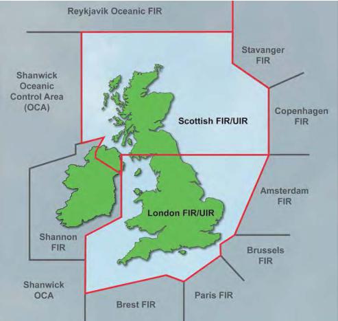
Figure Annex A.1 The lateral limits of the London and Scottish Flight Information Regions.
The FIS is probably the service most frequently used by VFR pilots who are on cross country flights in uncontrolled (Class G) airspace, sometimes known as the
Open FIR. Of course, there is no reason why a pilot should not ask for an FIS from a convenient ATSU while on a local flight.
UK FLIGHT INFORMATION SERVICE
In the UK, Air Traffic Services Outside Controlled Airspace (ATSOCAS) are provided by a variety of air traffic units and used by a wide variety of users from General Aviation to commercial flights and military aircraft.
The suite of services is collectively known as the “UK Flight Information Service”. They are detailed in CAP 774 and summarised here.
373

Customer: Oleg Ostapenko E-mail: ostapenko2002@yahoo.com
ANNEX A: THE FLIGHT INFORMATION SERVICE
It is of
supreme importance
that pilots understand that, while receiving an FIS, they are not under air traffic control and are responsible for their own collision and terrain avoidance.
Outside controlled airspace, it is not mandatory for a pilot to be in receipt of an air traffic service. This principle generates a traffic environment over which air traffic controllers have no oversight. Consequently, outside controlled airspace, it is the pilot who bears responsibility for collision avoidance and terrain/obstacle clearance.
There are 4 distinct services to the new “UK Flight Information Service”:
1. Basic Service; 2. Traffic Service; 3. Deconfliction Service;
4. Procedural Service
The various services are designed to cater for a wide variety of airspace users and tasks. It is essential that controllers and pilots all have a detailed knowledge of the services. Within an FIR, the only service that is required to be offered, as mandated by ICAO, is the Basic Service. The other three services may be provided by ATSUs if they are suitably equipped and have the capacity to do so. However, the UK Lower Airspace Radar Service (LARS) will, within their operating hours, offer the more comprehensive Traffic and Deconfliction Service which require radar surveillance equipment.
Pilot compliance is relied upon in order to promote a safer operating environment, but it is not mandatory.
Pilots should determine the most appropriate service for the phase and conditions of the flight and request that service from the controller.
You should note that a FISO will provide a Basic Service only.
Basic Service.
A Basic Service is intended to offer the pilot maximum autonomy. Avoidance of other traffic and terrain is solely the pilot’s responsibility.
The controller/FISO will pass information pertinent to the safe and efficient conduct of flight. This can include weather, changes of serviceability of facilities, conditions at aerodromes and general activity information within an air traffic service unit’s (ATSU) area of responsibility. Pilots should not expect traffic information when outside an
ATZ.
It is not necessary to have an ATS surveillance system to offer a Basic Service. It is important that pilots should know this fact. The Basic Service is, therefore, not an appropriate service for flight in IMC.
Within a Basic Service, “Agreements” between pilots and controllers (and FISOs) can be established to restrict an aircraft to a specific flight level or altitude, level band, heading, route, or operating area.
Please note that the Flight Information Service referred to by ICAO is the same as the Basic Service as provided in the UK.
Traffic Service.
A Traffic Service provides the pilot with surveillance-derived traffic information on conflicting aircraft. No deconfliction advice is passed and the pilot is responsible for collision avoidance.
374
Customer: Oleg Ostapenko E-mail: ostapenko2002@yahoo.com
ANNEX A: THE FLIGHT INFORMATION SERVICE
ATrafficServicecontainstheinformationavailableinaBasicService,andadditionally, controllers will endeavour to provide surveillance-derived traffic information on relevant traffic which is anticipated to pass within 3 nm and 3000 ft.
Deconfliction advice is not offered.
A Traffic Service is available under any flight rules or meteorological conditions. However, it is not an appropriate service for flight in IMC if another more suitable service can be offered.
Agreements can be established to restrict an aircraft to a specific level, level band, heading, route, or operating area.
A pilot may operate under his own navigation or a controller may provide headings or levels for positioning, sequencing or navigational assistance.
A pilot must not change general route, manoeuvring area, heading or levels or a controller-allocated heading without first advising and obtaining a response from the controller.
Allocated levels will be terrain safe.
Deconfliction Service.
A Deconfliction Service provides the pilot with traffic information and deconfliction advice on conflicting aircraft.
However, the avoidance of other aircraft is ultimately the pilot’s responsibility.
A Deconfliction Service contains the information available in a Basic Service, and, additionally, controllers will aim to assist the pilot with his responsibility for the safety of the aircraft by passing traffic information and deconfliction advice.
Headings and/or levels will also be issued for positioning, sequencing and/or deconfliction advice.
The pilot may decide not to act on the advice, in which case he must inform the controller and then accept responsibility for deconfliction.
A Deconfliction Service is available under any flight rules or meteorological conditions.
Controllers will expect the pilot to accept headings and/or levels that may require flight in IMC.
A Deconfliction Service is to be provided only to aircraft operating at or above the
ATC unit’s terrain safe level unless the aircraft is on departure from an aerodrome or on an instrument approach.
A pilot must not change heading or level without first advising and obtaining a response from the controller. If a heading or level allocation is unacceptable, the controller must be immediately informed.
375
Customer: Oleg Ostapenko E-mail: ostapenko2002@yahoo.com
ANNEX A: THE FLIGHT INFORMATION SERVICE
Procedural Service.
A Procedural Service is a non surveillance service during which instructions are provided which, if complied with, will achieve deconfliction minima with respect to other aircraft in receipt of a Procedural Service from the same controller.
The avoidance of other aircraft is the pilot’s responsibility.
A Procedural Service contains the information available in a Basic Service, and, additionally, controllers will aim to assist the pilot with his responsibility for the safety of the aircraft by providing vertical, lateral, longitudinal, and time instruction, aimed at achieving deconfliction from other aircraft to which the controller is also providing a Procedural Service.
A Procedural Service is available under any flight rules or meteorological conditions.
Controllers will expect the pilot to accept radial, track, level and time allocations that may require flight in IMC.
Pilots who do not require deconfliction advice should not request a Procedural
Service.
Under a Procedural Service, high reliance is placed on the pilot’s ability to follow radial, track and time allocations; therefore in high controller workload and/or where airspace availability is limited, controllers may not be able to provide a Procedural
Service to a pilot who is flying purely by visual references.
Controllers will provide deconfliction instructions by allocating levels, radials, tracks and time restrictions, or use pilot position reports, aimed at achieving planned deconfliction minima with respect to other aircraft receiving a Procedural Service.
If a radial, track, time or level allocation is unacceptable to the pilot, the controller must immediately be informed, and pilots must not change radial, track or time allocation without first advising and obtaining a response from the controller.
In a Procedural Service, controllers may specify required altitudes or flight levels.
A VFR PILOT’S RESPONSIBILITIES WHEN RECEIVING A FLIGHT INFORMATION SERVICE?
In any exchange of radio transmissions between a pilot and an ATSU, the pilot bears the general responsibility for transmitting his intentions, requests and responses succinctly, clearly and effectively to the ground operator. Professional pilots are specifically trained in radio communication techniques, but the typical private pilot, flying VFR, will not have received such training. It is, therefore, incumbent on the VFR pilot wishing to become an effective user of airspace and of air traffic control services to take responsibility for his own training and skill-development in this field.
Of one thing you may be certain: if you are to gain maximum benefit from the services that ATSUs can provide you, as a VFR pilot, the manner in which you use your radio must make it clear to theATSU operator that you are a competent and proficient pilot, navigator and radio operator.
376