

A Dictionary of Archaeology
.pdfJ
Jaffa see PHILISTINES
Jainism Religion founded in the 6th century BC by Varadahaman Mahavira, a contemporary of the Buddha and a nobleman from Vaisali (a centre of the GANGES CIVILIZATION). Mahavira travelled throughout the Ganga-Yamuna region, preaching a faith of ascetism and a denial of the existence of a supreme deity. A major ethical principle of Jain belief is ahimsa (the practice of non-injury to any living thing). Mahavira is believed to be the last of the 24 Tirthankaras or Jain saviours.
Early Jain monuments date to the MAURYAN ruler Ashoka (273–232 BC) and the faith soon spread throughout India, with Jain temples and sculptures coexisting with Buddhist, and later Hindu constructions. A major Jain site of the 9th–10th century AD is Shravana Belgola in Karnataka, South India. Numerous stone shrines flank a stairway on a granite hill surmounted by a monolithic sculpture of the naked saint Bahubali, the son of the first Tirthankara; at 17.7 m tall this is the largest freestanding sculpture in India.
V.A. Smith: The Oxford History of India, 4th edn (Delhi, 1981), 76–80; G. Michell: The Penguin guide to the monuments of India I (Harmondsworth, 1989), 24–5, 466–8.
CS
Jamestown North American historic-period site, situated beside the James River in southeastern Virginia, which was the location of the first permanent English settlement in North America. Established in AD 1607, the town was the seat of the first legislative assembly in the English colonies, and was the scene of Bacon’s Rebellion in 1676–7. Research at Jamestown has revealed much about the daily lives of colonial Virginia residents during the 17th and 18th centuries. Archaeological investigations conducted during the 1990s have focused on locating the settlement’s original stockade, which until recently, was thought to have been destroyed by flooding and erosion.
W. Kelso: Jamestown rediscovery I (Richmond, 1995); C. Orser and B. Fagan: Historical archaeology (New York,
1995), 25–6; W. Kelso: Jamestown rediscovery II (Richmond, 1996).
RJE
Japan The Japanese archipelago lies off the west coast of the Asian continent. The main islands (Hokkaido, Honshu, Shikoku and Kyushu) are located mainly in the temperate zone, but the extreme northeast is subarctic and the far southwest is subtropical. The archipelago catches the edge of the monsoon and has great regional and seasonal differences in climate and vegetation. In general, cold dry winters contrast with hot humid summers. The Japan Sea coast of Hokkaido and northern
before 130,000 BC |
|
||
30,000 |
Early |
Palaeolithic |
|
Late |
|||
10,000 |
|
||
Incipient |
|
||
7500 |
|
||
Initial |
|
||
5000 |
|
||
Early |
|
||
3500 |
Jomon |
||
Middle |
|||
2500/2000 |
|
||
Late |
|
||
1000 |
|
||
Final |
|
||
300 |
|
||
Early |
|
||
100 |
|
||
BC |
Yayoi |
||
100 |
Middle |
||
AD |
|
||
300 |
Late |
|
|
Early |
|
||
400 |
|
||
Middle |
Kofun |
||
500 |
|||
Late |
|
||
710 |
|
||
Nara period |
|
||
794 |
Early Historic |
||
Heian period |
|||
|
|
||
|
|
||
Table 13 Japan |
Chronology of Japanese prehistory. |
||

316 JAPAN
05 cm
Tsubai Otsukayama
0 |
200 km |
||
|
|
|
|
(a)
0100 m
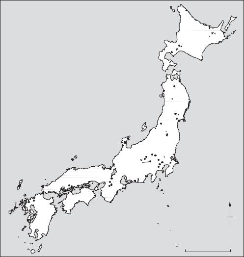
Figure 25 Japan, 4 (a) Kofunperiod bronze mirror found in the mounded tomb of Kannonyama No. 51, Hyogo prefecture, and map of mainland Japan showing the distribution of mirrors of the same type, as well as the location of Tsubai Otsukayama tomb which may well be the epicentre of the distribution, (b) contour plans of three typical examples of the characteristic ‘keyhole shaped’ tombs of the Kofun period in Japan, and map showing concentrations of keyhole-shaped tombs on the Japanese mainland. Source: A. Ono, H. Harunari and S. Oda (ed.): Zukai: Nihon no Jinrui Iseki (Tokyo University Press, 1992).
(b)
Honshu have heavy winter snows. The three predominant forest zones are, from north to south and with some altitudinal variation, coniferous, deciduous and broad-leaf evergreen, supporting diverse fauna and flora. Fish are abundant off the coasts of the archipelago, where warm and cold ocean currents meet. The islands have high interior mountains and less than 15% of the total land area of the archipelago consists of plains. Inland mountain basins and riverine terraces have attracted settlement throughout prehistory. Frequent volcanic activity and earthquakes make for an unstable
JAPAN 317
environment but recently have provided useful archaeological marker horizons.
Sections: 1 Palaeolithic; 2 Jomon period; 3 Yayoi period; 4 Kofun period; 5 Early Historic periods
1 Palaeolithic. The Japanese archipelago was joined to the Asian continent by landbridges several times during the Pleistocene and was occupied by hominids prior to 200,000 BP. The Palaeolithic is divided into two main phases, Early (pre-30,000 BP) and Late (30,000 BP–10,000 BC). More than 3000 sites are now known, following the confirmation of the existence of a Palaeolithic period in 1949,
|
|
|
|
|
Sea of |
|
|
|
|
|
|
Okhotsk |
|
|
|
|
|
|
H O K K A I D O |
|
|
|
|
|
|
Kashiwagi B |
|
|
|
|
Sugizawadai |
|
||
|
|
|
|
Babadan A |
|
|
|
|
Sea of |
|
|
Tagajo |
|
|
|
Japan |
|
|
Araya |
|
|
|
|
|
|
|
|
|
|
|
Mawaki |
|
|
|
|
|
|
Togari-ishi/ |
Kuroimine |
|
|
|
|
|
Yosukeone |
Iwajuku |
|
|
|
|
|
Kinsei |
|
||
|
|
|
|
Sakitama Inariyama |
|
|
|
|
Torihama |
Shakado Nogawa |
Sunagawa |
|
|
|
|
Shakado |
|
Otsuka and |
|
|
|
|
|
|
|
|
|
|
|
H O N S H U |
Tsubai Otsukayama |
|
Saikachido |
|
|
|
Heijo |
Toro |
|
|
|
Doigahama |
Tatetsuki Tsukumo |
Asuka |
|
|
|
|
Takamatsuzuka |
|
|
|
|||
|
|
|
|
|||
Yoshinogari |
Itazuke |
S H I K O K U |
|
|
|
N |
|
|
|
|
|||
|
|
|
|
|
|
|
Fukui Cave |
K Y U S H U |
|
|
|
|
|
|
|
|
|
|
|
|
|
|
|
|
|
PACIFIC OCEAN |
|
|
|
|
|
|
0 |
300 km |
Map 23 Japan |
Major sites in the region mentioned in the main text or with individual entries in the Dictionary. |
|||||
318 JAPAN
at IWAJUKU. Palaeolithic sites mainly consist of lithic scatters and piles of burnt cobbles within a cultural layer as at NOGAWA. The occupational histories of settlements are being extensively studied through the use of lithic refitting at sites such as SUNAGAWA in Tokyo. Most Palaeolithic artefacts in Japan are chipped stone tools which show morphological developments in tandem with the continent.
Although there is still considerable controversy over when humans first occupied Japan, sites such as BABADAN A suggest dates of at least 130,000 BP and probably considerably earlier. The earliest human remains are from Minatogawa and Mikkabe in Okinawa, and date to 18,000 BP. Early Palaeolithic technology comprised pebble tools, large flake tools and large blade flakes. The Late Palaeolithic began with the appearance of blade tools and is divided into four phases. Phase II (from 25,000 BP) was characterized by considerable regional variability of blade manufacturing techniques including the side-blow method, reflecting adaptation to locally available materials, some of which, notably obsidian and sanukite, were transported over long distances. Microlithic technology characterised Phase III, from 14,000 BP. Phase IV, synonymous with the Incipient Jomon (see below), included the earliest pottery associated with microcores (in western Japan) and with edge-polished axes and stemmed points (in eastern Japan).
2 Jomon period. At the beginning of the Holocene the landbridges which had connected Kyushu and Siberia to the continent at various times during the Pleistocene were finally submerged and Japan entered the Jomon period, during which many regional cultures of affluent foragers waxed and waned.
The six phases of the Jomon period are: Incipient (10,000–7500 BC), Initial (7500–5000 BC), Early (5000–3500 BC), Middle (3500–2500/ 2000 BC), Late (2500/2000–1000 BC) and Final (1000–300 BC). The oldest dated pottery is from the Incipient Jomon layers at FUKUI CAVE, but was associated with Late Palaeolithic lithics. The Initial Jomon was the formative stage in the Jomon tradition, while the archetypal Jomon way of life based around settled villages was established in the Early Jomon in a milieu of climatic warming and high sea-levels. Early Jomon settlements such as TORIHAMA had considerable impact on the surrounding environment, and present elaborate architecture as at SUGIZAWADAI. The Middle Jomon cultures in central Honshu represent a peak of cultural complexity seen at sites such as
SHAKADO, TOGARI-ISHI AND YOSUKEONE. Long
repeated occupations led to characteristic circular settlement plans as at Nishida. While the settlement of central Honshu suddenly declined at the end of the Middle Jomon, the appearance of large shell middens along the Pacific coast of eastern Honshu reflected the development of sophisticated fishing cultures in the Late Jomon. These continued into the Final Jomon, and resisted the advance of rice agriculture which had already appeared in Kyushu. There was widespread intensive ritual activity in the later part of the period, as at KINSEI, with the development of community cemeteries such as TSUKUMO and social differentiation as at
KASHIWAGI B.
3 Yayoi period (300 BC–AD 300). The cultivation of paddy rice began in Japan in the 1st millennium BC. Introduced from the continent, the arrival of this new subsistence strategy had a revolutionary effect on the course of Japanese prehistory and has provided the staple foodstuff of Japanese populations until the present. The spread of rice farming and associated sets of material culture derived from the continent constitute the Yayoi period (300 BC–AD 300), which is named after a location in Tokyo where Yayoi pottery was first discovered. Divided into Early, Middle and Late phases (Early: 300–100 BC, Middle: 100 BC–AD 100, and Late: AD 100–300), it was characterised by wet-rice agriculture at sites such as ITAZUKE, the use of bronze and iron, increasing social differentiation, and warfare and trade with the Asian continent.
Yayoi pottery comprises mainly utilitarian longnecked jars, wide-mouthed pots, deep basins and pedestalled bowls with simple geometric designs. Particularly in the Early Yayoi, there is considerable difference between assemblages from western Japan, where styles are close to Continental types, and eastern Japan, where there is much more continuity from Jomon styles.
Settlements such as TORO consist of small lowland communities of tightly packed pit houses with raised storehouses. They are often moated, as at YOSHINOGARI. In the Late Yayoi in some regions there was a shift to upland locations, probably for defensive purposes. Beliefs were largely related to rice agriculture and included divination. Ceremonial bronze swords and bell-shaped dotaku derived from more utilitarian Continental models. Inhumation was the main burial form, although there was considerable variation as at DOIGAHAMA. By the Late Yayoi, many small polities and some regional chiefdoms had arisen. Elite mound burials of the Late Yayoi such as TATETSUKI are ancestral to the mounded tombs of the succeeding Kofun period.
4 Kofun period (AD 300–710). By the 4th century AD the process of state formation was already underway in western Japan and by the 8th century the fully developed Ritsuryo state controlled much of the archipelago. This process dominated the Kofun period which is divided into three phases: Early (AD 250/300–400); Middle (AD 400–500) and Late (AD 500–600 in Kinai and AD 500–710 in other regions). During the Early phase, large keyholeshaped mounded tombs, such as TSUBAI OTSUKAYAMA, appeared (see figure 25). These tombs, usually surrounded by earthenware haniwa funerary sculptures, derive in part from the mounded tombs of the preceding Yayoi period such as TATETSUKI, but also reflect Chinese influences seen in qualitative differences in scale, construction and grave goods. Pottery was the unglazed earthenware called Haji ware, which derived from Yayoi ceramic tradition.
The Middle Kofun saw the introduction of the Chinese writing system (seen in inscriptions as at SAKITAMA INARIYAMA), civil engineering projects, such as irrigation canals, and large scale landclearance for agriculture, along with an increase in the importance of dry-field cultivation. These changes in land-use underlay the development of land reforms. The late 5th century AD was marked by the appearance of Sue pottery, a grey stoneware initially imported from the Korean peninsula and subsequently produced in Japan for funerary purposes.
Major social and political changes occurred in the Late Kofun. Burial in mounded tombs was no longer the preserve of chieftains, and many small round circular tombs appeared for lesser nobles and landowners. In the Kinai region the YAMATO state appeared, based at the capital at Fujiwara. Tombs such as TAKAMATSUZUKA show how the aristocracy were buried.
Throughout the Kofun period, status divisions between communities became marked within a predominantly dispersed settlement pattern. Major regional centres have been identified as at Narutaki in Wakayama Prefecture. Residences of local chiefs have been found at Mitsudera, along with commoners’ settlements as at KUROIMINE.
5 Early Historic periods (AD 710–1183). The Early Historic periods in Japan began with the arrival of Buddhism in the middle of the 6th century AD. The 7th century AD is named after the political centre at ASUKA, and witnessed the first written law codes, the first centralised government and the first Chinese-style city plan at Fujiwara. In AD 710 the capital was moved to HEIJO, near present-day Nara city. The Nara period lasted until 794 when a new
JARMO 319
capital was established at Heian-kyo in modern Kyoto. The 8th century saw the consolidation of the Ritsuryo state, and military campaigns against the Ezo and Emishi from border garrisons such as
TAGAJO.
The early chronicles, the KOJIKI and NIHON SHOKI provide many details of life in the Early Historic periods. Further written evidence has been provided by the discovery of large numbers of wooden tablets containing invaluable information about the movement of peoples and goods and the bureaucracy. Palaces, capital sites and local administrative centres have been excavated; these centres controlled the 58 provinces and three islands of the Yamato state. The provinces were further divided into 300–500 counties, which had their own administrative centres, often associated with a Buddhist temple.
T. Akazawa, S. Oda and I. Yamanaka: The Japanese Palaeolithic: a techno-typological study (Tokyo, 1980); T.E.G. Reynolds and G.L. Barnes: ‘The Japanese Palaeolithic: a review’, PPS 50 (1984), 49–61; T. Akazawa and C.M. Aikens, eds: Prehistoric hunter-gatherers in Japan
(Tokyo, 1986); R.J. Pearson et al., eds: Windows on the Japanese past: Studies in archaeology and prehistory (Ann Arbor, 1986) [pp. 397–404, Early Historic period]; K. Tsuboi, ed. Recent archaeological discoveries in Japan
(Paris and Tokyo, 1987); T.E.G. Reynolds and S.C. Kaner: ‘Japan and Korea at 18,000 BP’, The world at 18,000 BP. Volume 1, High latitudes, ed. O. Soffer and C. Gamble (London, 1989); S. Kaner: ‘The Western-language Jomon’, Hoabinhian, Jomon, Yayoi, Early Korean States: bibliographic reviews of Far Eastern Archaeology 1990, ed. G.L. Barnes (Oxford 1990), 31–62; H. Ishino: ‘Rites and rituals of the Kofun period’, JJRS 19/2–3 (1992), 191–216; R. Pearson: Ancient Japan (Washington, D.C., 1992); K. Tsuboi, ed.: Archaeological studies of Japan. Acta Asiatica 63 (Paris, 1992); D. Denoon et al., eds: Multicultural Japan: Palaeolithic to postmodern (Cambridge, 1996).
SK
Jarmo Typical small Neolithic tell-site in northern Iraq, consisting of 16 strata of occupation, 11 dating to the ACERAMIC NEOLITHIC phase. Between 1948 and 1955 the site was excavated by R.J. Braidwood, revealing square houses made of pisé, containing ovens and sunken clay basins. The characteristic artefacts include microliths as well as flint sickles, saddle querns, rubbers and mortars and pestles. These tools, along with the carbonized remains of cultivated grains and the bones of domesticated cattle, sheep and pigs, clearly indicate a highly developed agriculturally-based economy, the aceramic phase of which has been assigned by radiocarbon dating to as early as c.6750BC. The term
320 JARMO
‘Jarmoan’ is used by Braidwood et al. (1983: 13) to describe the Mesopotamian ‘early village farming community’ exemplified not only at Jarmo but also at such sites as ALI KOSH, Ganj Dareh and Tepe Guran (see LURISTAN).
R.J. Braidwood: ‘Jarmo: a village of early farmers in Iraq’, Antiquity 24 (1950), 189–95; J. Mellaart: The Neolithic of the Near East (London, 1975), 80–2; L.S. Braidwood et al., eds: Prehistoric archaeology along the Zagros flanks
(Chicago, 1983).
IS
Java The Javan sites of Trinil, Sangiran and Ngandong (Solo) provide some of the earliest evidence of hominid occupation in Asia. Found by Eugene Dubois in 1890, the Trinil beds yielded fossil teeth and cranial bones (‘Java Man’) later attributed to HOMO ERECTUS. The site is now thought to date from c.700,000 BP. The Sangiran site, discovered by von Koenigswald, produced fossil crania of a similar date. Ngandong, previously called Solo, has produced fossils of EARLY HOMO SAPIENS which resemble those from Africa (e.g. Broken Hill/Kabwe, see SANGOAN), Europe (e.g. Petralona) and also the Dali skull from Shaanxi province in China. The Ngandong fossils are said to be dated to between 200,000 and 150,000 years BP. A very early potassium-argon date of 1.8 million years has recently been proposed for the site of Mojokerto, with dates of 1.66 million years for the Sangiran material. However, the relationship between the tested materials and the fossils is very dubious.
PG-B
Jebel Mesolithic cave in southwestern Turkmenistan, in the southern fringe of the Greater Balkan ridge, the northern off-shoot of the Kopet Dag, 3 km north of the dry Uzboi valley. The cave was discovered and excavated by Okladnikov, who distinguished ten levels. Charcoal from level 4 suggests an approximate calendar date of 5100–5000 BC. Lithic materials include microliths (triangles, trapezes, segments), as well as small endscrapers and retouched blades. Faunal remains include numerous desert species (tortoise, agama, lizard), and numerous fish bones. Similar assemblages have been identified in neighbouring caves (Dam-Dam-Cheshma 1 and 2), as well as in the Kaylyu cave off the Caspian coast, south of Krasnovodsk.
A.P. Okladnikov: ‘Peshchera Djebel–pamjatnik drevnei kul’tury prikaspiiskih plemjon Turkmenii’, Trudy Yutake 7 (1955), 11–219; ––––: ‘Paleolit i mezolit Srednei Azii’,
Srednjaja Azija v epohu kamnja i bronzy, ed. V.M. Masson (Moscow and Leningrad, 1966).
PD
Jebel Barkal see GEBEL BARKAL
Jebel Irhoud Site in southern Morocco where
LEVALLOIS-MOUSTERIAN artefacts have been
found in association with early hominid remains. It consists of a ‘solution cavity’ filled with 8 m of Pleistocene deposits on the eastern side of a karstic limestone outcrop 55 km southeast of modern Safi. It was discovered in 1960, in the course of mining operations for barytes, and was investigated from 1961 onwards by Emile Ennouchi. The faunal remains that he recovered include about 30 mammalian species, some of which have Middle Pleistocene affinities, but their exact stratigraphic provenance is unknown. A small excavation was conducted by Jacques Tixier in 1967 and 1969, as a result of which 22 layers were identified, the lower ones (8–21) revealing traces of human occupation and an industry classified as a Mousterian of Levallois facies.
Five hominid fossils have been found in the cave: two adult crania (Irhoud 1 and 2), one juvenile and one adult mandible (Irhoud 3 and 5), and one juvenile humerus (Irhoud 4). Only the last specimen, excavated by Tixier in 1969, has a precise stratigraphic position, at the base of his layer 18.
Five ELECTRON SPIN RESONANCE dates have been
obtained on horse teeth from just above it, but as Jean-Jacques Hublin remarks, their very wide range (90–125 or 105–190,000 years ago, depending on the assumptions employed) seems inconsistent with the ‘close stratigraphic origin’ of the samples employed. On faunal grounds it is considered likely that the site may be up to 150,000 years old. The hominids, as at HAUA FTEAH, were at first considered to be Neanderthal, but more recently Hublin and his colleagues have thrown doubt on this interpretation. They are now considered to be archaic Homo sapiens (lacking distinctive Neanderthal apomorphies) somewhat similar to if slightly more primitive than QAFZEH and SKHUL. They are the probable forerunners of the anatomically modern hominids associated with the
ATERIAN in Morocco, as at DAR ES-SOLTANE II.
E. Ennouchi: ‘Un néandertalien: l’homme du Jebel Irhoud (Maroc)’, L’Anthropologie 66 (1962), 279–99; M.H. Day: Guide to fossil man, 3rd edn (London, 1977); J.J. Hublin, A.M. Tillier and J. Tixier: ‘L’humérus d’enfant moustérien (Homo 4) du Jebel Irhoud (Maroc) dans son contexte archéologique’, Bulletins et Mémoires de la Société
d’Anthropologie de Paris, 4 (1987), 115–42; ––––: ‘Recent human evolution in northwestern Africa’, Philosophical Transactions of the Royal Society of London, series B, 337/1280 (1992), 185–91; F. Amani and D. Geraads: ‘Le gisement moustérien du Djebel Irhoud, Maroc: précisions sur la faune et la biochronologie, et description d’un nouveau reste humain’, CRASP, série II, 31 (1993), 847–52.
PA-J
Jebel Moya Occupation site in the central Nile Basin of Sudan, the earliest phases of which date to the KHARTOUM MESOLITHIC. Purely on the basis of estimations of the rate of stratigraphic sedimentation Addison tentatively estimated the date of the initial occupation of Jebel Moya at c.1000 BC, but radiocarbon dates taken by J.D. Clark in the early 1970s suggest that the earliest occupation in Jebel Moya and the surrounding region dated to c.8000–7000 BP, while the main phase dated to c.4300 BP. The pottery from the earliest deposits at the site, decorated with ‘dotted and wavy-line’ impressed patterns, is of a similar type to that of Central Saharan cultures dating back to c.9000 BP. Caneva (1991) therefore suggests that the original settlement at Jebel Moya may have been one of the first parts of the Nile valley to come into contact with groups of pastoralists from the Central Sahara in c.8000 BP.
F. Addison: Jebel Moya (Oxford, 1949); I. Caneva: ‘Jebel Moya revisited: a settlement of the 5th millennium BC in the middle Nile Basin’, Antiquity 65 (1991), 262–8.
IS
Jebel Sahaba see QADAN
Jebel Uweinat Neolithic settlement and rockart site in southeastern Libya, first examined by Hasanein Bey (1925) and Kemal el-Din (el-Din and Breuil 1928). The Uweinat rock carvings, similar to those in the Gilf Kebir, include depictions of giraffes, elephants, ostriches, wild asses and gazelle. After Myers’ 1937–8 survey of the region, Winkler (1939) made the first serious attempt to divide the drawings into different chronological phases and to reconstruct the social systems and subsistence patterns of the artists. However, McHugh (1975) has reanalysed the results of Myers’ expedition. Whereas Winkler had argued that the engraved drawings, dealing mainly with hunting, were executed by male artists and the paintings, mainly of pastoral scenes, were by women, McHugh’s revised chronology shows that the engraved drawings simply predate the paintings, the change in subject-
JEMDET NASR 321
matter probably reflecting changes in subsistence practices as in other examples of SAHARA ROCK ART.
A.M. Hasanein Bey: The lost oases (New York, 1925), 228–9; K. el-Din and H. Breuil: ‘Les gravures rupestres du Djebel Ouenat’, Revue Scientifique 66 (1928), 105–17; H.A. Winkler: Rock drawings of southern Upper Egypt
(London, 1939); W.P. McHugh: ‘Some archaeological results of the Bagnold-Mond expedition to the Gilf Kebir and Gebel Uweinat, southern Libyan Desert’, JNES 34 (1975), 31–62.
IS
Jeitun (Jeitun-depe) Early farming site in Turkmenistan, Central Asia, located at the margin of the alluvial fan of a small stream, Kara-su, within the southern sand ridge of the Kara-Kum desert, north of Ashgabad. A series of AMS radiocarbon measurements suggest an age of c.6000 BC; this and related sites represent the earliest farming economy in Central Asia (see also ASIA 1.1).
The site at Jeitun consisted of several rectangular one-roomed houses, 20–30 sq.m each, made of clay bricks, with hearths and adjacent courtyards. Domestic einkorn wheat formed 90% of the cereals identified. Stock-breeding was as important as agriculture, with domesticated goats and sheep predominant. Hunting remained an important source of meat, gazelle and onager being the most commonly exploited wild animals. In the early period about 12% of the pottery corpus consisted of distinctive hand-made cylindrical or conic bowls decorated by simple red painted patterns on a yellow background. Several figurines of humans and animals were also found. The lithic technology is dominated by microliths reminiscent of the Caspian Mesolithic.
The largest cluster of Jeitunian sites is found in Ahala, or the central Kopet Dag oasis. Jeitunrelated sites are also found in the southern foothills of the Khorassan Mountains, in northern and eastern Iran, while an eastern cluster of sites is located in the interfluve of the Meana and Chaacha rivers.
V.M. Masson: Poselenie Djeitun (Leningrad, 1971); D.R. Harris, V.M. Masson et al.: ‘Investigating early agriculture in Central Asia: new research at Jeitun, Turkmenistan’, Antiquity 67 (1993), 324–38.
PD
Jemdet Nasr Type-site of the transitional phase between the late Uruk period and the Early Dynastic I period in southern Iraq. The Jemdet Nasr period (c.3100–2900 BC) was initially defined by a distinctive style of painted pottery (buffcoloured jars painted with red and black designs),
322 JEMDET NASR
first excavated in strata between the Uruk and Early Dynastic phases at Jemdet Nasr in 1925, as well as by the apparent proliferation of a deeply drilled style of cylinder seal.
Most other aspects of Jemdet Nasr material culture (including the majority of the pottery) are virtually indistinguishable from the preceding Uruk period (c.4300–3100 BC), and few sites have yielded sufficiently continuous stratigraphy from Uruk to Early Dynastic I to allow Jemdet Nasr material to be properly characterized. Finkbeiner and Röllig (1986) have therefore suggested that the Jemdet Nasr ware – which is relatively rare compared with other ceramics of the same period – might be better interpreted as a geographical variant of the Uruk culture rather than an indication of post-Uruk date. The balance of opinion, however, still favours the retention of a Jemdet Nasr period, on the grounds that there are other ceramics peculiar to the period (Killick in Finkbeiner and Röllig 1986), as well as a distinctive type of semipictographic CUNEIFORM tablet (Nissen 1986). Jemdet Nasr pottery was excavated not only at other sites in Mesopotamia but also at sites in Oman and along the Gulf coast (e.g. Hafit, see ARABIA, PREISLAMIC), clearly indicating a wide trading network like that of the Uruk period.
Jemdet Nasr itself, located in southern Iraq about 30 km northeast of Babylon, consists of several tells covering a total area of about 15 ha, which were first excavated by Steven Langdon and Christian Watelin in 1925–8. A substantial mud-brick structure of the Jemdet Nasr period, identified by Langdon as a temple and by Watelin as a palace, is likely to have been an administrative structure, particularly in view of the tablets inscribed with ‘Uruk III’ texts that were found inside it.
E. Mackay: Report on excavations at Jemdet Nasr, Iraq
(Chicago, 1931); H. Field and R.A. Martin: ‘Painted pottery from Jemdet Nasr’, AJA 39 (1935), 310–20; U. Finkbeiner and W. Röllig, eds: Gamdat Nasr: period or regional style? (Wiesbaden, 1986); H.J. Nissen: ‘The Archaic texts from Uruk’, WA 17 (1986), 317–34; R.J. Matthews: ‘Excavations at Jemdet Nasr, 1989’, Iraq 52 (1990), 25–40 [preliminary report on the excavations of the late 1980s].
IS
Jenne-jeno Tell located 3 km southeast of modern Jenne, between the Niger and Bani rivers, in the southwestern part of the Inland Niger Delta of Mali; excavated by Susan and Roderick McIntosh in 1977 and 1981. The mound measures 760 × 550 m and rises to a height of 8 m above the floodplain. A total of 22 radiocarbon dates were
obtained, in good stratigraphic sequence, in the range from 2160 to 550 BP, supported by three others from the adjacent tells of Hambarketolo and Kaniana. The settlement shrank prior to the abandonment of the site, which was complete by AD 1468. The exclusively Iron Age cultural sequence is used by the McIntoshes to argue against an Islamic ‘external stimulus’ model for the development of trade and urbanism in the Western Sudan, since the archaeological sequence revealed at Jenne-jeno is ‘too big, too early, too far south’ to fit (McIntosh and McIntosh 1980: II, 448). Instead they propose a model based on indigenous trade networks and the PULSE THEORY.
S.K. and R.J. McIntosh: Prehistoric investigations in the region of Jenne, Mali: a study in the development of urbanism in the Sahel (Oxford, 1980); R.J. and S.K. McIntosh: ‘The 1981 field season at Jenne-jeno: preliminary results’, NA 20 (1982), 28–32; S.K. and R.J. McIntosh: ‘Recent archaeological research and dates from West Africa’, JAH 27 (1986), 413–42.
PA-J
Jericho (Tell es-Sultan) Tell site in the Jordan valley which dates back to at least as early as the NATUFIAN period (c.11000–9300 BC), presumably deriving its early prosperity from the proximity of the Ain es-Sultan, an abundant source of water for irrigation purposes. The subsequent phases at Jericho provide a good basis for the study of the early ACERAMIC NEOLITHIC (Pre-Pottery Neolithic A), when Jericho was an unusually substantial settlement, as well as the later Aceramic Neolithic (Pre-Pottery Neolithic B), the Pottery Neolithic and the Bronze Age. The Natufian and Proto-Neolithic levels provide crucial evidence of the gradual development of agriculture, although there was poor recovery of environmental data compared with more recently investigated sites such as AIN GHAZAL. In common with the rest of the Levant, the stratigraphy indicates a gap of about 500 years between the end of the Aceramic Neolithic and the emergence of the Pottery Neolithic in the 6th millennium BC, presumably as a result of the impact of a drastic climatic change disrupting the subsistence and settlement pattern. By the Late Bronze Age the city had regained its prosperity and became an important CANAANITE city. Little evidence has survived to cast and direct light on the well-known Biblical siege of the city when it was captured from the Canaanites by Joshua and the Israelites.
E. Sellin and C. Watzinger: Jericho (Leipzig, 1913); Preliminary excavation reports by J. Garstang in LAAA 19–23 (1932–6) and by K. Kenyon in PEQ 84–92
(1952–60); K. Kenyon: Excavations at Jericho, 2 vols (London, 1960–5); J.R. Bartlett: Jericho (Cambridge, 1982).
IS
Jerusalem Situated in the ancient Judaean region of ISRAEL, Jerusalem dates back to the Early Bronze Age (c.3000 BC), when it was probably founded by an AMORITE tribe, the Jebusites, who called it the ‘Foundation of Salem’ (Salem being an Amorite deity). It was captured by the ISRAELITES under David in c.1000 BC, and the ‘City of David’ became the capital of the Israelite kingdom, and subsequently the capital of the Kingdom of Judah. In AD 70 the city was destroyed by the Roman emperor Titus as a result of a Jewish revolt, but a new city (Aelia Capitolina) was founded by Hadrian in 135. In 638 an Arab army led by Caliph Omar Ibn al-Khattab conquered the city, but it was captured by Crusaders in 1099, eventually falling to Saladin in 1187 and becoming part of the Ottoman empire in 1516.
The site of the ancient city was first excavated by Lieutenant Charles Warren in the late 1860s, although his work was dogged by political and logistical problems. Warren’s unorthodox methods involved the digging of deep shafts with long passages leading away from the foot of each, but he nevertheless produced a fairly comprehensive overview of the site. Since then, it has been excavated by a steady stream of different excavators, including Frederick Bliss and Kathleen Kenyon. The principal surviving features are a rock-cut water tunnel dating to the 8th century BC, remains of the Herodian palace and temple (c.AD 40–44), the Church of the Holy Sepulchre (built by Constantine in AD 335), the Mamluk–Ottoman city-walls and the late 7th-century Dome of the Rock (built over the site of King Solomon’s temple).
M. Avi-Yonah et al.: Jerusalem (Jerusalem, 1973); K.M. Kenyon: Digging up Jerusalem (London, 1974); J. Perrot, ed.: ‘Jerusalem: 5000 years of history’, DA (special issue, March 1992); G.J. Wightman: The walls of Jerusalem from the Canaanites to the Mamluks (Sydney, 1993).
IS
Jin see CH’IN
Jomon period (10,000–300BC) see JAPAN 2
Jorwe Type-site of the Jorwe period, a phase of the Indian Deccan Chalcolithic divided into Early Jorwe (c.1400–1000BC) and the more spatially re-
JULFAR 323
stricted Late Jorwe (c.1000–700 BC), found only in the Bhima River Valley (Dhavalikar 1988:13). Early Jorwe sites are distributed across much of modern Mahrashtra; a few, such as DAIMABAD, INAMGAON and Prakash, are about 20 ha in area, but most are comparatively small sites covering about 2–3 ha.
The site of Jorwe itself was excavated by Hasmukh Dhirajlal Sankalia and Shantaram Bhalchandra Deo in the early 1950s. Typical Jorwe ceramic ware has red or orange surface colour, sometimes painted with black geometric designs. Jorwe sites are also characterized by the presence of groundstone axes, copper tools and ornaments, and a distinctive blade and microlith industry.
H.D. Sankalia and S.B. Deo: The excavations at Nasik and Jorwe, 1950–51 (Pune, 1955); M.K. Dhavalikar: The first farmers of the Deccan (Pune, 1988).
CS
Jui-ch’ang-shih (Ruichangshi) Ancient mining complex near the city of Jui-ch’ang, Chiang-hsi, China, on the eastern slopes of T’ung-ling (‘Copper Ridge’). The earliest sector of the mines has been dated to the Middle Shang period (c.1650–1400 BC) on the basis of calibrated radiocarbon assessments clustering around 1400 BC (see T’UNG-LING MINES). These dates suggest that metallurgy not only appeared somewhat earlier in China than was previously thought but was also probably an independent discovery. The development of metallurgy in the CHUNG-YÜAN area relied on the procurement of copper from such sources as Jui- ch’ang-shih.
Yang Li-hsin: ‘Wan-nan ku-tai t’ung-k’uang ch’u-pu k’ao-ch’a yu yen-chiu’ [Preliminary researches into the ancient mines of the Wan-nan region], WWYY 3 (1988), 181–90; Hua Chüeh-ming, Liu Shih-chung, J. Head and N. Barnard: ‘The ancient mines of T’ung-ling, Jui-ch’ang, Chiang-hsi’ (in preparation).
NB
Julfar Town in the United Arab Emirates, which was the immediate predecessor of the city of Raðs alKhaimah, and the main town on the eastern side of the Arabian Gulf in the later Islamic period. It is the only site of this date to have been excavated in the area. Although Julfar is mentioned in texts of the 7th century AD, no remains earlier than the 14th century have yet been excavated. When the Portuguese dominated the Gulf in the 16th century, Julfar enjoyed great prosperity as the regional trading entrepôt, with its commercial network reflected in the quantities of Chinese, Vietnamese and Thai ceramics recovered, along
324 JULFAR
with Indian glass bangles and Iranian pottery. These ceramics were major contributors to the dating of the local ceramics which came from the nearby kilns in Wadi Haqil.
Julfar underwent a great expansion, whereby a 14th century settlement consisting of huts was replaced by large sand-brick houses arranged in a grid-like pattern of streets. Its first small sand-brick mosque was reconstructed to accommodate a growing congregation, and a series of five mosques was eventually built one above the other as the congregation expanded. Mosques are a useful register of demographics as all adult males are required to attend Friday prayers, therefore any congregational mosque can be expected to be large enough to accommodate at least the maximum adult male population. The Julfar excavation was unique in Arabian archaeology in the opportunity that it offered to trace the changing plan of a mosque on the same site over time.
Around Julfar, the landscape is very mobile with wadi gravels descending from the mountains to the
coastal fan, sandbars forming offshore, and the siltation of creeks. The process is very rapid, and geomorphological study was a major feature of the field research at the site. Although geomorphology is rarely brought to bear in ISLAMIC ARCHAEOLOGY, the unstable and evolving nature of the east Arabian coast makes it an important aspect of fieldwork in the area.
B.de Cardi and B. Doe: ‘Archaeological survey in the northern Trucial states’, East and West 21 (1971), 225–76;
J.Hansman: Julfar: an Arabian port (London, 1985); G.R.D. King: ‘Excavations of the British team at Julfar, Ras-al-Khaimah, United Arab Emirates’, PSAS 20–2 (1990–2) [interim reports on the 1989–1992 seasons];
C.Hardy-Guilbert: ‘Julfar, cité portuaire du Golfe arabopersique à la periode islamique’, Archéologie islamique 2 (1991), 162–203; T. and H. Sasaki: ‘Japanese excavations at Julfar – 1988, 1989, 1990 and 1991 seasons’, PSAS 22 (1992), 105–20; D. Kennet and G.R.D. King: ‘Jazirat alHulayla – early Julfar’, JRAS, 3rd series, 4/2 (1994), 163–212; R. Stocks: ‘Wadi Haqîl survey, November 1992’, PSAS 26 (1996), 145–63.
GK