

ppl_04_e2
.pdfID: 3658 |
|
Customer: Oleg Ostapenko E-mail: ostapenko2002@yahoo.com |
|
Customer: Oleg Ostapenko E-mail: ostapenko2002@yahoo.com |
1 3 : V IS IB IL IT |
C H A P T ER |
STABLE ATMOSPHERIC CONDITIONS AND INVERSIONS.
As you learnt earlier, a stable atmosphere inhibits the vertical movement of air, usually because of the presence of a temperature inversion. In a stable atmosphere, solid particles, generated by industrial and agricultural activities, will be trapped close to the Earth’s surface, reducing visibility.
Layers of particle-laden air are frequently seen when flying, and a clear boundary is sometimes visible at the ceiling of such obscuration. Poor visibility of this type is common in the vicinity of cities, especially in anticyclonic conditions.
Figure 13.4 Anticyclonic conditions make for a stable atmosphere which restricts the vertical movement of air, trapping solid particles in the lower layers of the atmosphere, thus reducing visibility.
Inversions are a feature of
anticyclonic
conditions. Inversions may often result in haze which can reduce visibility considerably.
FOG, MIST AND HAZE.
Fog is defined as a visibility of less than 1 000 m, with a relative humidity of 100%.
If the visibility is between 1 000 m to 5 000 m (although this upper limit does vary occasionally), and provided that the relative humidity is 95% or more, atmospheric obscuration is referred to as mist.
Figure 13.5 Table defining the various types of obscuration, by visibility and humidity content of the air.
Fog is
present when visibility is
less than
1 000 metres, and relative humidity is 100%.
177

Order: 6026
Customer: Oleg Ostapenko E-mail: ostapenko2002@yahoo.com
Customer: Oleg Ostapenko E-mail: ostapenko2002@yahoo.com
C H A P T ER 1 3 : V IS IB IL IT Y A ND F O G
Haze or smoke is reported when visibility is below 5 000 m, and when the humidity is not high enough for the obscuration to be classified as mist or fog. Haze or smoke is caused by solid particles. In haze, humidity will be less than 95%, and is frequently in the order of 50-60%.
PRECIPITATION.
All precipitation reduces visibility, but some types of precipitation cause a greater reduction of visibility than others.
Snow showers, can reduce the visibility very swiftly, to as low as 50 m. Drifting snow can reduce visibility to zero.
Figure 13.6 Snow can rapidly reduce the visibility to as low as 50 metres in heavy showers.
In rain, visibility is reduced by varying extents, depending upon the intensity of the rain. Visibility as low as 1 000 m or less can occur in heavy rain.
The table in Figure 13.7 summarises the effect on visibility of various intensities of rain.
Figure 13.7 The intensity and types of rain, and their effects on visibility.
178
ID: 3658 |
|
Customer: Oleg Ostapenko E-mail: ostapenko2002@yahoo.com |
|
Customer: Oleg Ostapenko E-mail: ostapenko2002@yahoo.com |
1 3 : V IS IB IL IT |
C H A P T ER |
FOG.
There are five main types of fog:
•Radiation fog.
•Hill fog.
•Advection fog.
•Frontal fog.
•Arctic Smoke or steam fog.
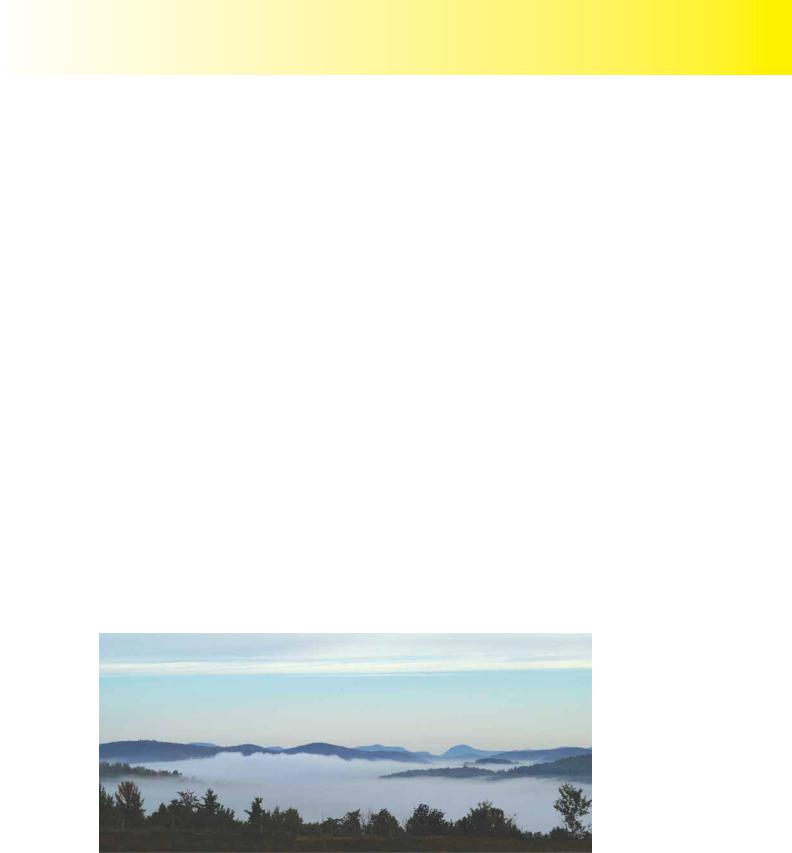
R a d i a t i o n F o g .
Radiation fog is caused by loss of heat from the Earth’s surface at night. Air in contact with the ground is cooled by conduction. If cooled to below its dew point, the water vapour in the air will condense into water droplets, and fog will form.
There are three conditions which must prevail, in order for the land to cool by the amount required for the dew point to be reached, and radiation fog to form.
•Firstly, the sky must be clear because clouds “trap” heat near the Earth’s surface.
•Secondly, there must be sufficient moisture in the air, so that cooling will result in saturation of the air overlying the cold surface. Therefore, the relative humidity of the air needs to be high.
•Thirdly, there must be a light wind of around 2-8 knots. If there is no wind, no condensation nuclei will be suspended in the air, and a dew will form on the ground instead.
Figure 13.8 Radiation Fog.
The above conditions are usually present in the atmosphere in anticyclonic conditions, especially in autumn and winter, around sunrise and sunset. When these conditions exist, radiation fog will form.
If the wind is stronger than 2-8 knots, however, mixing of the cool surface air with warmer air from levels higher up will occur, and radiation fog will not form.
179

C H A P T ER
Radiation fog will clear when
the sun warms the Earth’s
surface by insolation, and the air above the surface is then warmed by conduction which leads to convection, thus mixing the colder surface air with warmer upper air. If the wind speed increases the fog
will initially lift into low stratus.
Order: 6026
Customer: Oleg Ostapenko E-mail: ostapenko2002@yahoo.com
Customer: Oleg Ostapenko E-mail: ostapenko2002@yahoo.com
1 3 : V IS IB IL IT Y A ND F O G
Given the three conditions mentioned on the previous page, radiation fog is most common just after dawn: the time of the day when surface temperatures are at their lowest. As the Sun rises in the sky and solar radiation increases, however, the heating of the Earth’s surface will lead to the thinning and eventual dispersal of radiation fog through evaporation.
Furthermore, as the Sun warms the surface, convection becomes established in the lower layers of air, mixing the air near the surface with the warmer upper air, and dispersing the fog.
Radiation fog will be cleared, mainly from below, but also from the fog top and around the edges. Increasing wind will cause mixing and warming of the lower layers, lifting the fog into low stratus cloud.
H i l l F o g .
Hill fog forms when moist, stable air is forced to rise over high ground. The moist air will then cool and condense to create low cloud, which shrouds the high ground. This type of cloud is called orographic cloud. (From Greek oros, meaning mountain.) Orographic cloud can be localised, or extensive, and poses a major hazard to low flying aircraft. For hill walkers, orographic cloud is hill fog. Visibility in hill fog will usually be less than 200 m. The mechanism leading to the formation of orographic cloud, illustrated in Figure 13.9, has already been described in Chapter 12, in the section on the Föhn Effect.
Hill fog is the same phenomenon
as orographic cloud.
Figure 13.9 Hill fog forms when low cloud covers high ground.
Advection fog forms when
warm moist air flows over
a colder surface, which may be sea or land, and can form rapidly by day or night.
A d v e c t i o n F o g .
Advection fog can form rapidly, by day or night, when warm, moist air moves across a cold surface. The temperature of the surface must be such that the air moving over it is cooled below its dew point. For this to happen, the wind speed must be around 15 knots, and the air must have a high relative humidity. The cold surface can be either land or sea. (See Figure 13.10.)
Advection fog is common around coastlines and is sometimes called sea fog. The most common example of advection fog in the United Kingdom is that formed over the Cornish Peninsula, when the land is cold and there is a moist, warm Tropical Maritime air mass blowing over it from the south west.
180

ID: 3658 |
|
Customer: Oleg Ostapenko E-mail: ostapenko2002@yahoo.com |
|
Customer: Oleg Ostapenko E-mail: ostapenko2002@yahoo.com |
1 3 : V IS IB IL IT |
C H A P T ER |
Figure 13.10 Advection fog forms when warm moist air moves over a cold surface. Strong winds can lift advection fog to form stratus cloud.
Dispersal of advection fog usually occurs as a result of drier air moving into the area, or by an increase in wind speed, which has the effect of lifting the fog to form low stratus cloud.
F r o n t a l F o g .
Frontal fog forms just ahead of some warm, and occluded frontal systems (see Chapter 15, Air Masses and Fronts). Heavy precipitation from the warm air into the colder air, causes the colder air to reach saturation point and form fog, as shown in Figure 13.11. The belt of frontal fog can extend as much as 200 miles ahead of the front itself. The fog will clear once the front has passed.
Figure 13.11 Frontal fog: Fog occasionally forms ahead of fronts when the air ahead of the front becomes saturated. The fog will clear when the front passes.
A r c t i c S m o k e .
Arctic Smoke, or steam fog, is rare in the United Kingdom. Steam fog is created in a situation which is the reverse of that which creates advection fog. For steam fog to form, very stable, cold air moves from the land over a relatively warm, moist surface, (such as the sea, inland stretches of water or bogland). This action may cause a small amount of water vapour above the moist surface to condense, forming a shallow layer of fog.
181

Order: 6026
Customer: Oleg Ostapenko E-mail: ostapenko2002@yahoo.com
Customer: Oleg Ostapenko E-mail: ostapenko2002@yahoo.com
C H A P T ER 1 3 : V IS IB IL IT Y A ND F O G
In the United Kingdom, steam fog and arctic smoke can occasionally be seen over lakes, rivers and streams during the winter months, generally in Scotland.
Figure 13.12 Steam fog, or Arctic Smoke.
RUNWAY VISUAL RANGE.
Runway Visual Range (RVR) reports are aimed at providing pilots with accurate visibility readings along the length of a runway.
RVR reports can be found in Meteorological Aerodrome Reports (METARs), and
SPECIs (special observations to indicate a significant improvement or deterioration in weather conditions), or can be passed by Air Traffic Control to the pilot. RVR measurements are taken from an observation point along the runway itself, and so are representative of what the pilot will see on approach to the runway. RVR reports are, however, reported only when either the horizontal visibility, or the RVR itself, is less than 1 500 metres.
Figure 13.13 RVR (Runway Visual Range) is a reading of visibility along a runway, and is usually measured using a transmissometer.
RVR readings are taken every 15 or 30 minutes, depending on the amount of air traffic at an aerodrome. The instruments used to measure RVR are called transmissometers. (See Figure 13.13.) There are usually three transmissometers placed alongside the
182

ID: 3658 |
|
Customer: Oleg Ostapenko E-mail: ostapenko2002@yahoo.com |
|
Customer: Oleg Ostapenko E-mail: ostapenko2002@yahoo.com |
1 3 : V IS IB IL IT |
C H A P T ER |
runway: one at each end, and a third at the mid-point. The readings given by the transmissometers are called Instrumented Runway Visual Range readings.
If there are three transmissometer readings available for a runway, readings will generally be reported as touch-down, mid-point or stop-end readings. If there is only one figure available for a runway, it should be assumed to be the touch-down reading.
A typical RVR reading would be given as: R24L / 1100. The prefix “R” is the identifier for RVR information. The next figure is the runway designator; in this example,
Runway 24, left. The value “1100” is the touch down zone RVR visibility, in metres. As there is only one RVR value given, the value will apply to the RVR at touchdown.
RVR values of less than 50 metres are reported as M0050. An RVR greater than 1 500 metres is reported as P1500. There may also be a 10 minute trend included in the RVR report. “U” means that the visibility has increased over the last 10 minutes, “D” means that it has decreased, and “N” means that there has been no change in visibility. The letter “V” is included if there are great variations in the measured RVR. In the example: R24L / 450V600, the RVR has varied between 450 metres and 600 metres during the 10 minutes preceding the observation.
OBLIQUE VISIBILITY.
Oblique, or slant, visibility is the distance a pilot can see along the ground when flying at a given height. When flying within a haze layer, visibility will be restricted, especially when heading into sun. The area of restricted visibility is depicted by a so-called visibility hemisphere in front of the aircraft, as depicted in Figure 13.14. At the height shown at Position 1, it is not possible for the pilot to see the ground, therefore oblique visibility is said to be zero. However, if the aircraft descends to a height depicted by Position 2, the pilot would be able to see the ground, but the slant visibility would still not be good. On descending further, to Position 3, the pilot would be able to see more of the ground ahead of him.
Figure 13.14 Oblique, or slant, visibility, in haze can vary with height.
So, if a pilot is operating within a haze layer, descending should improve oblique visibility.
183

C H A P T ER
Vertical visibility
looking down through
shallow fog may be good but the slant visibility may not be good enough for a safe approach and landing, if the
aircraft descends into the fog.
Order: 6026
Customer: Oleg Ostapenko E-mail: ostapenko2002@yahoo.com
Customer: Oleg Ostapenko E-mail: ostapenko2002@yahoo.com
1 3 : V IS IB IL IT Y A ND F O G
If there is a shallow fog layer covering an aerodrome, as depicted in Figure 13.15, a pilot, looking straight down from an aircraft overhead, may be able to see the surface quite well, and might conclude that the visibility is reasonable. However, lower down, on final approach to land, when the aircraft is within the fog layer, itself, the slant visibility will be much reduced, as the pilot will now be looking through a greater thickness of fog.
Figure 13.15 When looking straight down, over a layer of fog, the surface may be visible through the fog; but on the final approach, if the aircraft descends into the fog layer, the slant visibility may not be sufficient to carry out a safe landing.
A visual illusion that the aircraft has pitched nose-up may occur on descending into shallow fog, from air where the visibility is good. This is a potentially dangerous situation, which may lead to confusion and disorientation, and is one of the main reasons that the system for determining RVR was devised.
Sixty percent of all weather-related air accidents and fatalities occur in conditions of impaired visibility.
184

ID: 3658
Customer: Oleg Ostapenko E-mail: ostapenko2002@yahoo.com
Customer: Oleg Ostapenko E-mail: ostapenko2002@yahoo.com
C H A P T ER 1 3 : V IS IB IL IT Y A ND
R e p r e s e n t a t i v e P P L - t y p e q u e s t i o n s t o t k n o w l e d g e o f V i s i b i l i t y .
1.A type of fog commonly found around coastlines, that develops rapidly both by day or night is typically:
a.advection fog
b.radiation fog
c.frontal fog
d.dense fog
2.Advection fog is often caused by:
a.a cold moist air mass under the influence of a moderate wind being warmed to below its dew point by flowing over a much warmer surface
b.a warm moist air mass under the influence of a moderate wind being cooled to below its dew point by flowing over a much colder surface
c.High relative humidity, moderate wind and a cloudy sky
d.a warm moist air mass under the influence of a very strong wind on a clear cloudless night
3.Which of the following conditions is most favourable to the formation of radiation fog?
a.High relative humidity, moderate wind and a cloudy sky
b.High relative humidity, light winds and a clear sky, just after sunrise, in autumn
c.Low relative humidity, light winds and a clear sky, just after sunrise, in summer
d.High relative humidity, light winds and a cloudy sky
4.Over an inland airfield, radiation fog is reported in the morning. As the wind speed increases to 10 knots, what would you expect?
a.The fog to thicken
b.The fog to dissipate
c.The fog to lift and form low stratus
d.An increase in mixing, allowing more fog to develop
5.In the vicinity of industrial areas, smoke is most likely to affect surface visibility when:
a.the surface wind is strong and gusty
b.cumulus clouds have developed in the afternoon
c.there is deep low pressure system over the area
d.there is a low level inversion
185

Order: 6026
Customer: Oleg Ostapenko E-mail: ostapenko2002@yahoo.com
Customer: Oleg Ostapenko E-mail: ostapenko2002@yahoo.com
C H A P T ER 1 3 : V IS IB IL IT Y A ND F O G Q U ES T IO NS
6.In unstable air, surface visibility is most likely to be restricted by:
a.haze
b.drizzle
c.showers of rain or snow
d.low stratus
7.Frontal fog is most likely to occur:
a.in summer in the early morning
b.at the rear of a warm front
c.in winter in the early morning
d.in advance of a warm front
Question |
1 |
2 |
3 |
4 |
5 |
6 |
7 |
|
|
|
|
|
|
|
|
Answer |
|
|
|
|
|
|
|
T h e a n s w e r s t o t h e s e q u e s t i o n s c a n b e
186