

ppl_04_e2
.pdfID: 3658
Customer: Oleg Ostapenko E-mail: ostapenko2002@yahoo.com
Customer: Oleg Ostapenko E-mail: ostapenko2002@yahoo.com
C H A P T ER 5 : P R ES S U R E S Y S
R e p r e s e n t a t i v e P P L - t y p e q u e s t i o n s t o t k n o w l e d g e o f P r e s s u r e S y s t e m s .
1.Which of the statements below best describes a Col?
a.An area between two highs where the isobars are very close together
b.An extension of high pressure
c.An extension of low pressure
d.An area of widely spaced isobars between two highs and two lows
2.A ridge of high pressure is generally associated with:
a.convergence at the surface, causing increased cloud and precipitation
b.atmospheric subsidence, but not so pronounced as in an anticyclone, fine-weather cumulus, and moderate to good visibility
c.tightly packed isobars, causing strong winds blowing anticlockwise around the high pressure system
d.subsidence of air, then divergence at the surface causing clear skies and poor visibility
3.An area of widely spaced isobars and light and variable winds, between two depressions and two anticyclones, is called:
a.a trough
b.a ridge
c.a col
d.a saddle
4.With an anti-cyclone predominating over the United Kingdom the expected weather would be:
a.thunderstorms in summer, fog in winter
b.stratus in summer with drizzle, cumulus and snow in winter
c.clear skies or possibly fair weather cumulus in summer, fog in winter
d.clear skies in summer with haze, and cold frontal weather in winter
5:During the winter months, which of the following weather conditions would most likely be produced by an anti-cyclone?
a.Subsidence due to surface cooling creating extensive cloud
b.During the day, the surface warming would create an unstable atmosphere with extensive cloud cover
c.During the night as the land cools, there would be an increase in the vertical cloud development
d.General subsidence producing clear skies, inversion with poor surface visibility, and heavy surface frosts
67

Order: 6026
Customer: Oleg Ostapenko E-mail: ostapenko2002@yahoo.com
Customer: Oleg Ostapenko E-mail: ostapenko2002@yahoo.com
C H A P T ER 5 : P R ES S U R E S Y S T EM S Q U ES T IO NS
6.A trough of low pressure at the surface is generally associated with:
a.surface convergence causing increased cloud and precipitation
b.surface divergence causing increased cloud and precipitation
c.subsidence causing increased cloud and precipitation
d.subsidence causing decreased cloud and precipitation
7.If a pilot flying at a given altitude in the Northern Hemisphere experiences a constant drift to the right, he will probably be flying:
a.towards the centre of an anticyclone
b.towards the centre of a depression
c.away from a low pressure area
d.within a col
8.What is the cause of high pressure at the Earth’s surface within an anticyclone?
a.lower atmosphere convergence
b.large scale ascending air
c.upper atmosphere convergence and subsidence
d.rotating winds
9.What is the cause of low pressure around a Polar Front depression?
a.the intrusion of warm air into a colder air mass along a Polar Front
b.subsidence
c.upper atmosphere convergence
d.divergence at the Earth’s surface
Question |
1 |
2 |
3 |
4 |
5 |
6 |
7 |
8 |
9 |
|
|
|
|
|
|
|
|
|
|
Answer |
|
|
|
|
|
|
|
|
|
T h e a n s w e r s t o t h e s e q u e s t i o n s c a n b e
68

Customer: Oleg Ostapenko E-mail: ostapenko2002@yahoo.com
CHAPTER 6
ALTIMETRY
69

Order: 6026
Customer: Oleg Ostapenko E-mail: ostapenko2002@yahoo.com
Customer: Oleg Ostapenko E-mail: ostapenko2002@yahoo.com
C H A P T ER 6 : A L T IM ET R Y
70

ID: 3658
Customer: Oleg Ostapenko E-mail: ostapenko2002@yahoo.com Customer: Oleg Ostapenko E-mail: ostapenko2002@yahoo.com
C H A P T ER 6 : A L T
THE ALTIMETER.
Because of the variation of air pressure with altitude, a pilot is able directly to read his aircraft’s vertical separation from the Earth’s surface, using an instrument called the altimeter.
Figure 6.1 Altimetry is based on the fundamental relationship between pressure and altitude. The altimeter is an aneroid barometer calibrated to read height.
The altimeter is a form of aneroid barometer. As you learnt in Chapter 2, any change in air pressure will cause the partially evacuated metal capsule of the aneroid barometer, to expand or contract. In the altimeter, this capsule is linked to a pointer which moves over a scale, calibrated in feet or metres, so that the pilot can read his altitude or height.
|
As an aircraft climbs, the atmospheric pressure |
|||
|
surrounding the aircraft decreases causing |
|||
|
the capsule within the altimeter to expand, |
|||
|
and the altimeter pointer to move clockwise |
|||
|
over the |
scale to indicate an increase |
||
|
in height. |
Conversely, |
when |
the aircraft |
|
descends, |
atmospheric |
pressure increases, |
|
|
compressing the capsule, causing the altimeter |
|||
|
pointer to move anticlockwise, over the scale to |
|||
|
indicate a decrease in height. |
|
||
|
Basically, then, the aircraft’s altimeter is an |
|||
|
instrument |
which measures |
atmospheric |
|
|
pressure and, in doing so, is calibrated so as |
|||
|
to indicate the vertical separation of the aircraft |
|||
Figure 6.2 A Simple Altimeter. |
from a defined pressure datum level. |
|||
It is important to note that the pressure altimeter is unable to measure vertical separation above any datum level other than a pressure datum.
We must consider, therefore, where the altimeter reading is measured from, in other words, where is the altimeter assuming the datum level to be?
The altimeter
is a form of barometer but
is calibrated in
feet (or metres) to read altitude or height.
71
Order: 6026
Customer: Oleg Ostapenko E-mail: ostapenko2002@yahoo.com
Customer: Oleg Ostapenko E-mail: ostapenko2002@yahoo.com
C H A P T ER 6 : A L T IM ET R Y
ALTIMETER SUB-SCALE SETTINGS.
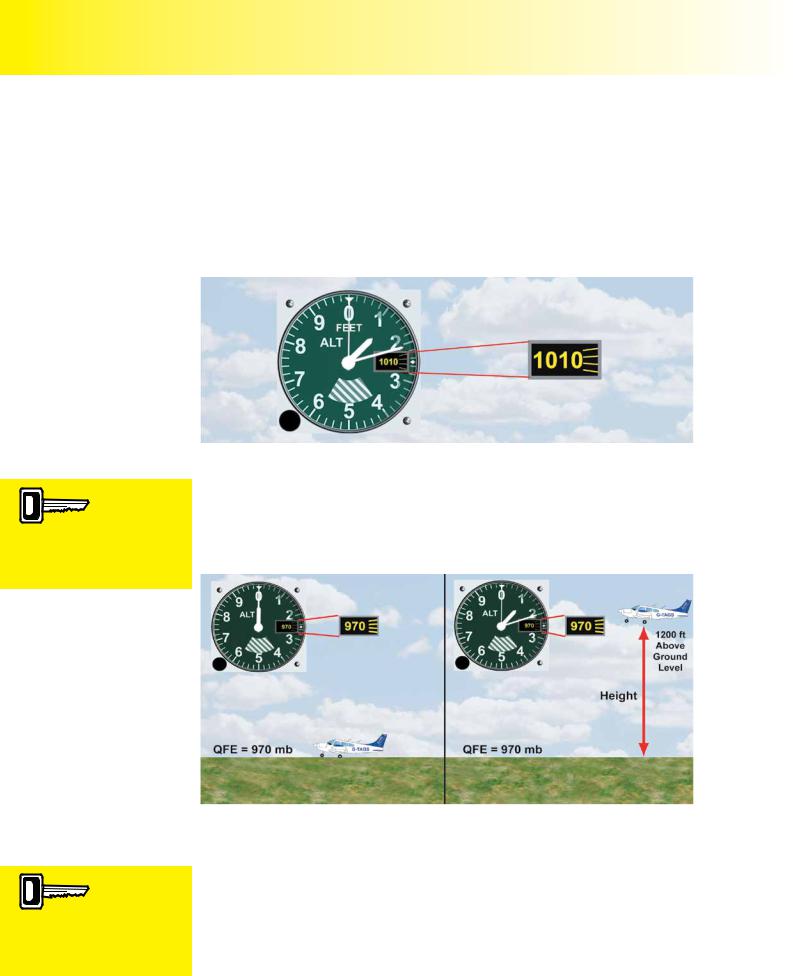
The datum with respect to which the altimeter’s scale is calibrated is neither a physical, nor geographical level; it is a pressure value. It follows, then, that the altimeter must be given a pressure value to begin measuring from, before it can indicate a vertical separation of any use to the pilot. This pressure value is selected by means of an adjustable sub-scale. The altimeter sub-scale takes the form of a small window in the face of the altimeter; which shows the selected datum pressure value, either in millibars, hectopascals or inches of mercury. (See Figure 6.3.)
The altimeter indicates
vertical separation
from a defined pressure datum level which the pilot selects in the altimeter sub-scale.
With QFE set on the sub-scale,
an aircraft’s altimeter will read zero when on the ground at the runway threshold or airfield datum.
Figure 6.3 The Altimeter Sub Scale Settings - the altimeter will read the vertical separation from the pressure datum level set on the subscale. In this case, the subscale is set to 1010 millibars (hectopascals), and the altimeter scale is in feet.
The pressure value set in the altimeter’s sub-scale window, is the pressure level that the altimeter will start measuring from; in other words, the pressure level that the altimeter will assume to be zero feet. So, if a pilot wishes the altimeter to read height above an airfield, the atmospheric pressure at the airfield must be determined and selected on the altimeter’s subscale.
Figure 6.4 QFE is the pressure at the aerodrome ground level.
With the aircraft on the ground, the pressure value at airfield level may be set on the altimeter subscale, by rotating the altimeter sub-scale setting knob until the altimeter reads zero feet.
The altimeter now has its zero datum point set at a pressure which equates to the pressure at the airfield; this pressure value is commonly referred to as the QFE. In practice, the QFE is passed to a pilot by an Air Traffic Service Unit. The QFE will be the air pressure either at the runway threshold or at some other airfield reference point. If the aircraft were then to take-off and climb, the altimeter would show the
72

ID: 3658
Customer: Oleg Ostapenko E-mail: ostapenko2002@yahoo.com Customer: Oleg Ostapenko E-mail: ostapenko2002@yahoo.com
C H A P T ER 6 : A L T
aircraft’s height above the airfield. QFE is the normal altimeter sub-scale setting for circuit flying, or operations in the immediate vicinity of the airfield.
But when flying away from the airfield, QFE is of limited use. With QFE set, the altimeter would still read the height above the departure airfield, wherever the aircraft happened to be; so unless the terrain of the region were perfectly flat, the altimeter would no longer indicate the aircraft’s height above the ground. QFE, then, gives the pilot no useful information on separation from terrain when flying cross-country.
Consequently, an alternative datum for altimeter settings is required.
When
airborne, with QFE on the
altimeter sub-
scale, an altimeter will indicate the aircraft’s height above airfield level.
When on a cross country flight, it is practical to set the altimeter to read vertical distance above sea-level.
Elevation figures given for terrain, and obstacles, on aeronautical charts, are given in feet above sea-level. So, if the altimeter is set to indicate vertical distance above sea-level, the task of maintaining safe separation from the terrain becomes much simpler for the pilot; he simply subtracts the elevation of the terrain over which he is flying from his altitude above sea-level to obtain his vertical separation from the ground beneath him.
Figure 6.5 Elevation figure for Shobdon Aerodrome: 317 feet.
Obviously, if the altimeter is to indicate vertical distance above mean sea-level, the atmospheric pressure at mean sea-level must be determined. One way of achieving this is to set the airfield’s elevation on the altimeter before take-off. The elevation of the departure airfield can be taken from an aeronautical chart (see Figure 6.5), or from another information source such as Pooley’s Flight Guide. When the pilot rotates the altimeter’s sub-scale setting knob until the altimeter’s needle points to the airfield elevation figure on the dial, the altimeter subscale window will then show the atmospheric pressure at mean sea-level.
This pressure setting on the subscale is called the QNH. With QNH set on the altimeter subscale, the indication on the altimeter is referred to as “altitude”. Altitude is defined as vertical distance of a movable object, e.g. aircraft, above mean sealevel.
Figure 6.6 With QNH set on the sub scale, the altimeter will indicate ALTITUDE above sealevel, when the aircraft is in the air, and airfield elevation when the aircraft is on the ground.
With an
aircraft on the ground and
QNH set on
the altimeter subscale, the altimeter will read the elevation of the airfield.
The altimeter
of an aircraft, in flight, with
QNH set on
the sub-scale, will indicate the aircraft’s altitude. Altitude is defined as vertical distance of a movable object, e.g. aircraft, above mean sea-level.
73

Order: 6026
Customer: Oleg Ostapenko E-mail: ostapenko2002@yahoo.com
Customer: Oleg Ostapenko E-mail: ostapenko2002@yahoo.com
C H A P T ER 6 : A L T IM ET R Y
Figure 6.6 shows an aircraft, in flight, with the altimeter indicating 1 450 feet above mean sea-level (AMSL), with a QNH of 985 millibars set on its sub-scale. The altimeter of the same aircraft, when on the ground, reads 300 feetAMSL, the airfields elevation.
In practice, QNH is determined by Air Traffic Control using a special barometer such as the one shown in Figure 2.5 of Chapter 2.
HORIZONTAL PRESSURE VARIATION.
As explained in Chapter 5, atmospheric pressure varies horizontally as well as vertically. This phenomenon can lead to problems for the pilot, because the atmospheric pressure at any given level in the atmosphere will rarely remain constant.
So if a pilot flies at a constant indicated altitude, his true altitude will usually vary over time and distance.
If an aircraft flies from high
pressure to low pressure
while maintaining the same sub-scale setting, the altimeter will over-read. At a constant indicated altitude, the aircraft will be descending.
Figure 6.7 If the pressure is the same at the departure airfield and at the destination, constant indicated altitude will give the pilot a constant true altitude.
However, if, as in Figure 6.7, the atmospheric pressure at both departure and destination airfields were to be the same, the lines of equal pressure, or isobars, at all levels between the two airfields would be horizontal. In these circumstances, as the aircraft flew along the route between the airfields, the indicated altitude, and the true altitude above sea-level would be the same.
Figure 6.8 When flying from high pressure to low pressure, true altitude will be less than indicated altitude.
74

ID: 3658
Customer: Oleg Ostapenko E-mail: ostapenko2002@yahoo.com Customer: Oleg Ostapenko E-mail: ostapenko2002@yahoo.com
C H A P T ER 6 : A L T
In Figure 6.8, atmospheric pressure at the destination airfield is lower than at the departure airfield. Notice that, now, the isobars slope downwards. Consequently, by flying at a constant indicated altitude, say at 3 000 feet, the aircraft would be following the pressure datum which causes the altimeter to read 3 000 feet. In reality, therefore, the aircraft would be descending.
So, when flying from a high pressure area to an area of lower pressure, true altitude is reducing whilst the indicated altitude remains the same. You will doubtless realise immediately that this is a potentially hazardous situation. There is, however, a saying to help you remember this fact. “From High to Low, Look out Below.” Another way to remember this is to use “Hi-lo-hi, from high to low, altimeter reads high.”
In Figure 6.9, the situation is reversed, the QNH at the destination airfield being higher than at the departure airfield. The isobars, therefore, now slope upwards. So, if an aircraft were to fly from the departure airfield to the destination airfield, while maintaining a constant indicated altitude, the aircraft would climb, following the upwards-sloping pressure surfaces. This time true altitude is increasing, while the indicated altitude remains constant. This situation is not as dangerous as the former, since the aircraft’s true altitude is increasing, but, nevertheless, the altitude indication is not accurate, so the altimeter subscale setting would not be suitable for landing. In this case we can use “Low-hi-low, from low to high, the altimeter reads low.”
Figure 6.9 Flying from low pressure to high pressure, true altitude will be greater than indicated altitude.
The above examples illustrate why pilots need to adjust the pressure setting on the altimeter subscale in order to take into account horizontal variation in pressure. Resetting the altimeter subscale, when required, is, therefore, a vital part of aircraft operations. When taking off or landing at an airfield with an Air Traffic Control Unit, the controller will normally give the pilot the airfield QNH, which must be read back to confirm that it has been received correctly. The pilot must then set QNH on the altimeter’s subscale. This essential practice ensures that the altimeter is not only reading correctly, but is reading the same as the altimeters in other aircraft, operating in the vicinity of the aerodrome.
The procedure of setting airfield QNH gives an appropriate altimeter subscale setting for departure or arrival at an airfield, or operating in its vicinity. A different pressure setting will be required as the aircraft progresses en-route.
The Regional
Pressure Setting is
the lowest
forecast pressure in a defined altimeter setting region.
75

Order: 6026
Customer: Oleg Ostapenko E-mail: ostapenko2002@yahoo.com
Customer: Oleg Ostapenko E-mail: ostapenko2002@yahoo.com
C H A P T ER 6 : A L T IM ET R Y
R e g i o n a l P r e s s u r e S e t t i n g s .
With an airfield QNH set on the altimeter, its indications may be inaccurate when the aircraft is flying cross-country at considerable distances from the departure aerodrome. In the United Kingdom, this problem is solved by the provision of Regional Pressure Settings. Regional Pressure Settings (RPS) may be obtained from any Air Traffic Service Unit providing a Flight Information Service.
Figure 6.10 Altimeter Setting Regions. Each of these regions will have its own Regional
Pressure Setting
76