

ppl_04_e2
.pdfID: 3658
Customer: Oleg Ostapenko E-mail: ostapenko2002@yahoo.com
Customer: Oleg Ostapenko E-mail: ostapenko2002@yahoo.com
C H A P T ER 1 1 : T H U NDE
INTRODUCTION.
This chapter deals with the formation of thunderstorms, and the hazards they pose to pilots.
Well-developed cumulonimbus clouds produce thunderstorms. However, in order for the cumulonimbus to reach the state of development necessary for thunderstorms to occur, certain meteorological criteria must be met. These are:
•The atmosphere must be unstable. The Environmental Lapse Rate (ELR) must be greater than the Saturated Adiabatic Lapse Rate (SALR), and that condition must extend to well above the 0ºC level.
•The air must hold sufficient water vapour to form, and sustain, the cumulonimbus cloud.
•A trigger mechanism must be present in order to produce the initial uplift of air.
The conditions
required for the
formation of
a thunderstorm cell are an unstable atmosphere, a plentiful supply of moisture and a triggering action.
TRIGGER MECHANISMS.
There are a number of trigger mechanisms within the atmosphere and on the Earth’s surface, which will cause air to ascend and, under the conditions mentioned above, begin the vigorous convective activity, required to form cumulonimbus cloud.
•Unequal surface heating is a trigger mechanism. As the surface of the Earth heats up unequally, air lying in contact with the warmer surfaces will begin to rise. This is called convection. Convection is one of the main triggers for thunderstorms, especially over land in summer.
Figure 11.1a Convection.
•In mountainous areas, the trigger for thunderstorms can be the forced ascent of air as it flows up the windward side of mountains and hills. This is called orographic uplift. (See Figure 11.1b.)
•If two air masses move together, air will be forced to rise through convergence.
(See Figure 11.1c.)
•Air is also forced to rise by frontal uplift. Cumulonimbus thunder clouds are commonly associated with the vigorous uplift of air in advance of a cold front. But, very rarely, cumulonimbus may also be embedded in warm-front stratiform cloud, too.
147

Order: 6026
Customer: Oleg Ostapenko E-mail: ostapenko2002@yahoo.com
Customer: Oleg Ostapenko E-mail: ostapenko2002@yahoo.com
C H A P T ER 1 1 : T H U NDER S T O R M S
Figure 11.1b Orographic uplift in an unstable atmosphere may trigger a thunderstorm.
Figure 11.1c Convergence in an unstable atmosphere may trigger a thunderstorm.
In frontal thunderstorms,
cumulonimbus are often
embedded in the stratiform clouds found on fronts. Embedded cumulonimbus pose a great hazard to aviation because they are difficult to see.
Figure 11.1d Thunderstorms may form ahead of a cold front.
148
ID: 3658
Customer: Oleg Ostapenko E-mail: ostapenko2002@yahoo.com
Customer: Oleg Ostapenko E-mail: ostapenko2002@yahoo.com
C H A P T ER 1 1 : T H U NDE
THUNDERSTORM CLASSIFICATION.
There are generally two different types of thunderstorms: those which occur in a single air mass, called heat-type thunderstorms or air mass thunderstorms, and those which are associated with frontal action, called frontal thunderstorms.
In the summer months, thunderstorms can be caused by convection, convergence, or orographic uplift in an unstable atmosphere. This heat-type of thunderstorm is most frequent over land, and generally forms by day. Although mainly isolated, heattype thunderstorms may, on occasion, form into lines or large groups.
Thunderstorms also occur at cold fronts, or very occasionally, at occlusions. On such occasions, they are often embedded in layered cloud, which makes them particularly hazardous to aircraft. Frontal thunderstorms form mainly over the land, and are more common in winter months. Figure 11.1d depicts the way in which a frontal thunderstorm is formed. The triggering action for a frontal thunderstorm is the lifting of the warm air by the advancing cold air.
Heat type
thunderstorms are triggered
by convection, convergence or orographic uplift in an unstable
atmosphere, and are generally isolated, although it is not unknown for lines of such storms to form lines or groups. Heat type thunderstorms normally occur in the summer.
THE STAGES OF DEVELOPMENT OF THUNDERSTORMS.
There are three main stages in the development of a thunderstorm: the initial or cumulus stage, the mature, cumulonimbus stage and the dissipating stage.
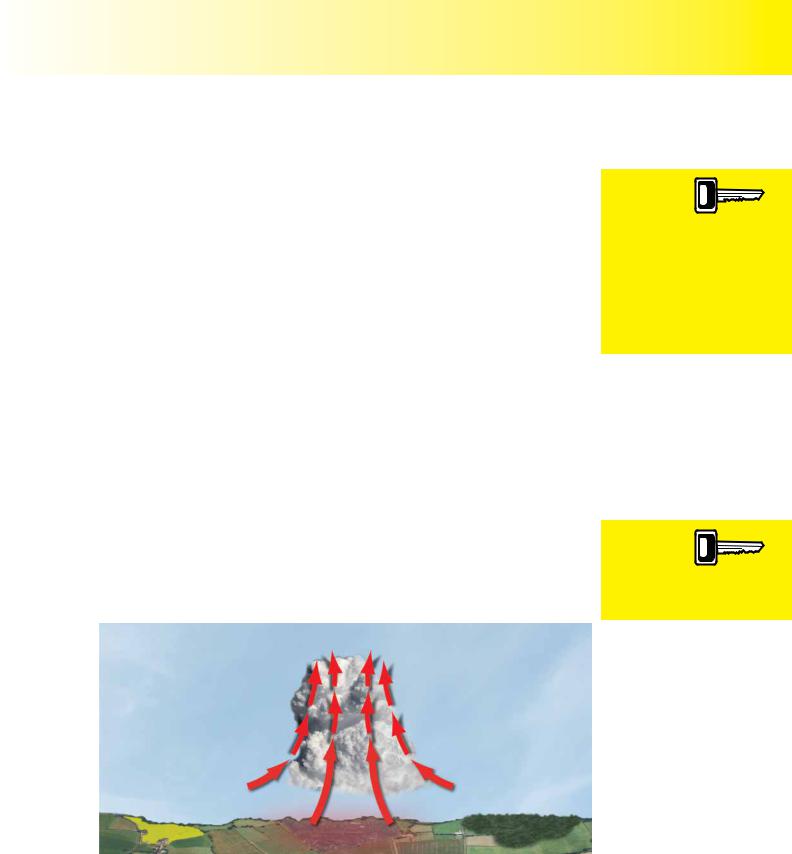
T h e In i t i a l S t a g e .
The initial stage, depicted in Figure 11.2, is characterised by strong updraughts and by the rapid growth, both horizontally and vertically, of a cumulus cloud. Strong updraughts produce clouds of great vertical extent, as air is drawn into the cloud from beneath and from the sides. This initial stage usually lasts for around 20 minutes can produce a cloud up to 5 nm across and 25 000 ft high. The rapidly developing cumulus is often called cumulus congestus or towering cumulus.
The initial
stage of a thunderstorm is characterised
by strong updraughts and rapid vertical cloud growth.
Figure 11.2 The initial stage of a thunder cloud characterised by strong upcurrents. These clouds are sometimes referred to as cumulus congestus.
149

Order: 6026
Customer: Oleg Ostapenko E-mail: ostapenko2002@yahoo.com
Customer: Oleg Ostapenko E-mail: ostapenko2002@yahoo.com
C H A P T ER 1 1 : T H U NDER S T O R M S
The mature stage of
thunderstorm development
is characterised by up and downdraughts, and the onset of precipitation.
T h e M a t u r e S t a g e .
The mature stage, depicted in Figure 11.3, is characterised by strong up and down draughts, within what has become a cumulonimbus cloud, which are accompanied by precipitation in the form of rain or hail. Downdraughts can attain 2 000 fpm or more, bringing cold heavy air down to lower levels within, and below, the cloud. These downdraughts are frequently colder than the surrounding air beneath the cloud, causing the air to sink at an even faster rate. They thus present a major hazard to aircraft caught beneath the cloud.
Figure 11.3 The mature stage of a cumulonimbus thunder cloud is characterised by strong up and down draughts, and is accompanied by precipitation.
The upcurrents within a mature cumulonimbus can attain 10 000 feet per minute, while the cloud top may grow upwards by as much as 5 000 feet per minute. In the later part of the mature stage, the cumulonimbus may begin to develop the characteristic fibrous anvil top, thought this is not always the case. Sometimes the characteristic anvil may not be seen until the cumulonimbus has begun to decay.
(See Figure 11.7.)
The rising and falling particles of rain, hail and snow cause a build up of static electricity within the cumulonimbus. The top of the cumulonimbus becomes positively charged while the lower part negatively charged. The negative charge at the base of the cumulonimbus induces a net positive charge on the Earth’s surface beneath the cloud base.
Figure 11.4 The difference in electrostatic charge between the bottom of the cloud and the surface is the cause of lightning.
150

ID: 3658
Customer: Oleg Ostapenko E-mail: ostapenko2002@yahoo.com
Customer: Oleg Ostapenko E-mail: ostapenko2002@yahoo.com
C H A P T ER 1 1 : T H U NDE
The difference in charge between the base of the cumulonimbus and the Earth’s surface eventually leads to lightning discharge, and the characteristic boom of explosively heated air, which we call thunder.
Figure 11.5 Microbursts, gust fronts and roll cloud are further hazards created by thunderstorms.
Microbursts and gust fronts, depicted in Figure 11.5, are other features of the mature stage of the cumulonimbus thunder cloud.
Microbursts are created when strong, cold downdraughts, beneath the cloud, spread out as they reach the surface. Microbursts can be very dangerous, because the rate of sink of the air may exceed the climb performance of aircraft, thereby forcing them to the ground.
In the
mature stage differences in
electrostatic
charge at the bottom of the cloud and the surface create lightning while the severe downdraughts create microbursts, gust fronts and roll cloud.
Figure 11.6 Virga.
A good visual clue to microburst activity is the presence of virga. Virga is precipitation which is falling, but not reaching the ground, and looks like tendrils hanging beneath the cloud.
As indicated in Figure 11.5, the leading edge of this out-flowing colder air beneath a mature thunder cloud is known as a gust front. The gust front marks a rapid change in wind direction and speed, and is accompanied by a noticeable temperature drop. Gust fronts are often made visible as the colder air undercuts the warm air, forcing it to rise to create cloud known as roll, or shelf clouds.
151

Order: 6026
Customer: Oleg Ostapenko E-mail: ostapenko2002@yahoo.com
Customer: Oleg Ostapenko E-mail: ostapenko2002@yahoo.com
C H A P T ER 1 1 : T H U NDER S T O R M S
Once developed, cumulonimbus clouds and the associated thunderstorms move in the same direction as the winds at around 10 000 ft. However, the horizontal development of a maturing cumulonimbus can easily extend upwind.
T h e Di s s i p a t i n g S t a g e .
The dissipating stage of a cumulonimbus thunder cloud, shown in Figure 11.7, begins as the anvil top becomes fully formed. The dissipating stage is characterised predominately by downdraughts. However, updraughts may still prevail at the summit of the cumulonimbus, feeding the growing anvil. Precipitation at this stage is usually heavy, but more widespread and less intense than at the mature stage.
The hazards to aviation
created by thunderstorms
are turbulence, windshear, icing, microbursts, hail, and lightning. Most of these hazards can be encountered in the vicinity of the cumulonimbus as well as within the cloud, itself.
Figure 11.7 The dissipating stage of the cumulonimbus thunder cloud is characterised by the thundercloud’s anvil top, downdraughts and continuing precipitation.
The dissipating stage may last for between 1½ and 2½ hours, during which time, lightning and thunder may continue to occur.
Isolated thunderstorms, although on occasions quite large, do not last long, because the severe downdraughts which accompany the precipitation suppress the upcurrents necessary to sustain the cloud. Isolated thunderstorms, then, effectively begin to dissipate once precipitation commences.
THUNDERSTORM HAZARDS.
T u r b u l e n c e .
Severe turbulence can occur in, and around, any cumulonimbus clouds, and particularly around thunderstorms. The violent up and downdraughts within cumulonimbus are especially hazardous. The downdraughts, and associated windshear which accompany microbursts, are particularly dangerous during take-off and landing, because, at those times, aircraft are in a configuration of high drag and low forward speed. Wind shear can reduce airspeed to stalling speed as well as lead to loss of control by the pilot. In extreme turbulence, structural damage and even structural failure may be suffered by airframes.
Ic i n g .
Severe icing may occur in cumulonimbus at temperatures between 0ºC and -45ºC. High concentrations of large, supercooled water droplets can lead to severe, clear icing accumulating on the airframe very quickly. Pilots should avoid icing conditions by remaining clear of cloud above the freezing level.
152

ID: 3658
Customer: Oleg Ostapenko E-mail: ostapenko2002@yahoo.com
Customer: Oleg Ostapenko E-mail: ostapenko2002@yahoo.com
C H A P T ER 1 1 : T H U NDE
Carburettor and engine icing can occur at temperatures between - 10ºC and + 30ºC, in the high humidity associated with any cloud.
H a i l .
Hail may be encountered at any height in, and underneath, a thunderstorm. Hail can also be experienced beneath the anvil of a cumulonimbus, outside the cloud. Severe damage to the skin of an airframe may be caused by hail.
L i g h t n i n g .
Lightning is most likely to occur 5 000 ft either side of the freezing level, in a part of the cloud that usually has a temperature between - 10ºC and + 20ºC. Lightning within the vicinity of an aircraft can cause the following effects:
•Temporary blindness.
•Erroneous compass reading.
•The ADF becoming unreliable, often pointing in the direction of the storm itself.
•Skin damage to an aircraft struck by lightning, especially composite aircraft.
•Ignition of the fuel vapour if the fuel tanks are nearly empty.
P r e s s u r e V a r i a t i o n s .
Large and rapid pressure variations can occur in, and around cumulonimbus, which may lead to errors in indicated altitude of up to plus or minus 1 000 feet.
Inaccurate height indications and severe downdraughts can potentially create very dangerous conditions. If the altimeter is fluctuating, a pilot should not try to maintain level flight, because there is a danger of overstressing the aircraft. It is more important to maintain attitude rather than altitude inside the storm.
GUIDANCE FOR THE AVOIDANCE OF HAZARDS.
Light aircraft should avoid thunderstorms by at least 10 nautical miles horizontally and 5 000 ft vertically.
Thorough pre-flight planning is particularly crucial before flying in weather where strong convection is expected. Low Level Significant Weather Charts (see Chapter
19), and Terminal Aerodrome Forecasts (TAFS) (see Chapter 17), should give a good indication of the timing and location of cumulonimbus and/or thunderstorm development.
Thunderstorms pose a significant danger to the safety of aircraft and it is a frightening experience for a pilot and passengers to be caught in one. Cumulonimbus clouds must be treated with extreme caution and, before a flight, the pilot should analyse weather reports and forecasts carefully, to ensure he is able to avoid cumulonimbus during the planned flight.
Light aircraft
should avoid thunderstorms
by 10 nm
because most of the hazards associated with thunderstorms can be encountered outside the cloud itself.
153

Order: 6026
Customer: Oleg Ostapenko E-mail: ostapenko2002@yahoo.com
Customer: Oleg Ostapenko E-mail: ostapenko2002@yahoo.com
C H A P T ER 1 1 : T H U NDER S T O R M S Q U ES T IO NS
R |
e p r e s |
e |
n t a |
k |
n o w l e |
d |
g e |
t i v e P P L - t y p e o f T h u n d e r s t o r m
q u e s t i o n s .
1.Thunderstorm activity is most likely to be associated with which of the following:
a.A ridge of high pressure
b.Stable anticyclonic conditions
c.The presence of mountain wave
d.A cold front
2.Which of the following combinations of weather-producing variables would be most likely to result in the formation of cumulonimbus cloud?
a.Stable moist air combined with the Föhn effect
b.Unstable air and no lifting mechanism
c.Stable dry air and orographic uplifting
d.Unstable moist air and orographic uplifting
3.For cumulonimbus clouds to develop, which of the following atmospheric conditions must be present?
a.A deep layer of stable moist air
b.A shallow layer of stable moist air at the Earth’s surface
c.A deep layer of very unstable moist air with an appropriate trigger mechanism
d.A conditionally stable dry air
4.What stage of a thunderstorm is characterised mainly by downdraughts?
a.Initial stage
b.Dissipating stage
c.Mature stage
d.Cumulus stage
5.What stage of a cumulonimbus is most likely to be characterised by a fibrous anvil shape at the cloud’s summit?
a.Dissipating stage
b.Initial stage
c.Mature Stage
d.Cumulus stage
6.Hazards of the mature stage of a thunderstorm cell include lightning, turbulence and:
a.a decreasing intensity of precipitation
b.icing, micro-burst and wind-shear
c.icing, drizzle and micro-burst
d.wind-shear, hail and fog
154

ID: 3658
Customer: Oleg Ostapenko E-mail: ostapenko2002@yahoo.com
Customer: Oleg Ostapenko E-mail: ostapenko2002@yahoo.com
C H A P T ER 1 1 : T H U NDER S T O R
7.Which of the following are most likely to produce thunderstorms?
a.A high moisture content with the ELR greater than the SALR
b.A high moisture content with the ELR less than the SALR
c.A low moisture content with the ELR less than the SALR
d.A low moisture content with the DALR greater than the SALR
8.What stage of a thunderstorm is characterised by updraughts only?
a.Mature stage
b.Initial stage
c.Dissipating stage
d.End stage
9.The atmospheric conditions which must exist to allow a thunderstorm to develop are:
a.a trigger action, a plentiful supply of moisture and a very stable atmosphere
b.a steep lapse rate and a stable atmosphere through a large vertical extent
c.a high moisture content with the ELR greater than the SALR through a large vertical extent of the atmosphere, together with a trigger action
d.a steep lapse rate through a large vertical extent, a low relative humidity and a trigger action
10.Hazards to an aircraft caused by the presence of cumulonimbus thundercloud may be experienced:
a.only when the aircraft is within the cloud
b.only when the aircraft is within or beneath the cloud
c.when the aircraft is within 10 nm of the cloud
d.when the aircraft is within 5 nm of the cloud
Question |
1 |
2 |
3 |
4 |
5 |
6 |
7 |
8 |
9 |
10 |
|
|
|
|
|
|
|
|
|
|
|
Answer |
|
|
|
|
|
|
|
|
|
|
T h e a n s w e r s t o t h e s e q u e s t i o n s c a n b e f o u n d
155
Customer: Oleg Ostapenko E-mail: ostapenko2002@yahoo.com
156