

- •Section 1: System Overview
- •1.1 PFD/MFD Controls
- •1.2 PFD Softkeys
- •1.3 MFD Softkeys
- •1.4 MFD Page Groups
- •1.5 Vertical Navigation
- •1.6 Backlighting
- •1.7 Database Updates
- •Jeppesen Aviation Database
- •Garmin Databases
- •Section 2: Flight Instruments
- •2.1 Airspeed Indicator
- •Speed Indication
- •Speed Ranges
- •Airspeed Trend Vector
- •Vspeed References
- •2.2 Attitude Indicator
- •2.3 Altimeter
- •Selected Altitude Bug
- •Altitude Trend Vector
- •Barometric Setting Box
- •Altitude Alerting
- •Metric Display
- •Low Altitude Annunciation
- •2.5 Marker Beacon Annunciations
- •2.6 Vertical Speed Indicator
- •2.7 Barometric Altitude Minimums
- •2.8 Horizontal Situation Indicator (HSI)
- •Course Pointer
- •Course Deviation Indicator (CDI)
- •Bearing Pointers and Information Windows
- •DME (optional)
- •Navigation Source
- •2.9 Wind Data
- •2.10 Generic Timer
- •3.1 Engine Display
- •3.2 Lean Display
- •Normally-aspirated Aircraft
- •Turbocharged Aircraft
- •3.3 System Display
- •4.1 Radio Status Indications
- •4.2 Volume
- •4.3 Automatic Squelch
- •4.4 Quickly Activating 121.500 MHz
- •4.5 Optional NAV Radios
- •DME Radio (optional)
- •ADF Radio (optional)
- •Auto-tuning on the PFD
- •Auto-tuning on the MFD
- •4.7 Transponder
- •Mode Selection
- •Reply Status
- •Code Selection
- •Flight ID Reporting
- •Section 5: Audio Panel
- •5.1 COM Radio Selection
- •5.2 Cabin Speaker
- •5.3 Passenger Address (PA) System (T)182T and (T)206H Only
- •5.4 Marker Beacon Receiver
- •Marker Beacon Signal Sensitivity
- •5.5 Nav Radio Audio Selection
- •5.6 Intercom System (ICS) Isolation
- •5.7 Intercom Squelch Control
- •5.8 Digital Clearance Recorder and Player
- •6.1 AFCS Controls
- •6.2 Flight Director Operation
- •Activating the Flight Director
- •Command Bars
- •AFCS Status Box
- •6.3 Flight Director Modes
- •Pitch Modes
- •Roll Modes
- •6.4 Autopilot Operation
- •Flight Control
- •Engaging the Autopilot
- •Control Wheel Steering
- •Disengaging the Autopilot
- •6.5 Example Procedures
- •Departure
- •Intercepting a VOR Radial
- •Flying a Flight Plan/GPS Course
- •Descent
- •Approach
- •Go Around/Missed Approach
- •6.6 AFCS Annunciations and Alerts
- •AFCS Status Alerts
- •Overspeed Protection
- •Section 7: Navigation
- •7.1 Navigation Map Page
- •Direct-to Navigation from the MFD
- •Direct-to Navigation from the PFD
- •7.3 Navigating an Example Flight Plan
- •7.4 Airport Information
- •7.5 Intersection Information
- •7.6 NDB Information
- •7.7 VOR Information
- •7.9 Nearest Airports
- •Nearest Airport Information on the MFD
- •Nearest Airports Information on the PFD
- •7.10 Nearest Intersections
- •7.11 Nearest NDB
- •7.12 Nearest VOR
- •7.13 Nearest User Waypoint
- •7.14 Nearest Frequencies
- •7.15 Nearest Airspaces
- •Section 8: Flight Planning
- •8.1 User Defined Waypoints
- •Select the User WPT Information Page
- •Create User Waypoints from the Navigation Map Page
- •8.2 Viewing the Active Flight Plan
- •8.3 Activate a Stored Flight Plan
- •8.4 Activate a Flight Plan Leg
- •8.5 Stop Navigating a Flight Plan
- •8.6 Invert Active Flight Plan
- •8.7 Create a New Flight Plan
- •Create a New Flight Plan Using the MFD
- •Create a New Flight Plan Using the PFD
- •8.8 Enter an Airway in a Flight Plan
- •8.9 Load a Departure
- •8.10 Load an Arrival
- •8.11 Load an Approach
- •8.12 Remove a Departure, Arrival, Approach, or Airway from a Flight Plan
- •8.13 Store a Flight Plan
- •8.14 Edit a Stored Flight Plan
- •8.15 Delete a Waypoint from the Flight Plan
- •8.16 Invert and Activate a Stored Flight Plan
- •8.17 Copy a Flight Plan
- •8.18 Delete a Flight Plan
- •8.19 Graphical Flight Plan Creation
- •8.20 Trip Planning
- •Section 9: Procedures
- •9.1 Arrivals and Departures
- •Load and Activate a Departure Procedure
- •Load and Activate An Arrival Procedure
- •9.2 Approaches
- •Load and/or Activate an Approach Procedure
- •Activate An Approach in the Active Flight Plan
- •Section 10: Hazard Avoidance
- •10.1 Customizing the Hazard Displays on the Navigation Map
- •10.2 STORMSCOPE® (Optional)
- •Displaying Stormscope Lightning Data on the Navigation Map Page
- •Stormscope Page
- •10.3 XM Weather (Service Optional)
- •Displaying METAR and TAF information on the Airport Information Page
- •Displaying Weather on the Weather Data Link Page
- •Weather Products & Symbols
- •Weather Product Age
- •10.4 Traffic Systems
- •Traffic Information Service (TIS)
- •Traffic Advisory System (TAS) (Optional)
- •ADS-B Traffic (Optional)
- •10.5 Terrain and Obstacle Proximity
- •Displaying Terrain and Obstacles on the Navigation Map
- •10.6 TERRAIN-SVS Display (Optional)
- •Displaying Terrain on the TERRAIN-SVS Page
- •Enable/Disable Aviation Data
- •TERRAIN-SVS Alerts
- •Terrain Inhibit
- •Forward Looking Terrain Avoidance (FLTA)
- •10.7 Terrain Awareness & Warning System (TAWS) Display (Optional)
- •Displaying Terrain on the TAWS Page
- •Enable/Disable Aviation Data
- •TAWS Inhibit
- •Manual System Test
- •Forward Looking Terrain Avoidance (FLTA)
- •Premature Descent Alert (PDA)
- •Excessive Descent Rate Alert (EDR)
- •“Five-Hundred” Aural Alert
- •Displaying Terrain and Obstacles on the Navigation Map
- •Pop-up Alerts
- •TAWS Alerts Summary
- •Alert Annunciations
- •11.1 Synthetic Vision System (SVS) (Optional)
- •SVS Operation
- •SVS Features
- •Field of View
- •11.2 SafeTaxi
- •11.3 ChartView
- •Chart Options
- •Day/Night View
- •11.4 FliteCharts
- •Chart Options
- •Day/Night View
- •11.5 XM Radio Entertainment
- •Using XM Radio
- •Automatic Audio Muting
- •11.6 Scheduler
- •11.7 Electronic Checklists
- •12.1 Reversionary Mode
- •12.2 Abnormal COM Operation
- •12.3 Unusual Attitudes
- •12.4 Stormscope Operation with loss of Heading Input
- •12.5 Hazard Displays with Loss of GPS Position
- •12.6 Dead Reckoning
- •13.1 Alert Level Definitions
- •13.2 NAV III Aircraft Alerts
- •CAUTION Alerts (T182, T206, and 206 with Prop De-Ice Only)
- •Safe Operating Annunciation (T182, T206, and 206 with Prop De-Ice Only)
- •13.3 CO Guardian Messages
- •13.4 AFCS Alerts
- •System Status Annunciation
- •13.5 TAWS Alerts
- •13.6 Other G1000 Aural Alerts
- •13.7 G1000 System Annunciations
- •13.8 G1000 System Message Advisories
- •MFD & PFD Message Advisories
- •Database Message Advisories
- •GMA 1347 Message Advisories
- •GIA 63 Message Advisories
- •GIA 63W Message Advisories
- •GEA 71 Message Advisories
- •GTX 33 Message Advisories
- •GRS 77 Message Advisories
- •GMU 44 Message Advisories
- •GDL 69/69A Message Advisories
- •GDC 74A Message Advisories
- •Miscellaneous Message Advisories
- •Index
- •1.1 PFD/MFD Controls
- •Speed Ranges
- •3.1 Engine Display
- •4.7 Transponder
- •Command Bars
- •Flight Control
- •Control Wheel Steering
- •Select the MAP Page Group
- •Select the Airport Information Page
- •Select the Intersection Information Page
- •Select the NDB Information Page
- •Select the VOR Information Page
- •Select the Nearest Intersections Page
- •Select the Nearest NDB Page
- •Select the Nearest VOR Page
- •Select the Nearest User Waypoint Page
- •Select the Nearest Frequencies Page
- •Select the Nearest Airspaces Page
- •11.4 FliteCharts
- •System Status Annunciation
SECTION 11 – ADDITIONAL
FEATURES
11.2 SafeTaxi
When viewing at ranges close enough to show the airport detail, the map reveals taxiways with identifying letters/numbers, airport Hot Spots, and airport landmarks including ramps, buildings, control towers, and other prominent features. Resolution is greater at lower map ranges.
Airport Hot Spots are outlined to caution pilots of areas on an airport surface where positional awareness confusion or runway incursions happen most often. Hot Spots are defined with a magenta circle or outline around the region of possible confusion.
Any map page that displays the navigation view can also show the SafeTaxi airport layout within the maximum configured range.
During ground operations the aircraft’s position is displayed in reference to taxiways, runways, and airport features. When panning over the airport, features such as runway holding lines and taxiways are shown at the cursor.
Figure 11-13 SafeTaxi Depiction on the Navigation Map Page
Configuring SafeTaxi range:
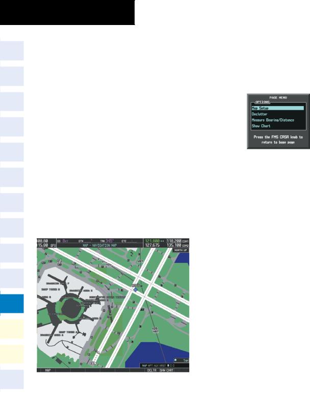
1)While viewing the Navigation Map Page, press the MENU Key to display the PAGE MENU.
2)Turn the large FMS Knob to highlight the Map Setup Menu Option and press the ENT Key.
Figure 11-14 Navigation Map PAGE MENU
3)Turn the FMS Knob to select the Aviation Group and press the ENT Key.
4)Turn the large FMS Knob to scroll through the Aviation Group options to SAFETAXI.
5)Turn the small FMS Knob to display the range of distances.
6)Turn either FMS Knob to select the desired distance for maximum SafeTaxi display range.
7)Press the ENT Key to complete the selection.
8)Press the FMS Knob to return to the Navigation Map Page.
11-10 |
Garmin G1000 Cockpit Reference Guide for the Cessna Nav III |
190-00384-09 Rev. A |