

314 |
F. Corrado and E. Durbiano |
In 2006, the Alpine Convention drafted a document entitled the Declaration on Population and Culture, signed by all member states within the Alpine region, where it is forcefully stated that the safeguarding and development of the Alpine territory requires the “strengthening [of] community awareness and the identity of the people who live in it”.
Now we should not forget that around 16% of terraced areas are in mountainous regions and a high proportion of those are found in the Alps, where the construction of terraces “represents a system of improvements that stem from traditional expertise to do with construction and cultivation techniques and with a perfect understanding of hydrogeological characteristics and climate that can make the most of environmental resources” (Agnoletti 2010). Thus, terraces are entirely involved in that relationship between know-how and local communities that builds an awareness of places: “we need a proactive, informed population that can combine local knowledge with expert knowledge through forms of participatory democracy if we want to care for and reconstruct places in order to attribute value to heritage in a long-term, sustainable manner” (Magnaghi 2006: 4).
As regards this aspect, territorial resources (meaning terraces) should be recognised and reinterpreted by communities using what Bonomi (2009) defines as “place awareness” in contemporary terms. Exercising an awareness of place means supporting processes and policies designed to strengthen the interpretational capacity of a territory and its development. Place awareness, built in this way on short local networks, comes into contact with long networks and hybridises and adjusts in line with modern life and its changes.
If we want to give these territories strategic strength, we must entirely overturn our approach and opt for a debate, a plan, a promotion of active citizenship until we achieve real cooperation at a supra-local level. In this way, we can come to adopt new rationales of knowledge production that are based on the narrative experiences of local communities where practices, innovation and experimentation emerge in an interactive, multidimensional way across the board, allowing us to go on to build a new territorial image, one which remains incomplete. Such an image contributes to building local territorial strategies using agreements that bring together the various different players within strategic local and supra-local frameworks within a circular and trans-scalar process.
19.3The Alto Canavese Case Study (Piedmont, Italy)
19.3.1A Territory that Looks to a Future Based on Terraced Landscapes
It is easy to understand the complex nature of the meanings and value of terraced landscapes if we consider the definition found in the Honghe Declaration (2010) where terraces are described as “agricultural, ecological systems” that should be
19 Innovative Practices and Strategic Planning on Terraced … |
315 |
protected due to their biological and cultural diversity. What we are dealing with here are specific features with a strong identity that can have a significant effect on the quality of life of the local community and on sustainable development, agricultural food products and the sense of belonging to a particular place.
To this end, we must keep terraces alive, not just as a piece of history but above all as pieces of territory that make a significant contribution to a territory’s stability and production. Terraced landscapes are often places where farm products are grown, sometimes in a heroic fashion; such produce contributes to the creation of economic systems and helps establish specific identities. Many different people work in different ways on terraced landscapes in order to maintain and restore drystone walls, often through daily efforts, and they play an important role in constructing the local community’s identity and sense of belonging.
The case study in question concentrates on these aspects, restoring an approach/ process towards the reconstruction of identity in a territory located in the north-west Italian Alps. It is an interesting case because the terraces, along with other features of the territory, were the basis upon which a heritage framework was reconstructed which could provide a new horizon of meaning for the territory and the sharing of a common heritage that could bring people together.
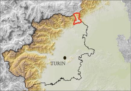
To be more precise, the case study concerned the northern end of Piedmont on the border with the Aosta Valley region, which includes the towns of Carema, Settimo Vittone, Nomaglio, Borgofranco d’Ivrea, Lessolo, Andrate, Chiaverano and Montalto Dora. It acts as a link between a number of different elements: firstly, between the Alps and the morainic hills of Serra. This territory extends along an elevation gain of over 2000 m, from the valley floor to the 2371 m of Colma di Mombarone. It is a transit corridor that extends along the Dora Baltea River and features the constant presence of terraces, an element that is immediately noticeable and highly recognisable. The favourable microclimate has encouraged the formation of a particular agricultural landscape featuring stone-walled terraces covered in vineyards. This landscape is characterised by traditional tupiun and pilun, features of the rural architecture of the past that when viewed as a whole produce a system that is clearly identifiable and boasts a strong identity.
A good number of local subjects already see that these terraces can play a new economic, social and environmental role as one of the territory’s most significant resources. Such experience was gained with the use of various different methods and practices due to the specific circumstances of each area. This territory’s development began a number of years ago, in 2013, when—faced by town planning choices made by Regione Piemonte, Piedmont’s regional government, to locate waste sites in these marginal areas on the edge of Turin’s metropolitan area—a group of mayors were inspired to rediscover the strengths of their territory, publicise its beauty and history and attempt to construct a new future from local resources—particularly its terraces—and a new Alpine community, one that, in the past, has been excessively damaged by top-down decisions made in Turin (Fig. 19.1).
316 |
F. Corrado and E. Durbiano |
Fig. 19.1 Strategic plan area of Alto Canavese inside Turin metropolitan city
19.3.2The Community’s First Steps: The Practices that Enhance Terraces
Three practices have had a pivotal and decisive role in the reconstruction of this territory’s identity and have provided the basis for the local community’s initial approach to the terraced landscape.
The first concerns the vineyard trail in the borough of Carema. The Carema project aims to promote the territory using a trail that allows visitors to explore the area’s historical and architectural features and its wine-making heritage. Visitors are given the chance to grasp the value of the topiary architecture that has left such an indelible sign on Carema’s landscape, and visit the land that produces Carema wine. The route consists of a circuit 4 km long in total with an elevation gain of 100 m that is accessible all year round and takes in all the town’s most important features, including—above all—the terraces closest to the town. This practice involves a series of local players who, in different ways, use the terraces (farmers, sports enthusiasts, hikers, grape growers) as well as prominent businesses, particularly the Nebbiolo wine producers of Carema. The local authority has, for some time now, begun to promote this trail through many initiatives that take place throughout the year, and through its support for the labelled recognition of the quality of its wines, particularly D.O.C. and Slow Food certifications.
The second practice concerns the “heroic” farming in Settimo Vittone. The borough council with support from the former provincial government of Turin
19 Innovative Practices and Strategic Planning on Terraced … |
317 |
(Department of Agriculture, Mountains, Protection of Fauna and Flora, Parks and Protected Areas) has promoted the “Plant an Olive Tree” project designed to increase the number of plants found in the borough and which has resulted in a twofold result: an increase in the amount of cultivated land and the reversal of the trend that saw the abandonment of such land. The project involved assigning olive saplings to local land owners who committed themselves to till abandoned, fallow land that is suitable for growing olive trees and start cultivating olives, a practice that has a long tradition in the area. The requirements that had to be met in order to be awarded the plants included that the land had to be facing south-east to south-west, land that mostly featured terraces. The result was the salvaging of a large portion of territory, the revival of a traditional crop that can generate new economic growth right from the start and a new/renewed interest in the local landscape among residents. This interest has begun to foster a desire to share knowledge and promote common heritage. The third practice concerns Nomaglio’s chestnut ecomuseum. In 1996, Nomaglio’s borough council launched a project designed to recuperate and promote vestiges of material culture found in the area. To this end, it set up an ecomuseum devoted to the farming of sweet chestnuts, which for centuries was a fundamental crop that provided all kinds of benefits. The town, the surrounding woods, chestnut groves, mule tracks, chestnut drying sheds and the mill are all pieces of a mirror that reflects Nomaglio’s community, where people recognise their reflected image and search for the values that underpin it. Nomaglio’s chestnut ecomuseum is therefore, unlike others, an open-air ecomuseum whose main theme is the territory; it is an itinerary for the exploration of the sweet chestnut landscape and the tools needed to produce chestnuts as marketable products (Fig. 19.2).
Fig. 19.2 Community activities on terracing of Nomaglio Photo Municipality of Settimo Vittone