

Practice
Prepare a presentation on any topic related to the Russian-Japanese partnership you have chosen yourself (e. g. the Russian-Japanese partnership in different spheres: culture / education / economy, etc).
UNIT 3. CHINA
Section 1. LOCATION
Reading
Scan the text below and do the assignment that follows.
Located in Southeast Asia along the coastline of the Pacific Ocean, China is the world’s third largest country, after Russia and Canada. With an area of 9,6 million square kilometers and a coastline of 18,000 kilometers, its shape on the map is like a rooster. It reaches Mohe in Heilongjiang Province as its northern end, Zengmu Ansha (or James Shoal) to the south, Pamirs to the west, and expands to the eastern border at the conjunction of the Heilongjiang (Amur) River and the Wusuli (Ussuri) River, spanning about 50 degrees of latitude and 62 degrees of longitude. China is bordered by 14 countries – Korea, Vietnam, Laos, Burma, India, Bhutan, Nepal, Pakistan, Afghanistan, Tajikistan, Kyrgyzstan, Kazakhstan, Mongolia, and Russia. Marine-side neighbors include eight countries – North Korea, Korea, Japan, Philippines, Brunei, Indonesia, Malaysia and Vietnam.
China is a mountainous country, with two-thirds of its total land area covered by mountains, hills and plateaus. Out of the world’s twelve high peaks of more than 8,000 meters, seven are located in China. The Highest peak in the world, Mount Qomolangma (8,828 m) stands on the border between China and Nepal.
T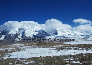 here
are five major mountain systems in China. These mountain systems,
together with numerous intermontane plateaus, basins, and plains are
interwoven into three macro landform complexes in China. Therefore,
the topography of China from the Qinghai-Xizang Plateau eastward is
broadly arranged into four great steps descending step-by-step from
the Qinghai-Tibet Plateau to the coastal area in the east.
here
are five major mountain systems in China. These mountain systems,
together with numerous intermontane plateaus, basins, and plains are
interwoven into three macro landform complexes in China. Therefore,
the topography of China from the Qinghai-Xizang Plateau eastward is
broadly arranged into four great steps descending step-by-step from
the Qinghai-Tibet Plateau to the coastal area in the east.
The Qinghai-Tibet Plateau, the top of the staircase, covers 2,2 million square kilometers and averages 4,000 meters above sea level. It is the highest and largest plateau on earth and is popularly called “roof of the world”.
From the eastern margin of Qinghai-Xizang Plateau eastward up to the Da Hinggan-Taihang-Wushan mountains line, composed mainly of plateau and basins with elevation from 2,000 to 1,000 kilometers.
From the above-mentioned line eastward up to the coast are the largest plains of China. The plains are also interspersed with hills generally below 500 kilometers in elevation.
C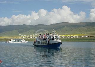 hina
has a great number of rivers. The inland river system accounts for 36
per cent of the total land area in China, more than 1,500 square
kilometers of which have a catchment area exceeding 1,000 square
kilometers. Among these, the Yangtze River, Yellow River,
Heilongjiang River, Pearl River, and Huaihe River are the major ones.
hina
has a great number of rivers. The inland river system accounts for 36
per cent of the total land area in China, more than 1,500 square
kilometers of which have a catchment area exceeding 1,000 square
kilometers. Among these, the Yangtze River, Yellow River,
Heilongjiang River, Pearl River, and Huaihe River are the major ones.
The Yangtze River is the longest river in China and the third longest in the world. It has a total length of 6,300 kilometer and a drainage area of more than 1,800,00 square kilometers. It is an arterial waterway connection such important cities as Shanghai, Nanjing, Wuhan, and Chongqing.
The Yellow River is the second longest river in China. It has a total length of 5,464 kilometers. On its banks lie Lanzhou, Baotou, Zhengzhou, Jinan and other important cities. The Yellow River Valley is considered the cradle of Chinese civilization.
China is also a country with numerous lakes. Approximately 2,800 natural lakes with total area more than 80,000 square kilometers. Five major lake regions can be identified: the Northern Lake Region, the Northwester Lake Region, the Qinghai-Xizang Lake Region, the Eastern Lake Region, the Southwest Lake Region.
(from http://www.columbia.edu; http://www.travelchinaguide.com)
Assignment
Using the map, describe the main features of the physical geography of China.
Practice
Using information from library resources and the Internet, comment on the following old saying:
“If you dig a hole in your back yard and keeping digging, you’ll end up in China”.
Section 2. SOME POINTS OF CHINESE HISTORY
Getting Started
Consider the basic events and the periods of Chinese history and say which of them were familiar and which were new to you.
Historical Setting
The Ancient Dynasties
Dawn of History
Zhou Period
Hundred Schools of Thought
The Imperial Era
First Imperial Period
Era of Disunity
Restoration of Empire
Mongolian Interlude
Chinese Regain Power
Rise of the Manchus
Emergence Of Modern China
Western Powers Arrive First Modern Period
Opium War, 1839–1842 Era of Disunity
Taiping Rebellion, 1851–1864
Self-Strengthening Movement
Hundred Days’ Reform and Aftermath
Republican Revolution of 1911
Republican China
Nationalism and Communism
Opposing the Warlords
Consolidation under the Guomindang
Rise of the Communists
Anti-Japanese War
Return to Civil War
People's Republic Of China
Transition to Socialism, 1953-1957
Great Leap Forward, 1958-1960
Readjustment and Recovery, 1961-1965
Cultural Revolution Decade, 1966-1976
Militant Phase, 1966–1968
Ninth National Party Congress to the Demise of Lin Biao, 1969–1971
End of the Era of Mao Zedong, 1972-1976
Post-Mao Period, 1976–1978
China and the Four Modernizations, 1979–1982
Reforms, 1980–1988
(from http://www.travelchinaguide.com; http://www-chaos.umd.edu)