

SpeakingOilGas
.pdfA common stratigraphic trap is a buried coral reef which is sealed by the surrounding claystones and shales. Often the reef itself has extremely high porosity and permeability and can give prodigious flow rates when tapped. The Leduc field in Alberta, Canada is an excellent example.
Another type occurs as a truncation, formed when erosion planes an exposed land surface and sediments are deposited directly on top during a later phase of the sedimentary cycle, thus sealing the older rocks. Where there is marked angular difference between the older and newer rocks, the contact is said to be an unconformity.
Unconformity or truncation traps
16 |
SPEAKING OIL & GAS |
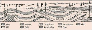
A further type of stratigraphic trap can occur when sandy river beds, deltas or beaches become buried as sand lenses. They form traps when they are surrounded by finer grained impervious sediments. Changes in the type and appearance of rocks (such as grain size) occur frequently in regressive and transgressive sediments. For instance, coarse grained sand is deposited in shallow waters, but the fine sediments are lighter and are carried further to be deposited in deeper waters. Thus a porous sandstone may gradually ‘shale out’, i.e. change into an impervious shale or siltstone.
Combination traps
Combination traps are those formed by both stratigraphic and structural means. In these cases the structure, whether it be a fault, anticline or just regional dip, does not form the trap alone. It must be associated with a stratigraphic component, such as a facies change or a truncation.
Types of oil and gas traps
GEOLOGY |
17 |

Chapter 2. SURVEYS
An accumulation of oil and gas is the product of a whole series of chance events, including the presence of a source rock, burial of the source rock, a reservoir and a trap in the right geometrical and historical relationships. Predicting if and where all these critical events have occurred in the correct succession is no simple matter, and it is certainly not foolproof. Nevertheless, the petroleum industry has built up a series of survey techniques to minimise the risks and delineate bona fide targets.
Field geology
The traditional method of finding oil was by mapping the surface geology and studying the relationships of the various rock units. Efforts were concentrated on mapping visible structures and potential reservoir rocks in areas that had some indication of hydrocarbons — like surface seeps.
18 |
SPEAKING OIL & GAS |
Petroleum exploration onshore still begins with a scrutiny of field geology, aiming to understand and predict the types of rock that might be expected in the subsurface, in prospects outlined by sophisticated geophysical means. Often the geological survey will begin with a review of large scale maps of the region and all previous smaller scale maps drawn, and reports written about specific areas of interest. This will be collated with aerial photographs and satellite imagery of the region in question. Geologists identify the rocks in outcrop and, if possible, map the boundaries of rock units along with any subsurface structural features. Even when the potential targets are offshore, it is often useful to sample and study rock outcrops on land that dip down under the ocean. More recently, the combination of electronic and seismic surveys and computerisation has enabled explorers to map and construct models of the subsurface in great detail and display these on the computer screen, in an effort to understand the formation and detect the presence of potentially petroleum-bearing features.
Geophysics
The principle behind geophysical surveys is to identify a contrast to the general background of data taken from a given region. In other words, the geophysicist is looking for an anomaly in relation to the surroundings. Usually the geophysical data is presented and analysed as some form of image.
Non-seismic techniques
Gravity surveys
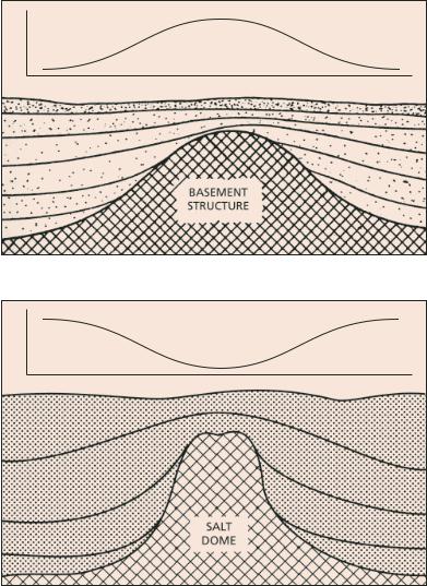
Gravity surveys aim to detect large-scale subsurface structures by means of the disturbance they produce in the earth’s gravitational field at ground level. The technique involves measuring the force of gravity at points on the earth’s surface or alternatively by measuring gravity gradient data via airborne means. Variations in gravity are caused by changes in the mass (hence the density) of subsurface rocks in the vicinity of the measuring point. The gravity survey attempts to detect these variations in gravitational pull.
SURVEYS |
19 |
MILLIGALS
TRAVERSE DISTANCE
Gravity anomalies relate to geological structure. High values caused by dense rocks near surface
MILLIGALS
TRAVERSE DISTANCE
Gravity anomalies relate to geological structure. Low values caused by light rocks near surface
20 |
SPEAKING OIL & GAS |
Because density usually increases with depth, a structural uplift generally brings denser rocks nearer to the surface and laterally adjacent to less dense sediments. Such uplifts are usually associated with higher gravity readings than the surroundings although, in the case of salt domes whose very reason for rising is their low density, it will be marked by low or negative readings in relation to the surroundings. Gravity techniques were first developed for detecting salt domes in the Gulf of Mexico region.
Station heights and water depths (in the case of offshore work) have to be accurately known, as does data on rock densities in the area under study, so that corrections can be made for elevation and terrain topography. Corrections are also made for latitude (the earth’s rotation and bulge at the equator produce an increase in gravity with latitude), earth tides caused by the sun and the moon (they depend on latitude and time) and density variations in the earth’s crust (which is generally more dense below oceans and less dense below land). The gravity measurements are then plotted on maps (nowadays on computer screens) and equal values are contoured with lines called isogals. If all the reductions have been made correctly, the resulting map should reflect only gravity changes due to subsurface geological structure. The modern techniques produce contrasting colourations on-screen that clearly highlight the lighter and denser material.
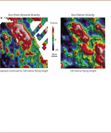
Historically, detailed gravity surveys were conducted on the ground, using a helicopter in rugged terrain, or on a ship. Because of the large and rapid changes in acceleration from aircraft movements, airborne gravity surveys were not as reliable or accurate. However, with the development in the 1990s of the FALCON® airborne gravity gradiometer system by BHP Billiton (from US Navy technology), fast, cost-effective and detailed gravity surveys can now be acquired over large areas by aircraft. Where ground surveys may take months or years in very difficult areas, a FALCON® survey can be completed in a few days.
Since the new millennium, satellite gravity data (originally developed for military purposes) has been available for all oceans of the world and is now used extensively by petroleum companies for exploration of offshore
SURVEYS |
21 |
Surface vs Airborne Gravity
About FALCON®
FALCON® is an airborne gravity gradiometer (AGG) that measures minute changes in the earth’s gravity. This technology has enormous benefits and gives BHP Billiton a unique competitive advantage in the search for mineral and hydrocarbon deposits.
This competitive advantage is backed by BHP Billiton’s unique value-added processing and interpretation capabilities.
Three AGG systems have been built to date, and are currently operational in Cessna Grand Caravans.
*BHP Billiton has 10.5 exclusivity years for mineral exploration and 10 years exclusivity for hydrocarbons, beginning October 1999. This means Lockheed Martin cannot build this technology for other parties during this period.
22 |
SPEAKING OIL & GAS |
regions. The technique compares differences in sea levels and is based on the fact that the shape of the sea surface is controlled by the earth’s gravitational field. Ridges and trenches on the ocean floor create variations in the height of the sea level and they can still be detected when corrections have been made for the effects of winds and currents. When a variation in sea level is detected where there is no rise or fall in the sea bed topography, then the anomaly causing the variation is under the sea bed. The data is then subjected to editing and image enhancement to produce colour maps of the structural composition of the earth’s upper crust.
In summary, gravity surveys are a useful primary exploration tool that can detect the gross outline of a basin, its structure and the depth to basement. It can also detect major faulting and folding, salt domes and shallow reef structures within the basin sediments.
Magnetic surveys
Magnetic surveys are similar in data acquisition and presentation to gravity surveys and the two techniques are often conducted together. The method depends on the fact that most rocks contain small, but significant amounts of ferromagnetic minerals like magnetite, ilmenite and pyrrhotite. Rocks therefore have a weak magnetism which is partly induced by the earth’s magnetic field and partly permanent. Thus a magnetic survey measures local variations in magnetic field.
The most important fact in magnetic exploration for petroleum is that sedimentary rocks are nearly non-magnetic and have a very small response compared to basement rocks and intrusions of volcanic and igneous rock. Thus a magnetic anomaly generally indicates a lack of sediments and the survey technique is used to rule out areas that are of no interest for the petroleum explorer. They are particularly useful in outlining the regional framework of sedimentary basins. Recent advances can also give an indication of faulting (because magnetic minerals are often concentrated in a fault plane) and individual structural elements within a basin.
SURVEYS |
23 |

Satellite Gravity — East Indonesia
Australian Continental Shelf
Satellite-derived Bouguer gravity for East Indonesia. Land areas are white, gravity values increase from blue to red. Dark blue area (left centre) is the Weber Deep
— water depth in excess of 7000 metres.
Satellite gravity image courtesy of GETECH, University of Leeds
24 |
SPEAKING OIL & GAS |
Once again, salt domes provide an opposite reaction. Salt is diamagnetic and tends to oppose the field that is polarising it. This results in a magnetic low.
Magnetic surveys can be conducted on the surface using land vehicles or ships, but the most common technique for a more complete coverage is by air — generally flying at heights of 60 metres above ground and 80 metres above sea. Accurate positioning and elevation are critical — a need answered by today’s extremely accurate positioning systems and satellite navigation systems. Corrections can also be made for the high speed flight.
As with gravity, image enhancement and contrasting colouration can now produce visually strong maps of the structural elements of an area under study.
In summary, magnetic surveys are a useful primary exploration tool that can detect the gross outline of sedimentary basins as well as the depth to basement, basement faulting, the presence of volcanics such as sills and dykes and mineralised alteration zones sometimes due to the presence of salt domes and hydrocarbons.
Geochemical surveys
Geochemical surveys are often undertaken in conjunction with other survey techniques. Exploration geochemistry follows a path that begins with characterising oil or gas samples taken from wells, or seeps. In the marine environment seeps (small oil slicks on the surface of the sea) may be detected by airborne or satellite imagery and attempts can be made to obtain core samples (known as drop cores) by dropping core barrels into the sea bed at that location. The samples are analysed and grouped into types of hydrocarbons. Even in seeps where weathering of the hydrocarbons may have taken place, detailed analyses can identify the original hydrocarbons.
Once samples have been classified into hydrocarbon ‘families’ the geochemist tries to correlate them back to source rocks in the basin. The data is built up into a computer model which is then tested in the field.
SURVEYS |
25 |