

FLIGHT MANAGEMENT
MAP SYMBOLS
This section discusses the types of land and aviation symbols that can be displayed. Each listed type of symbol can be turned on or off, and the maximum range to display each symbol can be set. The decluttering of the symbols from the map using the DCLTR Softkey is also discussed.
LAND SYMBOLS
The following items are configured on the land menu:
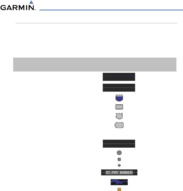
Land Symbols |
|
Symbol |
Default |
Maximum |
(Text label size can be None, Small, Medium (Med), or Large |
|
Range (nm) |
Range (nm) |
|
(Lrg) |
|
|
|
|
Latitude/Longitude (LAT/LON) |
|
|
Off |
2000 |
|
|
|
|
|
Highways and Roads |
|
|
|
|
|
|
|
|
|
Interstate Highway (FREEWAY) |
|
|
300 |
800 |
|
|
|
|
|
International Highway (FREEWAY) |
|
|
300 |
800 |
|
|
|
|
|
US Highway (NATIONAL HWY) |
|
|
30 |
80 |
|
|
|
|
|
State Highway (LOCAL HWY) |
|
|
15 |
30 |
|
|
|
|
|
Local Road (LOCAL ROAD) |
|
N/A |
8 |
15 |
|
|
|
|
|
Railroads (RAILROAD) |
|
|
15 |
30 |
|
|
|
|
|
LARGE CITY (> 200,000) |
|
|
800 |
1500 |
|
|
|
|
|
MEDIUM CITY (> 50,000) |
|
|
100 |
200 |
|
|
|
|
|
SMALL CITY (> 5,000) |
|
|
20 |
50 |
States and Provinces (STATE/PROV) |
|
|
800 |
1500 |
|
|
|
|
|
Rivers and Lakes (RIVER/LAKE) |
|
|
200 |
500 |
|
|
|
|
|
USER WAYPOINT |
|
|
150 |
300 |
|
|
|
|
|
Table 5-1 |
Land Symbol Information |
|
|
|
190-00498-03 Rev.A |
Garmin G1000 Pilot’s Guide for Cessna Nav III |
5-17 |
FLIGHT MANAGEMENT
AVIATION SYMBOLS
The following items are configured on the aviation menu:
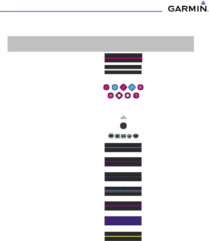
Aviation Symbols |
Symbol |
Default |
Maximum |
(Text label size can be None, Small, Medium (Med), |
|
Range (nm) |
Range (nm) |
or Large (Lrg) |
|
|
|
Active Flight Plan Leg (ACTIVE FPL) |
|
2000 |
2000 |
|
|
|
|
Non-active Flight Plan Leg (ACTIVE FPL) |
|
2000 |
2000 |
|
|
|
|
Active Flight Plan Waypoint (ACTIVE FPL WPT) |
See Airports, NAVAIDs |
2000 |
2000 |
Large Airports (LARGE APT) |
|
250 |
500 |
Medium Airports (MEDIUM APT) |
|
150 |
300 |
Small Airports (SMALL APT) |
|
50 |
100 |
Taxiways (SAFETAXI) |
See Section 8 |
3 |
20 |
Runway Extension (RWY EXTENSION) |
N/A |
Off |
100 |
Intersection (INT WAYPOINT) |
|
15 |
30 |
|
|
|
|
Non-directional Beacon (NDB WAYPOINT) |
|
15 |
30 |
|
|
|
|
VOR (VOR WAYPOINT) |
|
150 |
300 |
|
|
|
|
Class B Airspace/TMA (CLASS B/TMA) |
|
200 |
500 |
|
|
|
|
Class C Airspace/TCA (CLASS C/TCA) |
|
200 |
500 |
|
|
|
|
Class D Airspace (CLASS D) |
|
150 |
300 |
|
|
|
|
Restricted Area (RESTRICTED) |
|
200 |
500 |
|
|
|
|
Military Operations Area [MOA(MILITARY)] |
|
200 |
500 |
|
|
|
|
Other/Air Defense Interdiction Zone (OTHER/ADIZ) |
|
200 |
500 |
|
|
|
|
Temporary Flight Restriction (TFR) |
|
500 |
2000 |
|
|
|
|
Table 5-2 Aviation Symbol Information
5-18 |
Garmin G1000 Pilot’s Guide for Cessna Nav III |
190-00498-03 Rev.A |

FLIGHT MANAGEMENT
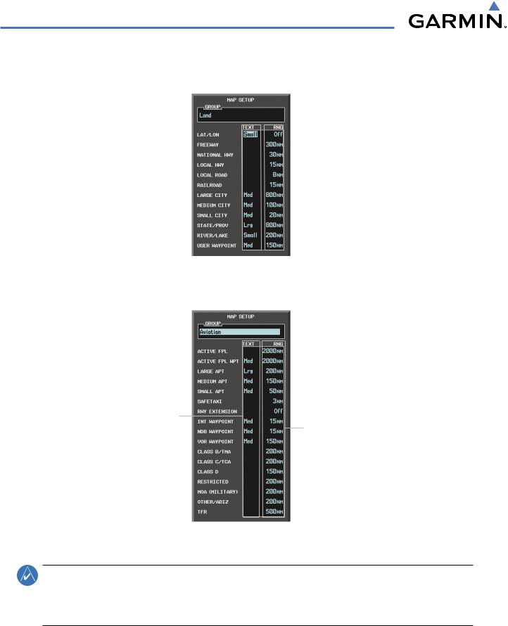
SYMBOL SETUP
All pages with maps can display land symbols (roads, lakes, borders, etc). Land symbols can be removed totally (turned off).
Displaying/removing all land symbols:
1)Press the MENU Key with the Navigation Map Page displayed. The Page Menu is displayed and the cursor flashes on the ‘Map Setup’ option.
2)Press the ENT Key. The Map Setup Group Menu is displayed and the cursor flashes on the ‘Map’ option.
3)Highlight the ‘LAND DATA’ field.
4)Select ‘On’ or ‘Off.’.
5)Press the FMS Knob to return to the Navigation Map Page.
LAND DATA
On/Off
Figure 5-18 Navigation Map Setup Menu - TOPO SCALE Setup
The label size (TEXT) sets the size at which labels appear on the display (none, small, medium, and large). The range (RNG) sets the maximum range at which items appear on the display.
Selecting a ‘Land’ or ‘Aviation’ group item text size and range:
1)Press the MENU Key with the Navigation Map Page displayed. The cursor flashes on the ‘Map Setup’ option.
2)Press the ENT Key. The Map Setup Menu is displayed.
3)Select the ‘Land’ or ‘Aviation’ group.
4)Press the ENT Key. The cursor flashes on the first field.
5)Select the desired land option.
6)Select the desired text size.
7)Press the ENT Key to accept the selected size.
6) Select the desired range.
190-00498-03 Rev.A |
Garmin G1000 Pilot’s Guide for Cessna Nav III |
5-19 |
FLIGHT MANAGEMENT
7)Press the ENT Key to accept the selected range.
8)Press the FMS Knob to return to the Navigation Map Page.
Text Label Size |
|
|
|
Maximum Display Range |
|
|
|||
(Off, Small Med, or Lrg) |
|
|||
|
|
|||
Figure 5-19 Navigation Map Setup Menu - LAND GROUP Setup
Text Label Size |
|
(Off, Small Med, or Lrg) |
Maximum Display Range |
Figure 5-20 Navigation Map Setup Menu - AVIATION GROUP Setup
NOTE: Since the PFD Inset Map is much smaller than the MFD navigation maps, items are removed on the PFD Inset Map two range levels smaller than the range selected in the Map Setup pages (e.g., a setting of 100 nm removes the item at ranges above 100 nm on MFD navigation maps, while the PFD Inset Map removes the same item at 50 nm).
5-20 |
Garmin G1000 Pilot’s Guide for Cessna Nav III |
190-00498-03 Rev.A |
FLIGHT MANAGEMENT
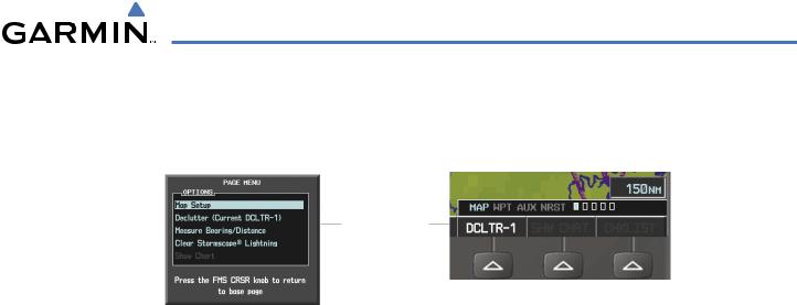
MAP DECLUTTER
The declutter feature allows the pilot to progressively step through four levels of removing map information. The declutter level is displayed in the DCLTR Softkey and next to the Declutter Menu Option.
Declutter Level
DCLTR Softkey
Navigation Map Page Menu
Figure 5-21 Navigation Map - Declutter Level Indications
Decluttering the map:
Press the DCLTR Softkey with the Navigation Map Page displayed. The current declutter level is shown. With each softkey selection, another level of map information is removed.
Or:
1)Press the MENU Key with the Navigation Map Page displayed.
2)Select ‘Declutter’. The current declutter level is shown.
3)Press the ENT Key.
Decluttering the PFD Inset Map:
1)Press the INSET Softkey.
2)Press the DCLTR Softkey. The current declutter level is shown. With each selection, another level of map information is removed.
190-00498-03 Rev.A |
Garmin G1000 Pilot’s Guide for Cessna Nav III |
5-21 |

FLIGHT MANAGEMENT
Table 5-3 lists the items displayed at each declutter level. The ‘X’ represents map items displayed for the various levels of declutter.
Item |
No Declutter |
Declutter-1 |
Declutter-2 |
Declutter-3 |
Flight Plan Route Lines |
X |
X |
X |
X |
Flight Plan Route Waypoints |
X |
X |
X |
X |
Rivers/Lakes |
X |
X |
X |
X |
Topography Data |
X |
X |
X |
X |
International Borders |
X |
X |
X |
X |
Track Vector |
X |
X |
X |
X |
Navigation Range Ring |
X |
X |
X |
X |
Fuel Range Ring |
X |
X |
X |
X |
Terrain Data |
X |
X |
X |
X |
Traffic |
X |
X |
X |
X |
Airways |
X |
X |
X |
X |
NEXRAD |
X |
X |
X |
|
XM Lightning Data |
X |
X |
X |
|
Airports |
X |
X |
X |
|
Runway Labels |
X |
X |
X |
|
Restricted |
X |
X |
X |
|
MOA (Military) |
X |
X |
X |
|
User Waypoints |
X |
X |
|
|
Latitude/Longitude Grid |
X |
X |
|
|
NAVAIDs |
X |
X |
|
|
Class B Airspaces/TMA |
X |
X |
|
|
Class C Airspaces/TCA |
X |
X |
|
|
Class D Airspaces |
X |
X |
|
|
Other Airspaces/ADIZ |
X |
X |
|
|
TFRs |
X |
X |
|
|
Obstacles |
X |
X |
|
|
Land/Country Text |
X |
|
|
|
Cities |
X |
|
|
|
Roads |
X |
|
|
|
Railroads |
X |
|
|
|
State/Province Boundaries |
X |
|
|
|
River/Lake Names |
X |
|
|
|
Table 5-3 Navigation Map Items Displayed by Declutter Level
5-22 |
Garmin G1000 Pilot’s Guide for Cessna Nav III |
190-00498-03 Rev.A |