

- •Section 1 System Overview
- •1.1 System Description
- •1.2 Line Replaceable Units (LRU)
- •1.3 G1000 Controls
- •PFD/MFD Controls
- •Audio Panel Controls
- •1.4 Secure Digital (SD) Cards
- •1.5 System Power-up
- •1.6 System Operation
- •Normal Display Operation
- •Reversionary Display Operation
- •AHRS Operation
- •G1000 System Annunciations
- •Softkey Function
- •GPS Receiver Operation
- •1.7 Accessing G1000 Functionality
- •Menus
- •MFD Page Groups
- •MFD System Pages
- •1.8 Display Backlighting
- •Automatic Adjustment
- •Manual Adjustment
- •Section 2 Flight Instruments
- •2.1 Flight Instruments
- •Airspeed Indicator
- •Attitude Indicator
- •Altimeter
- •Vertical Speed Indicator (VSI)
- •Vertical Deviation
- •Horizontal Situation Indicator (HSI)
- •Course Deviation Indicator (CDI)
- •2.2 Supplemental Flight Data
- •Outside Air Temperature
- •Wind Data
- •Vertical Navigation (VNV) Indications
- •2.3 PFD Annunciations and Alerting Functions
- •G1000 System Alerting
- •Marker Beacon Annunciations
- •Traffic Annunciation
- •TAWS Annunciations
- •Altitude Alerting
- •Low Altitude Annunciation
- •Minimum Descent Altitude/Decision Height Alerting
- •2.4 Abnormal Operations
- •Abnormal GPS Conditions
- •Unusual Attitudes
- •Section 3 Engine Indication System (EIS)
- •3.1 Engine Display
- •3.2 Lean Display
- •Normally-aspirated Aircraft
- •Turbocharged Aircraft
- •3.3 System Display
- •Section 4 audio panel and CNS
- •4.1 Overview
- •MFD/PFD Controls and Frequency Display
- •Audio Panel Controls
- •4.2 COM Operation
- •COM Transceiver Selection and Activation
- •COM Transceiver Manual Tuning
- •Quick-Tuning and Activating 121.500 MHz
- •Auto-tuning the COM Frequency
- •Frequency Spacing
- •Automatic Squelch
- •Volume
- •4.3 NAV Operation
- •NAV Radio Selection and Activation
- •NAV Receiver Manual Tuning
- •Auto-tuning a NAV Frequency from the MFD
- •Marker Beacon Receiver
- •DME Tuning (Optional)
- •4.4 GTX 33 Mode S Transponder
- •Transponder Controls
- •Transponder Mode Selection
- •Entering a Transponder Code
- •IDENT Function
- •Flight ID Reporting
- •4.5 Additional Audio Panel Functions
- •Power-Up
- •Mono/Stereo Headsets
- •Speaker
- •Intercom
- •Passenger Address (PA) System
- •Clearance Recorder and Player
- •Entertainment Inputs
- •4.6 Audio Panel Preflight Procedure
- •4.7 Abnormal Operation
- •Stuck Microphone
- •COM Tuning Failure
- •Audio Panel Fail-Safe Operation
- •Reversionary Mode
- •Section 5 Flight Management
- •5.1 Introduction
- •Navigation Status Box
- •5.2 Using Map Displays
- •Map Orientation
- •Map Range
- •Map Panning
- •Measuring Bearing and Distance
- •Topography
- •Map Symbols
- •Airways
- •Track Vector
- •Wind Vector
- •Nav Range Ring
- •Fuel Range Ring
- •5.3 Waypoints
- •Airports
- •Intersections
- •NDBs
- •VORs
- •User Waypoints
- •5.4 Airspaces
- •5.5 Direct-to-Navigation
- •5.6 Flight Planning
- •Flight Plan Creation
- •Adding Waypoints To An Existing Flight Plan
- •Adding Airways to a Flight Plan
- •Adding Procedures To A Stored Flight Plan
- •Flight Plan Storage
- •Flight Plan Editing
- •Along Track Offsets
- •Parallel Track
- •Activating a Flight Plan Leg
- •Inverting a Flight Plan
- •Flight Plan Views
- •Closest Point of FPL
- •5.7 Vertical Navigation
- •Altitude Constraints
- •5.8 Procedures
- •Departures
- •Arrivals
- •Approaches
- •5.9 Trip Planning
- •Trip Planning
- •5.10 RAIM Prediction
- •5.11 Navigating a Flight Plan
- •5.12 Abnormal Operation
- •Section 6 Hazard Avoidance
- •6.1 XM Satellite Weather
- •Activating Services
- •Using XM Satellite Weather Products
- •6.2 WX-500 Stormscope (Optional)
- •Setting Up Stormscope on the Navigation Map
- •Selecting the Stormscope Page
- •6.3 Terrain Proximity
- •Displaying Terrain Proximity Data
- •Terrain Proximity Page
- •6.4 TAWs (Optional)
- •Displaying TAWS Data
- •TAWS Page
- •TAWS Alerts
- •System Status
- •6.5 Traffic Information Service (TIS)
- •Displaying TRAFFIC Data
- •Traffic Map Page
- •TIS Alerts
- •System Status
- •6.6 Traffic Advisory System (TAS) (Optional)
- •TAS Symbology
- •Operation
- •Altitude Display
- •Traffic Map Page Display Range
- •TAS Alerts
- •System Status
- •6.7 ADS-B Traffic (Optional)
- •Section 7 Automatic Flight Control System
- •7.2 Flight Director Operation
- •Activating the Flight Director
- •AFCS Status Box
- •Command Bars
- •Flight Director Modes
- •7.3 Vertical Modes
- •Pitch Hold Mode (PIT)
- •Selected Altitude capture Mode (ALTs)
- •Altitude hold mode (alt)
- •Vertical Speed Mode (VS)
- •Flight Level Change Mode (FLC)
- •Vertical Navigation Modes (VPTH, ALTV)
- •Glidepath Mode (GP) (waas only)
- •Glideslope Mode (GS)
- •Go Around (GA) Mode
- •7.4 Lateral Modes
- •Roll Hold Mode (ROL)
- •Heading Select Mode (HDG)
- •Navigation mode (GPS, VOR, LOC)
- •Approach mode (GPS, VAPP, LOC)
- •Backcourse Mode (BC)
- •7.5 Autopilot Operation
- •Engaging the Autopilot
- •Control Wheel Steering
- •Disengaging the Autopilot
- •7.6 Example Procedures
- •Departure
- •Intercepting a VOR Radial
- •Flying a Flight Plan/GPS Course
- •Descent
- •Approach
- •Go Around/Missed Approach
- •7.7 AFCS Annunciations and Alerts
- •AFCS Status Alerts
- •Overspeed Protection
- •Section 8 Additional Features
- •8.1 SafeTaxi
- •SafeTaxi Cycle Number and Revision
- •8.2 ChartView
- •ChartView Softkeys
- •Terminal Procedures Charts
- •Chart Options
- •Day/Night View
- •ChartView Cycle Number and Expiration Date
- •8.3 FliteCharts
- •FliteCharts Softkeys
- •Terminal Procedures Charts
- •Chart Options
- •Day/Night View
- •FliteCharts Cycle Number and Expiration Date
- •8.4 XM Radio Entertainment (Optional)
- •Activating XM Satellite Radio Services
- •Using XM Radio
- •Automatic Audio Muting
- •8.5 Scheduler
- •8.5 Abnormal Operation
- •Annunciations and Alerts
- •Alert Level Definitions
- •Nav III Aircraft Alerts
- •CO Guardian Messages
- •G1000 System Annunciations
- •Other G1000 Aural Alerts
- •G1000 System Message Advisories
- •AFCS Alerts
- •TAWS ALERTS
- •TAWS System Status Annunciations
- •SD Card Use
- •Jeppesen Databases
- •Garmin Databases
- •Glossary
- •Frequently Asked Questions
- •General TIS Information
- •Introduction
- •TIS vs. TAS/TCAS
- •TIS Limitations
- •Map Symbols
- •Index
APPENDIX F
MAP SYMBOLS
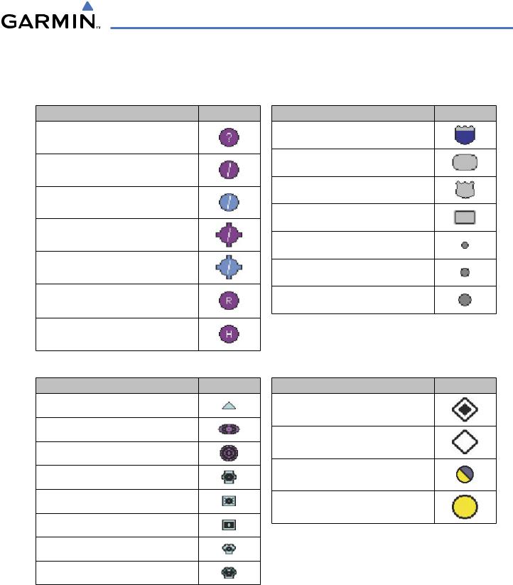
AIRPORT
Item Symbol
Unknown Airport
Non-towered, Non-serviced Airport
Towered, Non-serviced Airport
Non-towered, Serviced Airport
Towered, Serviced Airport
Restricted (Private) Airport
Heliport
NAVAIDS
Item Symbol
Intersection
LOM (compass locator at outer marker)
NDB (Non-directional Radio Beacon)
VOR
VOR/DME
VOR/ILS
VORTAC
TACAN
BASEMAP
Item |
Symbol |
Interstate Highway
State Highway
US Highway
National Highway
Small City or Town
Medium City
Large City
TRAFFIC
Item |
Symbol |
Non-Threat Traffic
Proximity Advisory
Traffic Advisory, Out of Range
Traffic Advisory
190-00498-03 Rev.A |
Garmin G1000 Pilot’s Guide for Cessna Nav III |
F-1 |
APPENDIX F
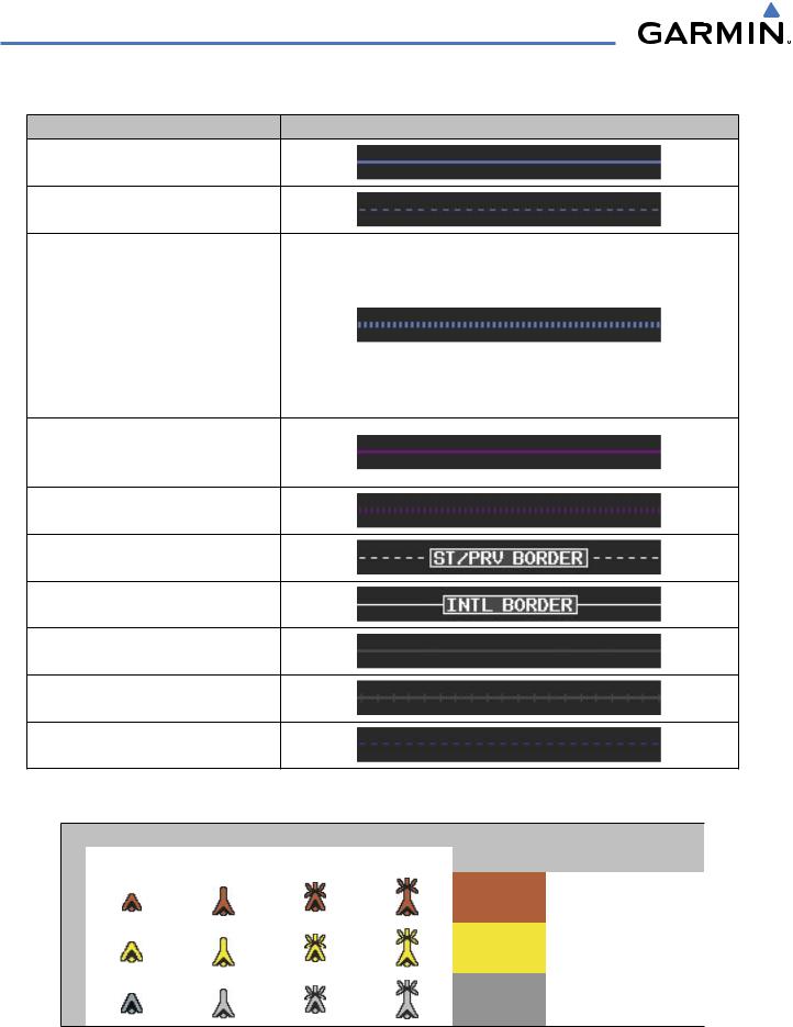
LINE SYMBOLS
Item |
Symbol |
ICAO Control Area
Class B Airspace
Mode C Tower Area
Warning Area
Alert Area
Caution Area
Danger Area
Prohibited Area
Restricted Area
Training Area
Unknown Area
Class C
Terminal Radar Service Area
Mode C Area
Military Operations Area (MOA)
State or Province Border
International Border
Road
Railroad
Lattitude/Longitude
OBSTACLE SYMBOLS
Obstacle Symbol
Unlighted Obstacle |
Lighted Obstacle |
Obstacle |
Obstacle Location |
|||
< 1000 ft AGL |
> 1000 ft AGL |
< 1000 ft AGL |
> 1000 ft AGL |
Color |
||
|
||||||
|
|
|
|
Red |
Obstacle within 100 ft or |
|
|
|
|
|
above aircraft altitude |
||
|
|
|
|
|
||
|
|
|
|
|
|
|
|
|
|
|
Yellow |
Obstacle within 1000 ft of |
|
|
|
|
|
aircraft altitude |
||
|
|
|
|
|
||
|
|
|
|
|
|
|
|
|
|
|
Gray |
Obstacle more than 1000 |
|
|
|
|
|
ft below aircraft altitude |
||
|
|
|
|
|
||
|
|
|
|
|
|
|
|
|
Table F-1 Obstacle Symbols and Colors |
|
|||
F-2 |
Garmin G1000 Pilot’s Guide for Cessna Nav III |
190-00498-03 Rev.A |
APPENDIX F
TERRAIN PROXIMITY COLOR CHART
Aircraft Altitude
100 ft Threshold
1000 ft
Terrain Color |
Terrain Location |
Red |
Terrain above or within 100 ft below aircraft altitude |
Yellow |
Terrain between 100 ft and 1000 ft of aircraft altitude |
Black |
Terrain more than 1000 ft below aircraft altitude |
Figure F-1 Terrain Proximity Colors
TAWS COLOR CHART
|
|
Potential Impact Point |
|
Projected Flight Path |
|
100' Threshold |
Unlighted Obstacle |
|
|
||
1000' |
|
|
|
Terrain Color |
Terrain Location |
|
Red (WARNING) |
Terrain above or within 100 ft below aircraft altitude |
|
Yellow (CAUTION) |
Terrain between 100 ft and 1000 ft of aircraft altitude |
|
Black (NO DANGER) |
Terrain more than 1000 ft below aircraft altitude |
Potential Impact Points
Figure F-2 TAWS Symbols & Colors
190-00498-03 Rev.A |
Garmin G1000 Pilot’s Guide for Cessna Nav III |
F-3 |
APPENDIX F
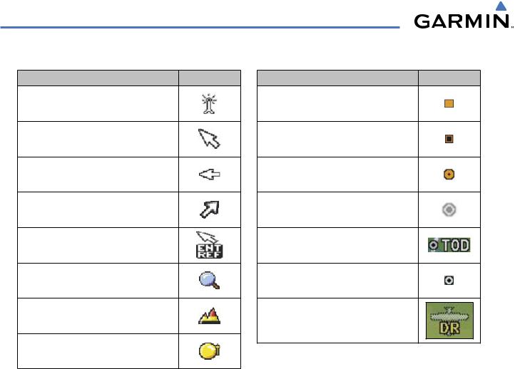
MISCELLANEOUS
Item |
Symbol |
ARTCC Frequency or FSS Frequency
Default Map Pointer
Elevation Pointer
Wind Vector
Measuring Pointer
Overzoom Indicator
Terrain Proximity or TAWS Enabled
Traffic Enabled
Item |
Symbol |
User Waypoint
Vertical Navigation Along Track Waypoint
Parallel Track Waypoint
Unanchored Flight Path Waypoint
Top of Descent (TOD)
Bottom of Descent (BOD)
Navigating using Dead Reckoning
F-4 |
Garmin G1000 Pilot’s Guide for Cessna Nav III |
190-00498-03 Rev.A |