

- •Section 1 System Overview
- •1.1 System Description
- •1.2 Line Replaceable Units (LRU)
- •1.3 G1000 Controls
- •PFD/MFD Controls
- •Audio Panel Controls
- •1.4 Secure Digital (SD) Cards
- •1.5 System Power-up
- •1.6 System Operation
- •Normal Display Operation
- •Reversionary Display Operation
- •AHRS Operation
- •G1000 System Annunciations
- •Softkey Function
- •GPS Receiver Operation
- •1.7 Accessing G1000 Functionality
- •Menus
- •MFD Page Groups
- •MFD System Pages
- •1.8 Display Backlighting
- •Automatic Adjustment
- •Manual Adjustment
- •Section 2 Flight Instruments
- •2.1 Flight Instruments
- •Airspeed Indicator
- •Attitude Indicator
- •Altimeter
- •Vertical Speed Indicator (VSI)
- •Vertical Deviation
- •Horizontal Situation Indicator (HSI)
- •Course Deviation Indicator (CDI)
- •2.2 Supplemental Flight Data
- •Outside Air Temperature
- •Wind Data
- •Vertical Navigation (VNV) Indications
- •2.3 PFD Annunciations and Alerting Functions
- •G1000 System Alerting
- •Marker Beacon Annunciations
- •Traffic Annunciation
- •TAWS Annunciations
- •Altitude Alerting
- •Low Altitude Annunciation
- •Minimum Descent Altitude/Decision Height Alerting
- •2.4 Abnormal Operations
- •Abnormal GPS Conditions
- •Unusual Attitudes
- •Section 3 Engine Indication System (EIS)
- •3.1 Engine Display
- •3.2 Lean Display
- •Normally-aspirated Aircraft
- •Turbocharged Aircraft
- •3.3 System Display
- •Section 4 audio panel and CNS
- •4.1 Overview
- •MFD/PFD Controls and Frequency Display
- •Audio Panel Controls
- •4.2 COM Operation
- •COM Transceiver Selection and Activation
- •COM Transceiver Manual Tuning
- •Quick-Tuning and Activating 121.500 MHz
- •Auto-tuning the COM Frequency
- •Frequency Spacing
- •Automatic Squelch
- •Volume
- •4.3 NAV Operation
- •NAV Radio Selection and Activation
- •NAV Receiver Manual Tuning
- •Auto-tuning a NAV Frequency from the MFD
- •Marker Beacon Receiver
- •DME Tuning (Optional)
- •4.4 GTX 33 Mode S Transponder
- •Transponder Controls
- •Transponder Mode Selection
- •Entering a Transponder Code
- •IDENT Function
- •Flight ID Reporting
- •4.5 Additional Audio Panel Functions
- •Power-Up
- •Mono/Stereo Headsets
- •Speaker
- •Intercom
- •Passenger Address (PA) System
- •Clearance Recorder and Player
- •Entertainment Inputs
- •4.6 Audio Panel Preflight Procedure
- •4.7 Abnormal Operation
- •Stuck Microphone
- •COM Tuning Failure
- •Audio Panel Fail-Safe Operation
- •Reversionary Mode
- •Section 5 Flight Management
- •5.1 Introduction
- •Navigation Status Box
- •5.2 Using Map Displays
- •Map Orientation
- •Map Range
- •Map Panning
- •Measuring Bearing and Distance
- •Topography
- •Map Symbols
- •Airways
- •Track Vector
- •Wind Vector
- •Nav Range Ring
- •Fuel Range Ring
- •5.3 Waypoints
- •Airports
- •Intersections
- •NDBs
- •VORs
- •User Waypoints
- •5.4 Airspaces
- •5.5 Direct-to-Navigation
- •5.6 Flight Planning
- •Flight Plan Creation
- •Adding Waypoints To An Existing Flight Plan
- •Adding Airways to a Flight Plan
- •Adding Procedures To A Stored Flight Plan
- •Flight Plan Storage
- •Flight Plan Editing
- •Along Track Offsets
- •Parallel Track
- •Activating a Flight Plan Leg
- •Inverting a Flight Plan
- •Flight Plan Views
- •Closest Point of FPL
- •5.7 Vertical Navigation
- •Altitude Constraints
- •5.8 Procedures
- •Departures
- •Arrivals
- •Approaches
- •5.9 Trip Planning
- •Trip Planning
- •5.10 RAIM Prediction
- •5.11 Navigating a Flight Plan
- •5.12 Abnormal Operation
- •Section 6 Hazard Avoidance
- •6.1 XM Satellite Weather
- •Activating Services
- •Using XM Satellite Weather Products
- •6.2 WX-500 Stormscope (Optional)
- •Setting Up Stormscope on the Navigation Map
- •Selecting the Stormscope Page
- •6.3 Terrain Proximity
- •Displaying Terrain Proximity Data
- •Terrain Proximity Page
- •6.4 TAWs (Optional)
- •Displaying TAWS Data
- •TAWS Page
- •TAWS Alerts
- •System Status
- •6.5 Traffic Information Service (TIS)
- •Displaying TRAFFIC Data
- •Traffic Map Page
- •TIS Alerts
- •System Status
- •6.6 Traffic Advisory System (TAS) (Optional)
- •TAS Symbology
- •Operation
- •Altitude Display
- •Traffic Map Page Display Range
- •TAS Alerts
- •System Status
- •6.7 ADS-B Traffic (Optional)
- •Section 7 Automatic Flight Control System
- •7.2 Flight Director Operation
- •Activating the Flight Director
- •AFCS Status Box
- •Command Bars
- •Flight Director Modes
- •7.3 Vertical Modes
- •Pitch Hold Mode (PIT)
- •Selected Altitude capture Mode (ALTs)
- •Altitude hold mode (alt)
- •Vertical Speed Mode (VS)
- •Flight Level Change Mode (FLC)
- •Vertical Navigation Modes (VPTH, ALTV)
- •Glidepath Mode (GP) (waas only)
- •Glideslope Mode (GS)
- •Go Around (GA) Mode
- •7.4 Lateral Modes
- •Roll Hold Mode (ROL)
- •Heading Select Mode (HDG)
- •Navigation mode (GPS, VOR, LOC)
- •Approach mode (GPS, VAPP, LOC)
- •Backcourse Mode (BC)
- •7.5 Autopilot Operation
- •Engaging the Autopilot
- •Control Wheel Steering
- •Disengaging the Autopilot
- •7.6 Example Procedures
- •Departure
- •Intercepting a VOR Radial
- •Flying a Flight Plan/GPS Course
- •Descent
- •Approach
- •Go Around/Missed Approach
- •7.7 AFCS Annunciations and Alerts
- •AFCS Status Alerts
- •Overspeed Protection
- •Section 8 Additional Features
- •8.1 SafeTaxi
- •SafeTaxi Cycle Number and Revision
- •8.2 ChartView
- •ChartView Softkeys
- •Terminal Procedures Charts
- •Chart Options
- •Day/Night View
- •ChartView Cycle Number and Expiration Date
- •8.3 FliteCharts
- •FliteCharts Softkeys
- •Terminal Procedures Charts
- •Chart Options
- •Day/Night View
- •FliteCharts Cycle Number and Expiration Date
- •8.4 XM Radio Entertainment (Optional)
- •Activating XM Satellite Radio Services
- •Using XM Radio
- •Automatic Audio Muting
- •8.5 Scheduler
- •8.5 Abnormal Operation
- •Annunciations and Alerts
- •Alert Level Definitions
- •Nav III Aircraft Alerts
- •CO Guardian Messages
- •G1000 System Annunciations
- •Other G1000 Aural Alerts
- •G1000 System Message Advisories
- •AFCS Alerts
- •TAWS ALERTS
- •TAWS System Status Annunciations
- •SD Card Use
- •Jeppesen Databases
- •Garmin Databases
- •Glossary
- •Frequently Asked Questions
- •General TIS Information
- •Introduction
- •TIS vs. TAS/TCAS
- •TIS Limitations
- •Map Symbols
- •Index
APPENDIX B
SD CARD USE
The G1000 System uses Secure Digital (SD) cards to load and store various types of data. For basic flight operations, SD cards are required for database storage as well as Jeppesen aviation and ChartView database updates.
JEPPESEN DATABASES
The Jeppesen aviation database is updated on a 28-day cycle. The ChartView database is updated on a 14day cycle. If the ChartView database is not updated within 70 days of the expiration date, ChartView will no longer function.
Both these databases are provided directly from Jeppesen. The ChartView database should be copied to the Garmin supplied Supplemental Data Card which will reside in the bottom card slot on the MFD. The aviation database may be installed from the Jeppesen supplied SD data card or copied to one of the Garmin supplied Supplemental Data Cards. Contact Jeppesen (www.jeppesen.com) for subscription and update information.
The aviation database may be programmed to only one of the Supplemental Data Cards. This card must then be used to update the PFD and the MFD.
 NOTE: After the aviation database is installed, the card may be removed after loading the update to each LRU.
Updating the Jeppesen aviation database:
1)With the G1000 System OFF, insert the SD card containing the aviation database update into the top card slot of the PFD to be updated (Label of SD card facing left).
2)Turn the G1000 System ON. A prompt similar to the following is displayed in the upper left corner of the PFD:
Figure B-1 Database Update Prompt
3) Press the ENT Key to start the database update. A prompt similar to the following is displayed:
Figure B-2 Database Update Confirmation
190-00498-03 Rev.A |
Garmin G1000 Pilot’s Guide for Cessna Nav III |
B-1 |
APPENDIX B
4)After the update completes, the PFD starts in normal mode.
5)Turn the G1000 System OFF and remove the SD card.
6)Repeat steps 1 through 4 for the MFD. The MFD and PFD databases are now updated. Remove the SD card when finished.
7)Verify that the correct update cycle is loaded during startup of the MFD.
GARMIN DATABASES
The following G1000 databases are available on a subscription basis and are stored on Supplemental Data Cards provided by Garmin:
• Expanded basemap |
• Obstacle |
• Terrain |
• SafeTaxi |
• Airport terrain |
• FliteCharts |
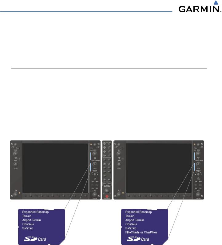
After subscribing to the desired database product, these database products will be downloaded to two Supplemental Data Cards (with the exception of FliteCharts, which is loaded on only one card). Insert each Supplemental Data Card into the correct location shown in Figure B-3. These cards must not be removed except to update the databases stored on each card.
PFD |
MFD |
Figure B-3 Correct Database Locations
Since databases are not stored internally in the MFD or PFD, a Supplemental Data Card containing identical database versions must be kept in each display unit.
The expanded basemap database contains data for the topography and land features, such as rivers, lakes, and towns. It is updated only periodically, with no set schedule. There is no expiration date for the expanded basemap database.
B-2 |
Garmin G1000 Pilot’s Guide for Cessna Nav III |
190-00498-03 Rev.A |

APPENDIX B
The terrain and airport terrain databases contain the terrain mapping and airport diagram data. They are updated periodically and have no expiration date.
The obstacle database contains data for locating man-made obstacles that pose a potential hazard to aircraft. Obstacles 200 feet and higher are included in the obstacle database. It is very important to note that not all obstacles are necessarily charted and therefore may not be contained in the obstacle database. This database is updated on a 56-day cycle.
 NOTE: The data contained in the terrain and obstacle databases comes from government agencies. Garmin accurately processes and cross-validates the data, but cannot guarantee the accuracy and/or completeness of the data.
TheSafeTaxidatabasecontainsdetailedairportdiagramsforselectedairports. Thesediagramsaidinfollowing ground control instructions by accurately displaying the aircraft position on the map in relation to taxiways, ramps, runways, terminals, and services. This database is updated on a 56-day cycle.
The FliteCharts database contains procedure charts for the United States only. This database is updated on a 28-day cycle. If not updated within 180 days of the expiration date, FliteCharts will no longer function.
UPDATING GARMIN DATABASES
The Garmin database updates can be obtained by following the instructions detailed in the ‘Aviation Databases’ section of the Garmin website (www.garmin.com). Once the updated files have been downloaded from the website, a PC equipped with an appropriate SD card reader is used to unpack and program the new databases onto the existing Supplemental Data Cards. Equipment required to perform the update is as follows:
•Windows-compatible PC computer (Windows 2000 or XP recommended)
•SanDisk SD Card Reader, P/Ns SDDR-93 or SDDR-99 or equivalent card reader
•Updated database obtained from the Garmin website
•Existing 010-00330-42 Supplemental Database SD Cards from both PFD and MFD
In some cases it may be necessary to obtain an unlock code from Garmin in order to make the database product functional. It may also be necessary to have the system configured by a Garmin authorized service facility in order to use some database features.
After the data has been copied to the appropriate data cards, perform the following steps:
1)Insert one SD card in the bottom card slot of the MFD and one in the bottom card slot of the PFD. The SD card containing the ChartView or FliteCharts database must be inserted into the bottom slot on the MFD.
2)Apply power to the G1000 System. View the MFD power-up splash screen. Check that the databases are initialized and displayed on the scrolling window of the splash screen. When updating the terrain and FliteCharts databases, an ‘in progress’ message may be seen. If this message is present, wait for the system to finish loading before verifying the correct databases are initialized, then proceed to step 3.
190-00498-03 Rev.A |
Garmin G1000 Pilot’s Guide for Cessna Nav III |
B-3 |
APPENDIX B
Figure B-4 Database Information on the Splash Screen
3)Acknowledge the Power-up Page agreement by pressing the ENT Key or the right most softkey.
4)Turn the large FMS Knob to select the AUX Page group on the MFD.
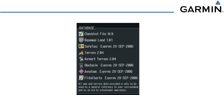
5)Turn the small FMS Knob to select the System Status Page.
6)Press the DBASE Softkey to place the cursor in the ‘DATABASE’ box.
7)Turn either FMS Knob to scroll through the database list and check that all databases are current and there are no errors.
8)Power down the G1000.
B-4 |
Garmin G1000 Pilot’s Guide for Cessna Nav III |
190-00498-03 Rev.A |