

FLIGHT MANAGEMENT
INTERSECTIONS
 NOTE: The VOR displayed on the Intersection Information Page is the nearest VOR, not necessarily the VOR used to define the intersection.
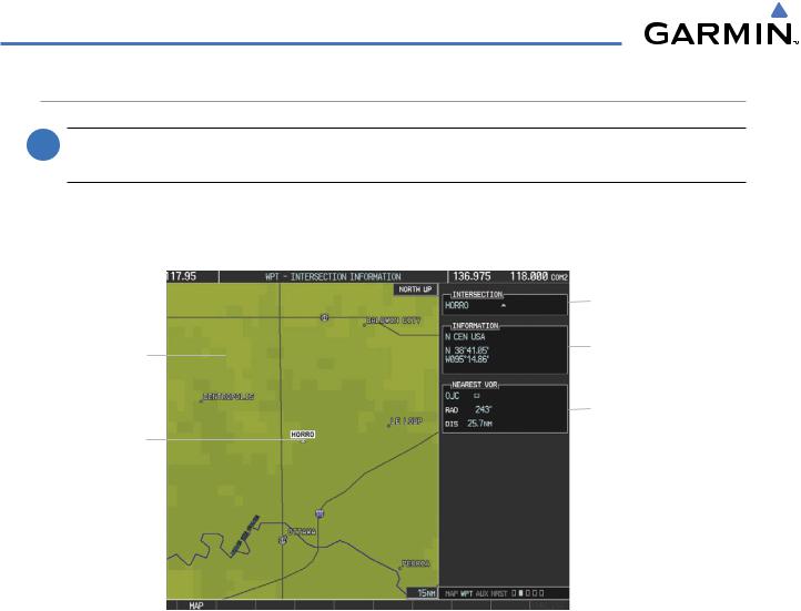
The Intersection Information Page is used to view information about intersections. In addition to displaying a map of the currently selected intersection and surrounding area, the Intersection Information Page displays intersection information in three boxes labeled ‘INTERSECTION’, ‘INFORMATION’, and ‘NEAREST VOR’.
|
|
Intersection Identifier |
Navigation Map |
|
Intersection Info |
|
||
|
||
|
- Region |
|
Showing Selected |
|
|
|
- Lat/Long |
|
|
||
Intersection |
|
|
|
||
|
|
|
|
|
Nearest VOR Info |
Selected |
|
- Identifier/Type (symbol) |
|
- Radial to VOR |
|
Intersection |
|
- Distance to VOR |
Figure 5-36 Intersection Information Page
Select an intersection:
1)With the Intersection Information Page displayed, enter an identifier in the Intersection Box.
2)Press the ENT Key.
3)Press the FMS Knob to remove the flashing cursor.
Or:
1)With the Nearest Intersections Page displayed, press the FMS Knob
2)Press the ENT Key or turn either FMS Knob to select an identifier in the Nearest Intersection Box.
3)Press the FMS Knob to remove the flashing cursor.
5-36 |
Garmin G1000 Pilot’s Guide for Cessna Nav III |
190-00498-03 Rev.A |
FLIGHT MANAGEMENT
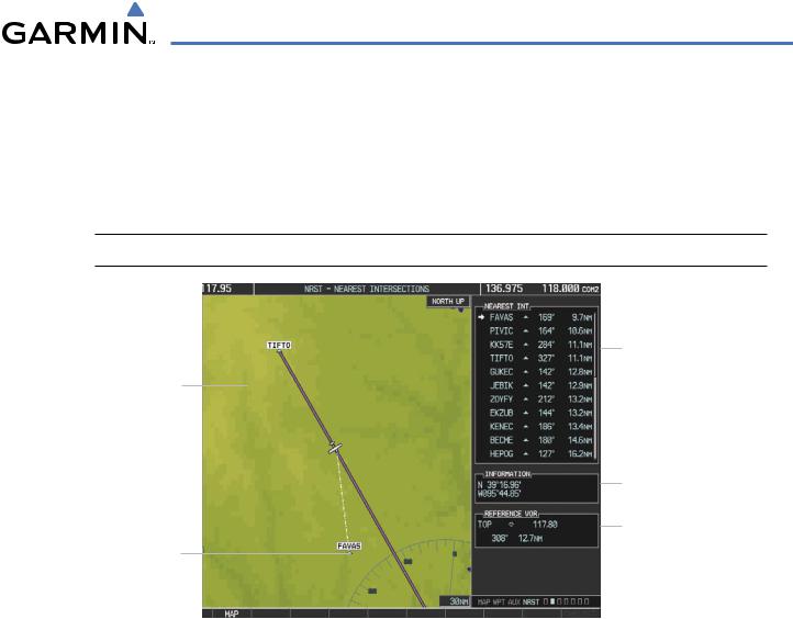
The Nearest Intersections Page can be used to quickly find an intersection close to the flight path. In addition to displaying a map of the surrounding area, the page displays information for up to 25 nearest intersections in three boxes labeled ‘NEAREST INT’, ‘INFORMATION’, and ‘REFERENCE VOR’.
The selected intersection is indicated by a white arrow. Up to eleven Intersections are visible at a time. If there are more than can be shown, the list can be scrolled. If there are no items for display, text indicating that fact is displayed
 NOTE: The list only includes waypoints that are within 200 nm.
|
|
Intersection Information |
|
|
- Identifier/Symbol |
Navigation Map |
|
- Bearing/Distance to |
|
intersection from |
|
Showing Nearest |
|
|
|
aircraft position |
|
Intersection |
|
|
|
|
|
|
|
|
|
|
Intersection Lat/Long |
|
|
Reference VOR Info |
|
|
|
|
|
|
Nearest Intersection |
|
- Identifier/Type (symbol) |
|
- VOR Frequency |
- Bearing/Distance to VOR
Figure 5-37 Nearest Intersections Page
190-00498-03 Rev.A |
Garmin G1000 Pilot’s Guide for Cessna Nav III |
5-37 |

FLIGHT MANAGEMENT
NDBS
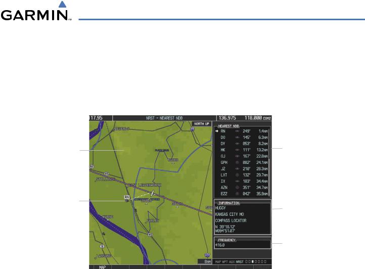
The NDB Information Page is used to view information about NDBs. In addition to displaying a map of the currently selected NDB and surrounding area, the page displays NDB information in four boxes labeled ‘NDB’, ‘INFORMATION’, ‘FREQUENCY’, and ‘NEAREST AIRPORT.
|
|
NDB Identifier/Type |
|
|
- Facility Name |
|
|
- Nearest City |
Navigation Map |
|
NDB Information |
|
||
|
||
Showing Selected |
|
|
|
- Type |
|
NDB |
|
|
|
- Region |
|
|
|
- Lat/Long |
Selected NDB |
|
NDB Frequency |
|
||
|
Nearest Airport Info |
|
|
|
|
|
|
- Identifier/Type (symbol) |
|
|
|
|
|
- Bearing/Distance to |
|
|
Airport |
Figure 5-38 NDB Information Page
NOTE: Compass locator (LOM):a low power,low or medium frequency radio beacon installed in conjunction with the instrument landing system. When LOM is used, the locator is at the Outer Marker; when LMM is used, the locator is at the Middle Marker.
Select an NDB:
1)With the NDB Information Page displayed, enter an identifier, the name of the NDB, or the city in which it’s located in the NDB Box.
2)Press the ENT Key.
3)Press the FMS Knob to remove the flashing cursor.
Or:
1)With the Nearest NDB Page displayed, enter an identifier, the name of the NDB, or the city in which it’s located in the NDB Box.
2)Press the ENT Key.
3)Press the FMS Knob to remove the flashing cursor.
5-38 |
Garmin G1000 Pilot’s Guide for Cessna Nav III |
190-00498-03 Rev.A |
FLIGHT MANAGEMENT
The Nearest NDB Page can be used to quickly find a NDB close to the flight path. In addition to displaying a map of the surrounding area, the page displays information for up to 25 nearest NDBs in three boxes labeled ‘NEAREST NDB’, ‘INFORMATION’, and ‘FREQUENCY’.
A white arrow before the NDB identifier indicates the selected NDB. Up to eleven NDBs are visible at a time. If there are more than can be shown, each list can be scrolled. The list only includes waypoints that are within 200nm. If there are no NDBs in the list, text indicating that there are no nearest NDBs is displayed. If there are no nearest NDBs in the list, the information and frequency fields are dashed.
Navigation Map |
|
NDB Identifier/Symbol |
Showing Selected |
|
- Bearing/Distance to |
NDB |
|
NDB from aircraft |
|
|
position |
Nearest NDB |
|
NDB Information |
|
||
|
|
|
|
|
- Facility Name/City |
|
|
- Type |
|
|
- Lat/Long |
|
|
NDB Frequency |
Figure 5-39 Nearest NDB Page
190-00498-03 Rev.A |
Garmin G1000 Pilot’s Guide for Cessna Nav III |
5-39 |