


SYSTEM OVERVIEW
• GPS Satellite Signal Strengths
The GPS Status Page can be helpful in troubleshooting weak (or missing) signal levels due to poor satellite coverage or installation problems. As the GPS receiver locks onto satellites, a signal strength bar is displayed for each satellite in view, with the appropriate satellite PRN number (01-32 or 120-138 for WAAS) below each bar. The progress of satellite acquisition is shown in three stages, as indicated by signal bar appearance:
-No bar—Receiver is looking for the indicated satellite
-Hollow bar—Receiver has found the satellite and is collecting data
-Light blue bar—Receiver has collected the necessary data and the satellite signal can be used
-Green bar—Satellite is being used for the GPS solution
-Checkered bar—Receiver has excluded the satellite (Fault Detection and Exclusion)
-“D” indication—Denotes the satellite is being used as part of the differential computations
Each satellite has a 30-second data transmission that must be collected (signal strength bar is hollow) before the satellite may be used for navigation (signal strength bar becomes solid).
1.7 ACCESSING G1000 FUNCTIONALITY
MENUS
The G1000 has a MENU Key that, when pressed, displays a context-sensitive list of options. This options list allows the user to access additional features or make settings changes which specifically relate to the currently displayed window/page. There is no all-encompassing menu. Some menus provide access to additional submenus that are used to view, edit, select, and review options. Menus display ‘NO OPTIONS’ when there are no options for the window/page selected. The main controls used in association with all window/page group operations are described in section 1.3. Softkey selection does not display menus or submenus.
Navigating the Page Menu Window:
1)Press the MENU Key to display the Page Menu Window.
2)Turn the FMS Knob to scroll through a list of available options (a scroll bar appears to the right of the window when the option list is longer than the window).
3)Press the ENT Key to select the desired option.
4)The CLR Key may be pressed to remove the menu and cancel the operation. Pressing the FMS Knob also removes the displayed menu.
190-00498-03 Rev.A |
Garmin G1000 Pilot’s Guide for Cessna Nav III |
1-27 |

SYSTEM OVERVIEW
No Options with
NRST Window
Displayed on the
PFD
Options with FPL Window Displayed
Figure 1-20 Page Menu Examples
MFD PAGE GROUPS
NOTE: Refer to the Flight Management, Hazard Avoidance, and Additional Features sections for details on specific pages.
The page group and active page title box are displayed in the upper center of the screen, below the Navigation
Status Box.
Page Group |
Active Page Title |
Figure 1-21 Page Title Box
In the bottom right corner of the screen, the current page group, number of pages available in the group, and placement of the current page within the group are indicated.
Page Groups |
Pages in Current Group |
||
|
|
|
|
Selected Page
Figure 1-22 Page Group Icons
TheMFDdisplaysinformationinfourmain pagegroups;specificpageswithineachgroupcanvarydepending on the configuration of optional equipment.
Selecting a page using the FMS Knob:
1)Turn the large FMS Knob until the desired page group is selected.
2)Turn the small FMS Knob until the desired page is selected.
1-28 |
Garmin G1000 Pilot’s Guide for Cessna Nav III |
190-00498-03 Rev.A |
SYSTEM OVERVIEW
There are also several pages (Airport Information and XM Information pages) which are selected first from within a main page group with the FMS Knobs, then with the appropriate softkey at the bottom of the page. In this case, the page remains set to the selected screen until a different screen softkey is pressed.
Map Pages (MAP)
Navigation Map
Traffic Map
Stormscope®
Weather Data Link
(service optional)
Terrain Proximity/TAWS
Figure 1-23 Map Pages
Waypoint Pages (WPT)
Airport Information pages
-Airport Information (INFO Softkey)
-Departure Information (DP Softkey)
-Arrival Information (STAR Softkey)
-Approach Information (APR Softkey)
-Weather Information (WX Softkey)
Intersection Information
NDB Information
VOR Information
User Waypoint Information
Figure 1-24 Waypoint Pages
Airport
Information
Pages
190-00498-03 Rev.A |
Garmin G1000 Pilot’s Guide for Cessna Nav III |
1-29 |
SYSTEM OVERVIEW
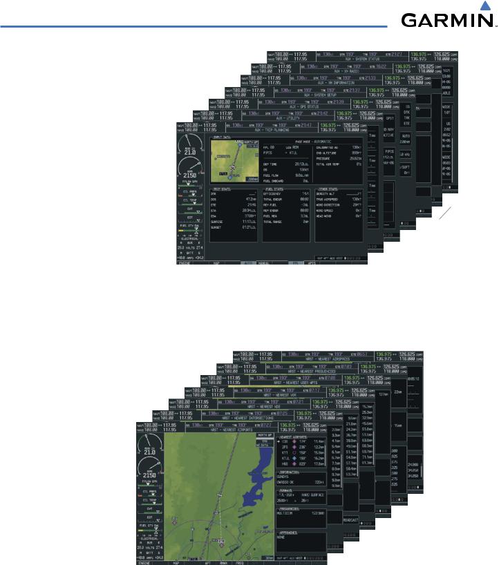
Auxiliary Pages (AUX) |
|
|
|
|
|
|
Trip Planning |
|
|
|
|
|
|
Utility |
|
|
|
|
|
|
GPS Status |
|
|
|
|
|
|
System Setup |
|
|
|
|
|
|
XM Satellite pages |
|
|
|
|
|
|
- XM Information |
|
|
|
|
|
|
(INFO Softkey) |
|
|
|
|
|
XM |
- XM Radio |
|
|
|
|
Satellite |
|
|
|
|
|
|||
|
|
|
|
|
Pages |
|
|
|
|||||
(RADIO Softkey) |
|
|
|
|
|
|
System Status |
|
|
|
|
|
|
|
Figure 1-25 Auxiliary Pages |
|||||
Nearest Pages (NRST)
Nearest Airports
Nearest Intersections
Nearest NDB
Nearest VOR
Nearest User Waypoints
Nearest Frequencies
Nearest Airspaces
Figure 1-26 Nearest Pages
In addition to the main page groups accessed exclusively using the FMS Knobs, there are pages for flight planning (FPL) and loading procedures (PROC) which are accessed by bezel key. In some instances, softkeys may be used to access the Procedure Pages.
1-30 |
Garmin G1000 Pilot’s Guide for Cessna Nav III |
190-00498-03 Rev.A |
SYSTEM OVERVIEW
The Flight Plan Pages are accessed using the FPL Key on the MFD. Main pages within this group are selected by turning the small FMS Knob.
The Procedure pages may be accessed at any time on the MFD by pressing the PROC Key. A menu is initialized, and when a departure, approach, or arrival is selected, the appropriate Procedure Loading Page is opened. Turning the FMS Knob does not scroll through the Procedure pages (note the single page icon in the lower right corner).
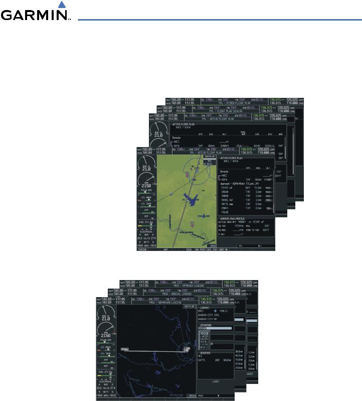
Flight Plan Pages (FPL)
Active Flight Plan
-Wide View, Narrow View (VIEW Softkey)
Flight Plan Catalog or
Stored Flight Plan (NEW Softkey)
Figure 1-27 Flight Plan Pages
Procedure Pages
(PROC)
Departure Loading
Arrival Loading
Approach Loading
Figure 1-28 Procedure Pages
For some of these pages (Airport Information pages, XM Satellite pages, Procedure pages), the title of the page may change while the page icon remains the same.
190-00498-03 Rev.A |
Garmin G1000 Pilot’s Guide for Cessna Nav III |
1-31 |