


FLIGHT INSTRUMENTS
SECTION 2 FLIGHT INSTRUMENTS
WARNING: In the event that the airspeed, attitude, altitude, or heading indications become unusable, refer to the backup instruments.
NOTE: TheAutomatic Flight Control System (AFCS) provides additional readouts and bugs on selected flight instruments. Refer to theAFCS Section for details on these bugs and readouts,as they appear on the display during certain AFCS modes.
Increased situational awareness is provided by replacing the traditional instruments on the panel with an easy- to-scan Primary Flight Display (PFD) that features a large horizon, airspeed, attitude, altitude, vertical speed, and course deviation information. In addition to the flight instruments, navigation, communication, terrain, traffic, and weather information are also presented on the PFD and explained in other sections of this Pilot’s Guide.
The following flight instruments and supplemental flight data are displayed on the PFD:
•Airspeed Indicator, showing
–True airspeed
–Airspeed awareness ranges
–Reference flags
•Attitude Indicator with slip/skid indication
•Altimeter, showing
–Barometric setting
–Selected Altitude
• Vertical Deviation, Glideslope, |
• Course Deviation Indicator (CDI) |
|
and Glidepath Indicators |
• Wind data |
|
|
||
• Vertical Speed Indicator (VSI) |
• Outside Air Temperature (OAT) |
|
|
||
• Horizontal Situation Indicator, |
• System time |
|
showing |
||
• Generic timer |
||
– Turn Rate Indicator |
||
• Vertical Navigation indications |
||
– Bearing pointers and |
||
|
||
information windows |
|
|
– DME Information Window |
|
The PFD also displays various alerts and annunciations.
190-00498-03 Rev.A |
Garmin G1000 Pilot’s Guide for Cessna Nav III |
2-1 |
FLIGHT INSTRUMENTS
|
23 |
22 |
21 |
|
20 |
19 |
1 |
|
|
|
|
|
|
|
|
|
|
|
|
18 |
2 |
|
|
|
|
|
17 |
|
|
|
|
|
|
|
|
|
|
|
|
|
16 |
|
|
|
|
|
|
15 |
3 |
|
|
|
|
|
14 |
4 |
|
|
|
|
|
13 |
5 |
|
|
|
|
|
12 |
6 |
|
|
|
|
|
11 |
7 |
|
|
|
|
|
|
|
|
|
|
|
|
|
|
|
|
|
|
|
10 |
8 |
|
|
|
9 |
|
|
1 |
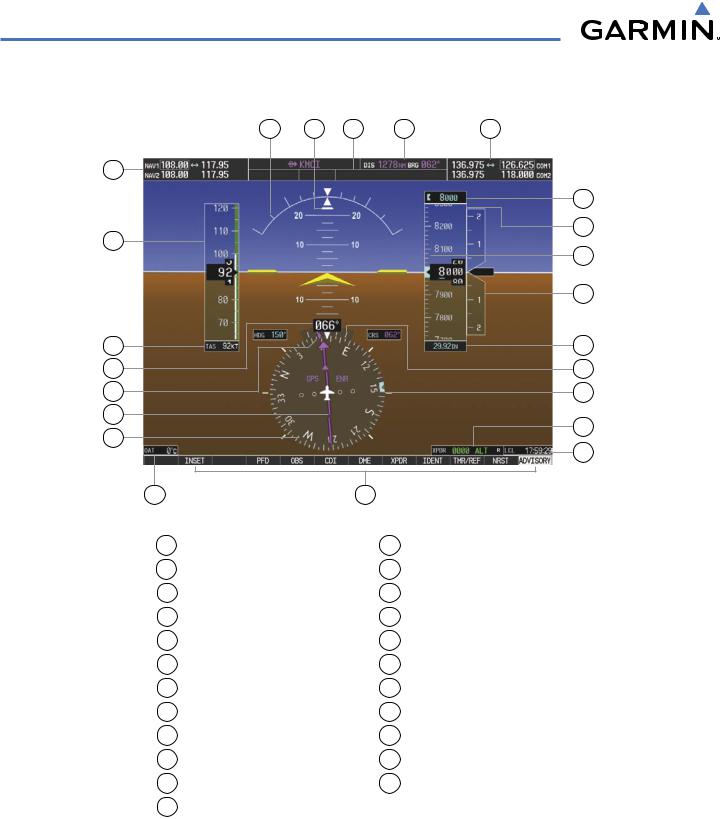
NAV Frequency Box |
|
|
13 |
Turn Rate Indicator |
|
2 |
Airspeed Indicator |
|
|
14 |
Barometric Altimeter Setting |
|
3 |
True Airspeed |
|
|
15 Vertical Speed Indicator (VSI) |
||
4 |
Current Heading |
|
|
16 |
Selected Altitude Bug |
|
5 |
Current Track Bug |
|
|
17 |
Altimeter |
|
6 |
Course Deviation Indicator (CDI) |
|
18 |
Selected Altitude |
||
7 |
Horizontal Situation Indicator (HSI) |
19 |
COM Frequency Box |
|||
8 |
Outside Air Temperature (OAT) |
|
20 |
Navigation Status Box |
||
9 |
Softkeys |
|
|
21 |
AFCS Status Box |
|
10 |
System Time |
|
|
22 |
Slip/Skid Indicator |
|
11 |
Transponder Status Box |
|
|
23 |
Attitude Indicator |
|
12 Selected Heading Bug
Figure 2-1 Primary Flight Display (Default)
2-2 |
Garmin G1000 Pilot’s Guide for Cessna Nav III |
190-00498-03 Rev.A |
FLIGHT INSTRUMENTS
15 |
14 |
1
2
3
4
5
|
6 |
7 |
8 |
1 |
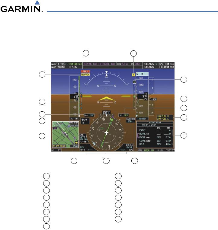
Traffic Annunciation |
9 |
Flight Plan Window |
2 |
Vspeed Reference |
10 |
Annunciation Window |
3 |
Selected Heading |
11 |
Selected Course |
4 |
Wind Data |
12 |
Current Vertical Speed |
5 |
Inset Map |
13 |
Glideslope Indicator |
6 |
DME Information Window |
14 |
Marker Beacon Annunciation |
7 |
Bearing Information Windows |
15 |
AFCS Status Annunciation |
8Minimum Descent Altitude/Decision Height
Figure 2-2 Primary Flight Display (Additional Information)
13
12
11
10
9
190-00498-03 Rev.A |
Garmin G1000 Pilot’s Guide for Cessna Nav III |
2-3 |